 is the time
or distance from i to the desired location that offers activity
k to serve a person at i with access type l.
is the time
or distance from i to the desired location that offers activity
k to serve a person at i with access type l.
In this section, the field test data are examined in the light of how the environment and the placement of locations and their cues affect the blind traveler. Kevin Lynch, in his seminal work “The Image of the City” ( 1960) used the term “legibility” to explain how certain parts of a city had features that led to a greater knowledge and awareness of feature locations and spatial interaction with other parts of the city. This section will show that “legibility” can also be applied to various locations and transit tasks in and around a transit terminal.
 is the time
or distance from i to the desired location that offers activity
k to serve a person at i with access type l.
is the time
or distance from i to the desired location that offers activity
k to serve a person at i with access type l.
 relative
accessibility of activity k from location i for person
type l relative to person of type m.
relative
accessibility of activity k from location i for person
type l relative to person of type m.The first four location types examined included nine of the 20 test destinations.
Figure 3.12 shows these nine locations grouped into the four specific types.
The averages for each group are also shown, representing the frequency
of each type of activity. Later, the other 11 locations that had a
wide range of non-visual cues available to the blind traveler are examined.
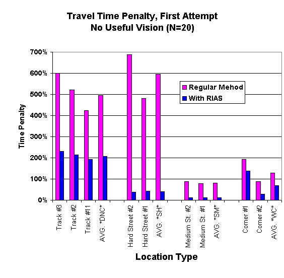
Subjects started the experiment with their back at an unnamed track door, and it was explained to them that all the trains came in from behind them. Therefore, they were aware of the spatial arrangement of all track doors being located only at the back wall of the terminal. The doors to the train boarding area were not marked with Braille or any raised or tactile information. Because of this, there was no way for blind subjects to identify the proper door. Even when they found a door, they had no way to know if that was the correct door or if they should go to their left or right to continue their search. If they did not ask for help, there was little possibility that a totally blind individual could find the proper location. This task was also rated as the most difficult from the 26 transit tasks shown in Table 3.1 . The difficulty of this task was also evident from the travel time data collected as subjects visited 3 different doors during the experiment. The extra time needed to find these 3 different unlabeled doors was quite similar, and the mean time penalty was 496% more than the FSU. The use of RIAS lowered this penalty to 208%. These penalties could be applied to other unlabelled doors that have some order but offer no other cues to their identity. These locations will be referred to as “Door, No Cues” or DNC.
Blind people are given training on crossing streets, and these locations
certainly offer many non-visual cues. However, as the experiment showed,
some streets are just too dangerous for them to cross because of high-speed
traffic and complicated traffic flows, such as turn lane cycles. Subjects
crossed to the mid-street transit platform (King St.) twice in the experiment,
and both directions were categorized as very difficult or hard. Some
subjects refused to cross the 2 lanes to the platform on their own, and others
had to wait through several cycles of the light to understand the traffic
flow. Crossing this street in both directions had a mean time penalty
of 595%, while with RIAS the extra time was only 41% more than a sighted pedestrian.
These locations are referred to as “Street, Hard Difficulty”
or SH.
Crossing 4th Street was much different than crossing King Street.
It was a congested city block with many cars and cabs stopped at the terminal
and had slow traffic. Therefore, there were many audible cues to the
traffic and turn cycle and much less danger from high-speed traffic.
Orientation and Mobility instruction and the subjects’ training are
well represented in this task. Subjects who used their regular aids
and skills were able to cross this street in both directions with a mean time
of 82% more than the FSU. With RIAS, subjects were able to cross the
streets with only 12% more time than the FSU. This measure was labeled
“Street, Medium Difficulty” or SM. An easy street might
be one with little traffic and stops signs.
Twice in the experiment, subjects walked to a street corner. There
are many non-visual cues to help identify a busy intersection. Orientation
and Mobility instructors also spend much time teaching these skills, and their
efforts are well documented here by these results. Subjects used dogs,
their cane, and traffic noise to identify the street and its intersection.
Both of these walks were at a significant distance from the start point,
but, as Figure 3.13 shows, this was not a difficult task for this group.
The mean extra time for the people using their regular aids and skills was
128% more than the FSU, and when they used RIAS they got there with only 69%
more time. This location measure is referred to as “Walk to Corner”
or WC.
For these four specific locations, it can be seen how difficult it is to
find unlabeled doors and how RIAS reduces the needless search time to collect
this information. Crossing a difficult street can be such a barrier
that one failed or stressful crossing may cause a trip to be abandoned.
While the blind subjects did quite well crossing the medium difficulty street,
the use of RIAS in both of these street crossing tasks took away the uncertainty
and stress of learning an intersection’s traffic flow, signal cycle,
and other idiosyncrasies. Without full attention to all these cues,
any street crossing can lead to injury or even death. It is no wonder
that many blind people do not travel independently to new areas. The
task of walking to a corner was not too difficult for this group, but, again,
RIAS helped speed up this process, especially in finding their way out of
the building and to the sidewalk.
The other 11 locations were not so easily categorized as to specific types
of locations. They were grouped using the “legibility”
(how easy they are to understand and locate, see Lynch, 1960) , or “rationality”
of their placement, as well as whether or not other cues were available to
inform the blind population. For example, it is usually a good spatial
search heuristic or tactic to assume that the bathroom for one sex is near
that for the other. Ticket sales are usually in a high-traffic, central
area near the entrance to a terminal or near the tracks. Other locations,
however, have no ‘standardized” or rational legibility.
They might have non-visual cues such as smells or distinctive sounds that
might be heard (for example, one might hear coins at a vending machine or
people using a phone or buying a ticket). Air currents and temperature
or light intensity changes can signal doorways and openings. Other locations
offer little in the way of cues to their existence. Figure 3.14 shows
the time penalty for subjects with no useful vision on their first attempt
for the other 11 tasks.
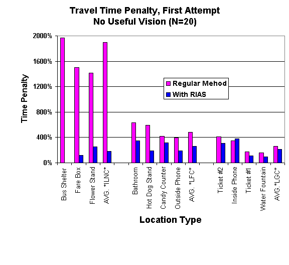
The bathrooms, hot dog stand, candy counter, and the outside public phones
had some non-visual cues. These types of locations had a mean penalty
for the regular users of 491%. When using RIAS, the penalty was reduced
to 265% more than the FSU. This measure is “Location, Few Cues”
or LFC.
Unlike the person with physical mobility impairments, such as severe arthritis,
a bad hip, chronic fatigue, or a weak heart, there is no consistent time penalty
that can be measured relating to the travel time of blind people. These
data show that the problems that cause a blind person to travel with less
efficiency in an environment are not necessarily some inherent disadvantage
caused by the lack of vision. Inconsistent locations with no cues and
doors with no labels cause large time penalties and stressful travel, while
locations with more environmental cues are much easier to find. It
appears that it is often the lack of directional and location identity cues
that cause the inefficient travel behavior (longer travel times) exhibited
by many blind travelers.
Time penalties increase as the number and types of trips increase. A more active traveler, who faces barriers to efficient travel, has more cumulative penalties than an inactive person. By summing up Equation 2 on page 170 , a formulation can be presented that compares two types of users, with different access mode criteria, over a wide range of activities. This formulation can be used to compare the daily, weekly, or longer variation in travel time for different groups. The cumulative relative access measure thus allows for examination of how time penalties combine, depending on the choice of activities, to restrict access due to time constraints.
Equation 3 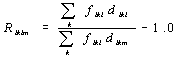
This equation is the same as Equation 2, except the time penalties are added together. Using this formulation, the access mode type can be varied to examine the overall time penalties or relative access measures. This formulation is modified so that starting location i is relaxed to mean any location i for a trip to activity or location k. For example, the mean time penalty for trips to the doors is added to the penalty for crossing the hard street, and all the other types of locations, to produce the total time penalty of the 20 destinations in this experiment. Table 3.8 shows five different ways to judge the time penalties faced by people with vision restrictions.
Table 3. 8 Impedance Coefficients for Various Locations
|
Specific Tasks and Locations |
General Locations |
|||||
|
Coefficients of Difficulty for Transit Tasks |
Door No Cues |
Hard Street |
Med. Street |
Corner Walk |
Location No Cues |
Location Few Cues |
|
Variable Name |
DNC |
SH |
SM |
WC |
ILNC |
LFC |
|
Blind, Regular Method / Sighted Baseline |
6.0 |
6.9 |
1.8 |
2.3 |
20.0 |
5.8 |
|
Blind, with RIAS / Sighted Baseline |
3.1 |
1.4 |
1.1 |
1.7 |
2.7 |
3.7 |
|
Blind, Regular Method – Blind, with RIAS |
2.9 |
5.5 |
0.7 |
0.6 |
17.2 |
2.2 |
|
Blind, Regular Method / Blind, with RIAS |
1.9 |
4.9 |
1.6 |
1.3 |
7.3 |
1.6 |
|
% Time Saved with RIAS versus Regular Method |
48% |
80% |
38% |
26% |
86% |
37% |
Using the above location time penalty coefficients, models can be produced
that will assist people interested in navigation without sight, especially
planners and O&M instructors, to apply these findings to other environments.
Producing a linear model of both experimental conditions and also of
the time saved between the conditions can identify more completely which types
of tasks present the most resistance to efficient travel. Three linear
models are presented that can be used to estimate the total travel time required
for a blind traveler, based on the time for a sighted and familiar user.
Prudent application of these models would allow a better understanding of
the difficulties that people without sight might face in a new environment,
without the need to collect data from a group of blind users first.
Architects and design professionals, especially transit planners, could test
their designs before they are built in order to ensure the best compliance
with ADA mandates. These models could help planners know where to concentrate
their mitigation efforts and add to the body of knowledge about barriers to
accessibility in urban environments. As the models show, it is the
environment, placement of destinations, and lack of cues that helps create
the penalty to navigation without sight much more than the inherent lack of
vision itself. A better designed and equipped environment would go
a long way to ensure that this group could use the facilities with independence,
efficiency, and dignity and would make the travel experience less stressful
and provide a higher degree of personal safety. Simply stated, the
model takes the time penalty coefficients for each of the six location or
activity types and multiplies them by the time it takes for a sighted traveler
to complete the tasks. When those numbers are summed, it reveals the
total time penalty.
The model is based on a linear model with the equation:
Y= e +B1X1 +B2X 2 +B 3
X3 +B 4 X4 +B5X5 +B6X
6
where:
The first model computes the extra time that blind travelers expend in different
locations, compared to a baseline (FSU) time. (Y) is the predicted value
of the time it would take for the blind to complete the tasks.
Equation 4
Model 1: Y = e +(6.0)DNC+(6.9)SH +(1.8)SM +(2.3)WC+(20.0)ILNC+(5.8)LFC
It can be seen that “inconsistent locations, no cues” (ILNC)
has a time penalty of 20, and crossing the difficult street (SH) has a penalty
of 6.9. In contrast, a location with little or few cues (LFC) has a penalty
of only 5.8 and crossing the medium difficulty street has a penalty of only
1.8. This type of model can be used in several ways. It is easy
to see that adding a few cues at certain locations (changing a location from
ILNC to LFC) would reduce the overall time penalty for a trip. In addition,
re-routing the trip could also reduce overall penalties. In this example,
it would be faster to cross two medium difficulty streets (SM) than to cross
one street with hard difficulty (SH). The goal of increasing access can
be met by designing spaces to reduce the cumulative penalty (Y).
The second model allows for computation of the reduced time penalty in an environment
if directional and identity cues were available, as when using RIAS. (Y)
is the predicted value of the time it would take for the blind to complete the
tasks when using RIAS, as compared to a sighted user.
Equation 5
Model 2: Y = e +(3.1)DNC+(1.4)SH +(1.1)SM +(1.7)WC+(2.7)ILNC+(3.7)LFC
In this model, it is clear that the time penalty between hard (SH) and medium
difficulty (SM) streets has become quite similar, unlike in Model 1, and other
penalties are smaller as well. This would produce a much lower total
penalty (Y) than Model 1, for the same route and activities.
To determine how much time could be saved when a blind person has access to
additional auditory cues, a third model shows the effect on environments’
“legibility” and ease of use when a system like RIAS is installed.
(Y) is the predicted value of the time saved when using RIAS to the time
of the blind using their regular methods. In this model, X1
– X6 are the walk and search times of the regular blind user.
Equation 6
Model 3: Y= e +(48%)DNC+(80%)SH +(38%)SM +(26%)WC+(86%)ILNC+(37%)LFC
Using the mean travel time of blind travelers, this model can estimate the savings
when using accessible cues, such as RIAS. For example, it shows that
RIAS might save 48% of the time to find unlabeled doors (DNC), 80% to cross
hard streets (SH), and 86% at those locations that are inconsistent and have
no cues (ILNC).
There is no consistent restriction or time penalty that can be assigned to the search times for blind travelers. These data and the models should allow planners to consider which locations demand attention in order to help mitigate barriers to access. Spatial knowledge acquisition, especially for people who are blind, can be increased with proper attention to the consistent location of amenities. Accessibility for the blind can also be increased by giving more attention to providing cues to these locations, including the use of identity and directional cues as provided by RIAS. The continued existence and acceptance of such high penalties and barriers to independent travel should be robustly questioned and examined by anyone concerned about providing access to urban opportunities and an equitable society for all people.
| BACK TO OVERVIEW | BACK TO TABLE OF CONTENTS | NEXT SECTION |