


|
|
|
Urban Change - Integrated Modeling Environment
PROJECT DESCRIPTION
RESULTS FROM PRIOR NSF SUPPORT
In the past five years Helen Couclelis has been one of several co-PIs on NSF grants SES88-10917 (extended 1993-97) and SBR96-00465 (1997-99) to the National Center for Geographic Information and Analysis (NCGIA). Within the broad research mission of the NCGIA Coucleliss work has approached geographic information science from the perspective of urban modeling and planning and the requirements to making geographic information science useful to individuals and society. NCGIA/NSF support for the 1993-98 period has resulted in 23 publications (5 articles in refereed journals, 8 chapters in refereed conference proceedings and books, 5 journal editorials, one co-edited book, one edited conference report, two short papers in conference reports and one article on GIS in a technical encyclopedia (see list below). She has participated in numerous national and international conferences and workshops, many of them sponsored in whole or in part by NCGIA, and was invited to give three keynote lectures at European conferences (listed below). She was chair of the organizing committee for a research conference on Spatial Technologies, Geographic Information, and the City in Baltimore, MD in September 1996. Her contributions to the development of human resources in science and engineering included organizing a national paper competition for early-career US scientists, supervising the selection of the winners, and chairing the organizing committee for the First International Young Scholars Summer Institute in Geographic Information that took place in Wolfes Neck, ME in July 1995. The week-long Summer Institute involved some thirty early-career and twelve senior researchers from the US. Corresponding numbers of European young and established scholars attended, sponsored by the European Science Foundation through their GISDATA program. An outcome of the Summer Institute was an edited book published by a major international publisher (Craglia and Couclelis, 1997). Couclelis also served on the organizing committee for the second such Summer Institute that took place in Berlin, Germany the following year and produced a second volume of research papers. Couclelis was also PI on a NSF-Dissertation Research Grant (SBR9304644, 1993-95) for Emily Talen. Dr. Talens dissertation was completed in 1995 and resulted in several sole-authored refereed publications.
NSF/NCGIA-supported publications by Helen Couclelis, 1993-98
Batty, Michael, Helen Couclelis, and Marc Eichen (1997). Urban systems as cellular automata. Environment and Planning B: Planning and Design 24, no. 2: 159-64.
Couclelis, Helen (1993). The last frontier. Environment and Planning B 20:1: 1-4.
(1993). Making space for time: towards a truly temporal geography. In Time in geographic space: specialist meeting, Lake Arrowhead, CA, May 8-11, 1993., 1-9. National Center for Geographic Information and Analysis.
(1994). Geographic Information Systems. In McGraw-Hill Yearbook of Science and Technology. 1995 ed., ed. S. P. Parker, 179-81. New York: McGraw-Hill, Inc.
(1994b). Spatial technologies. Environment and Planning B 21:2: 142-43.
(1995). Bridging cognition and knowledge. In Rethinking knowledge: reflections across the disciplines. eds. R. F. Goodman, and W. R. Fisher, 196-206. Albany, NY: State University of New York Press.
(1996). The death of distance. Environment and Planning B: Planning and Design 23: 387-89.
(1996). End of a working day, ten years hence. Environment and Planning B: Planning and Design 22:6: 631-33.
(1996). Geographic illusion systems: towards a (very partial) research agenda for GIS in the information age. In GIS and society: the social implications of how people, space, and environment are represented in GIS. Scientific report for the Initiative 19 Specialist Meeting , eds. T. Harris, and D. WeinerSanta Barbara, CA: National Center for Geographic Information and Analysis.
(1996). Spatial technologies, geographic information, and the city., TR 96-7. National Center for Geographic Information and Analysis, Santa Barbara, CA.
(1996). Towards an operational typology of geographic entities with ill-defined boundaries. In Geographic objects with indeterminate boundaries. eds. Peter A. Burrough, and Andrew U. Frank, 45-55. London: Taylor & Francis.
(1996). Verbal directions for way-finding: space, cognition, and language. In The construction of cognitive maps. Ed. J. Portugali, 133-53. Dordrecht: Kluwer Academic Publishers.
(1997). From cellular automata to urban models: new principles for model development and implementation. Environment and Planning B: Planning and Design 24, no. 2: 165-74.
(1997). GIS without computers: building geographic information science from the ground up. Innovations in GIS - 4: Selected papers from the Fourth National Conference on GIS Research UK (GISRUK). editor Zarine Kemp, 219-26. London: Taylor & Francis.
(1998). Geocomputation and space. Environment and Planning B: Planning and Design 25.
(in press). Geocomputation in context. In GeoComputation: a primer. Editors Paul Longley, Susan Brooks, Bill Macmillan, and Rachel McDonnellCambridge: GeoInformation International.
(in press). Space, time, geography. Geographical Information Systems: principles, techniques, management, and applications. 2d ed., eds. Paul Longley, Michael Goodchild, David Maguire, and David RhindVol. 1. New York: Wiley.
(in press). Spatial information technologies and societal problems. eds. Massimo Craglia, and Harlan OnsrudLondon: Taylor & Francis.
(in press). Worlds of information: the geographic metaphor in the visualization of complex information. Cartography and Geographic Information Systems .
Couclelis, Helen, and Jonathan Gottsegen (1997). What maps mean to people: denotation, connotation, and geographic visualization in land-use debates. Spatial Information Theory: a Theoretical Basis for GIS. International Conference COSIT'97. eds. Steven Hirtle, and Andrew U. Frank, 151-62. Lecture Notes in Computer Science, no. 1329. Berlin: Springer-Verlag.
Couclelis, Helen., and Mark Monmonier (1995). Using SUSS to resolve NIMBY: how Spatial Understanding Support Systems can help with the "Not In My Back Yard" syndrome. Geographical Systems 2: 83-101.
Craglia, Massimo, and Helen Couclelis (1997). Geographic information research: bridging the AtlanticLondon: Taylor & Francis.
Takeyama, Masanao, and Helen Couclelis (1997). Map dynamics: integrating cellular automata and GIS through Geo-Algebra. International Journal of Geographical Information Systems 11, no. 1: 73-91.
Batty, Michael, Helen Couclelis, and Marc Eichen (1997). Urban systems as cellular automata. Environment and Planning B: Planning and Design 24, no. 2: 159-64.
Keynote lectures by Helen Couclelis directly related to the work supported by NSF/NCGIA
The Taylor & Francis Lecture, 4th GIS Research in the UK (GISRUK) Conference, Canterbury, UK, April 1996.
The UNIGIS Lecture, Inaugural meeting of the Association of European Laboratories in Geographic Information (AGILE), Enschede, The Netherlands, April 1998.
The Pion Lecture, Third International Conference on Geocomputation, Bristol, UK, September 1998.
Objectives
Contemporary urbanization dynamics in the United States are inextricably linked with the forces and processes of technological restructuring, globalization, and the information society (Office of Technology Assessment 1995; Castells 1996; Graham and Marvin 1996). Current changes in urbanization patterns at all geographic scales are quite likely the most significant since the railroad and especially the automobile turned American cities inside out almost a century ago. Examples of these new patterns and processes are: urban deconcentration and centralization, the formation of exurbs and edge cities (Garreau 1988), the colonization of remote rural and wildland spaces, the emergence of new types of urban specalizations, (e.g., technopoles), increasing spatial segregation of races and income groups, increasing spatial mismatch between low-income residents and jobs, the spatial disintegration of labor markets, increasing threats from natural hazards as urban structure becomes more dispersed and internally complex, and the exposure of urban areas to more and new kinds of vulnerabilities brought about by their increasing dependence on technology (Hart 1991; Knox 1993; Barras 1987).
These changes involve all the key components of urban systemshuman, natural, and builtand their interactions both at specific geographic scales and across scales. They afford opportunities but at the same time create new problems for urban futures that we are not yet equipped to understand. Urban theories and models abound but most are valid only at specific scales (e.g., neighborhood, metropolitan area, or regional scale) and/or address a rather narrow spectrum of issues from within a particular disciplinary perspective (e.g., economic, environmental, planning, transportation, etc.). While specific models must necessarily be tailored to specific questions and levels of analysis, few if any classes of models are sufficiently versatile to provide a common framework for modeling and linking together diverse aspects of urban dynamics across geographic scales, times, domains, and particularly across disciplinary perspectives.
The socioeconomic, natural and technological conditions and processes in today's society both drive and are profoundly affected by the evolving urban spatial structure within which they operate. We believe that the ability to model the changing morphology, or built form, of contemporary American urbanization at different scales and from different perspectives is critical to understanding a host of other phenomena associated with the contemporary urban realm. We propose to develop an integrated modeling environment (IME) that will help meet that need. Our primary objective is to provide the conceptual and technical infrastructure needed for modeling the changing urban spatial patterns as these relate to the key components of urban systems (human, natural and built) and their interactions (IME-1). Further, we will explore the conditions under which that modeling environment may be expanded, through incorporation of additional kinds of model structures and tools, so as to allow the exploration of other aspects of urban change beyond the spatial patterns themselves (IME-2). Within that general framework we will develop, analyze and compare specific models for selected major urban areas. Our work will build on Clarke's successful simulation models of two major metropolitan areas of the US (Baltimore/Washington and San Francisco) and on the theoretical work of Couclelis on cellular automata (CA), the modeling paradigm underlying Clarke's models. Colleagues from the Los Alamos National Laboratory (LANL) and the United States Geological Survey (USGS) will collaborate on the research, bringing in complementary strengths deriving from two other significant modeling efforts: the Urban Security and the Urban Dynamics/Urban Retrospectives Initiatives, respectively. The linkage of these two major projects through ours will be an additional contribution of our research. More specifically, the main objectives of our proposed research are as follows:
1. To develop a conceptual and technical infrastructure for modeling the changing morphology of contemporary US urban areas, at different scales, as a function of key social and physical processes and constraints (IME-1), as well as more general aspects of urban system dynamics for which urban morphology serves as a key input (IME-2).
2. To demonstrate and test the validity of the approach at the IME-1 level through modeling and analyzing the growth patterns of selected metropolitan regions.
3. To demonstrate and test the validity of the approach at the IME-2 level with a study seeking to predict land use intensity and population distribution through coupling of several different models of physical and human processes, including a model of urban morphology.
4. To implement and disseminate an integrated GIS-based modeling environment (IME-1 & 2) as outlined above for the investigation of a variety of research and policy questions pertaining to urban structure and change.
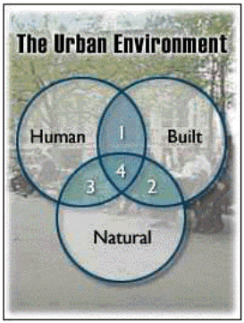
The following are examples of types of questions that may be addressed using the modeling environment we plan to develop. In all of these the changing urban spatial structure is either directly the focus or a key factor in the phenomena of interest. In this research we touch upon only a small number of these questions in the course of setting up and testing the two levels of the modeling environment. The figure shows how such issues relate to the scope of the NSF Urban Dynamics Initiative.
Intersection 1: Human-built. Changes in accessibility through: new urban forms (e.g. nucleated, dispersed); new land use structure; expanding transportation, telecommunications and information infrastructure; shrinking distances between metropolitan commuter sheds; merging of metropolitan areas. Changes in urban and rural land value structures through changed demand for, and availability of, central vs. peripheral land. Serious disruptions to urban structure and function through accident or design (e.g., major freeway congestion events; major blackouts; terrorist attacks on infrastructure)
Intersection 2: Built-natural. Increased intrusion of urbanized areas into natural environments caused by urban fragmentation and the ensuing fast-growing diameter and especially total perimeter of urban areas: disruption of ecological corridors; ecosystem fragmentation; loss of agricultural land; urbanization of marginal land (slope, brush, floodplain); drainage basin disruption. Urban steering effect of attractive natural environments.
Intersection 3: Human-natural. Increased human exposure to environmental health and safety risks (e.g., Lyme disease, encounters with threatening wildlife) due to the fast expanding total perimeter of the urban fringe. Impact of climatic extremes (e.g., heat waves, severe rain- or snowstorms) on urban populations depending on location. Effects on climate of urban heat island. Effects of increased opportunities for outdoors recreation on community budgets for parks and playgrounds.
Intersection 4: Human, built, natural. Increased exposure of urban areas to pervasive (e.g., air and water pollution, drought) or catastrophic (e.g., wildfires, floods) environmental hazards; sudden changes to urban structure and infrastructure brought about by catastrophic events (e.g., earthquakes) and processes of recovery from such events. Spatial diffusion patterns and human effects of major toxic spills or releases within urban areas. Emergency planning identification of hard to evacuate areas. Effects of global climate change on the long-term planning of water reservoir networks for metropolitan areas.
All these issues involve changes in urban spatial structure as a key element, combined with a large variety of other natural and human factors. Our integrated modeling environment, designed with a dynamic urban morphology model at the core and the possibility to couple this with a range of models of other kinds of phenomena, can help researchers and policy makers explore these and other such questions critical for modern urban society.
Expected Significance
The contributions of the proposed research will be theoretical, methodological and applied. The integrated modeling environment we propose to develop will:
In addition to the research contributions, we will use the human and technical resources of the project to develop one graduate and one undergraduate course in the Geography Department at UCSB. These courses, to be Web-oriented and easily emulated elsewhere, will teach the systematic aspects of urban change in a hands-on modeling environment that will allow students to learn about urban interactions through performing, analyzing and discussing simulation experiments performed with actual data on a GIS.
Relation to the present state of knowledge in the field
The proposed framework for modeling urban change will build on the strengths of several decades worth of modeling efforts while making distinct contributions of its own to the urban and regional modeling literature and practice. The study of changing urban structure can be approached from several different perspectives. Two or more static "snapshots" of an urban area represented at different points in time may be compared and described qualitatively or quantitatively. Causal explanations for observed or predicted changes in the distribution of key urban variables (e.g., jobs, population densities, traffic densities, or land values) may be sought in economic and behavioral principles. Or one may attempt to represent the mechanisms of change themselves, tracking how some types of events or changes in some areas can accelerate or retard other types of events or changes in other areas of the urban system. In all cases, statistical models and techniques are needed to analyze and compare model outputs and assess the validity of the results. For the purposes of this research, urban, regional and related spatial models may be classified into the following three categories, which roughly correspond to the three approaches to the study of urban change mentioned above: (a) empirical regularities; (b) causal (explanatory) models; and (c) dynamic simulation models. In addition, (d) models from other disciplines are sometimes used in combination with spatial urban models, and are particularly important for this project.
(a) Models expressing empirical regularities among variables of the urban system were among the first to be formulated in quantitative terms. Prominent members of this group are the gravity family of models of spatial interaction, arguably the best known and most successful of all models in human geography (Wilson 1971; Haynes and Fotheringham 1984). Other examples are Clark's 'law' which relates urban density with urban size (Clark 1951) and the rank-size rule relating city size and city rank in the national urban hierarchy (Marshall 1989) These models are well suited for "before and after" (or "then and now") types of studies of urban change. They provide no causal explanations for the phenomena they portray but have established themselves as fairly reliable tools for certain kinds of comparative analysis and prediction. Their robustness derives from the fact that the empirical regularities they express have been subsequently shown to be statistical most probable system states given certain simple assumptions (Wilson 1974; Slater 1978; Fotheringham and O'Kelly 1989).
(b) Causal (explanatory) urban and regional models have strengths and drawbacks complementary to those of the first group. They are built on the basis of explicit assumptions about human behavior and other forces believed to shape urban systems and are thus designed to provide explanations for the spatial patterns they generate. However, because of the difficulty of capturing human behavior in a few simple assumptions, their correspondence with specific real world patterns and processes is tenuous at best. The first generation of these models (Christaller's central place theory; Alonso-Muth's theory of land value and residential structure; the Weber-Loesch theory of industrial location, etc. (see Cadwallader 1996) sought to emulate the axiomatic structure of physical theory by adapting assumptions from the 'rational man' paradigm of microeconomics to the properties of geographic space, in particular the friction of distance. They provided elegant thought experiments illuminating the implications of certain kinds of optimizing behavior for urban structure and the location of activities, but did not claim to replicate empirical situations, the real world being too 'messy' to exhibit the pure rational effects hypothesized by the models. More recent work on individual choice models has considerably increased the realism of causal urban modeling through incorporation of information on actual rather than idealized human behavior, such as in the choice of housing, shopping, or transportation (Fischer and Nijkamp 1985). Properly calibrated, these models can reproduce observed patterns quite well, and they can also trace the consequences of minor changes in the choices available to individuals or in their circumstances. However, because the preferences and behavioral constraints these models incorporate are very much a function of current spatial and temporal conditions, they are not easily transferable to new situations. Most individual-based models also suffer from the aggregation problem, or the theoretical difficulty of predicting the impacts on urban structure from the sum of individual actions, and thus operate against an essentially static urban back-cloth. Still, these models encapsulate the powerful notion that individual decisions are vital to the explanation of a variety of urban phenomena. The next group of models successfully takes up that theme in a dynamic context.
(c) Simulation models can reproduce observed patterns with remarkable accuracy. They also are the only class of urban models to be truly dynamic in the sense that they are capable of endogenously predicting urban change. Simulation models have become widely popular in a variety of different natural and social science disciplines as a result of both computational and theoretical advances (in particular, advances in the theory of complex systems). Their ability to incorporate large numbers of variables, to trace the compound effects of large numbers of relationships, and to generate a broad spectrum of sometimes surprising solutions make them very attractive virtual laboratories for exploring alternative hypotheses or systems futures. However, simulation models do not provide explanations in the causal sense beyond the effects of the often ad hoc relations or rules explicitly coded into them.
The history of urban simulation models began with a splash in the late sixties with the publication of Forresters Urban Dynamics (Forrester 1969). Forresters model, developed in the tradition of the systems approach, consists of three major coupled subsystems (private enterprise, residential sector, and employment), each of them consisting of several linked components. The model was built in analogy with hydrological system models, consisting of stock and flow variables. Forresters Urban Dynamics model was heavily criticized at the time but made some lasting contributions to the urban modeling field. Of particular relevance to our project was the demonstration that complex dynamic models of urban systems can be built with the same basic techniques and vocabulary used in modeling a variety of physical systems, thus opening the way for an integration of social and natural science modeling (Wilson 1981). Coupled system models in the tradition of Forresters are still routinely used in modeling physical processes related to urban change, with several major examples being developed by our LANL colleagues in the context of the Urban Security initiative, as outlined under (d) below.
The other major approach to urban dynamic modeling is that of the complex systems paradigm (Albin 1975; Batty 1993; Batty and Longley 1994; Casti 1984; Gleick 1988; Michaels 1995). Complex systems in any domain are characterized by certain properties such as non-linearity, self-organization, and emergence. In the US the study of complex systems has been closely associated with the Santa Fe Institute (Waldrop 1992; Cowan, Pines, and Meltzer 1994; Kaufman 1995) with which our LANL colleague Dr. Rasmussen is affiliated as Researcher in Residence. Three main streams in complex systems modeling have been followed in the urban and regional literature. The first, based on Thoms (1975) Catastrophe theory, sought to replicate the sudden appearance or disappearance of major urban features (such as shopping centers) under gradual change of certain critical parameters (White 1981; Wilson 1976, 1979a, 979b). The second stream transposed into the urban realm the Brussels School theory of dissipative structures (also known as "bifurcation theory") developed in physical chemistry by Prigogine and his colleagues (Prigogine 1980; Prigogine and Stengers 1984; Allen 1980, 1982; Allen et al. 1978; Allen and Sanglier 1978, 1981); Pumain, Sanders, and Saint-Julien 1989). The goal here is to study how urban dynamics trajectories can on occasion suddenly change course as a result of random fluctuations in some parameters. The third stream, which is the one followed here, is that of cellular automata (CA). Basic cellular automata consist of arrays of cells the states of which are simultaneously updated at each tick of the clock as a function of their own current state and that of their neighbors (Wolfram 1986; Gutowitz 1991). CA models are particularly relevant to urban and regional research because there are explicitly spatial. They also link localized interactions with large-scale structural change, thus bridging the disaggregate and aggregate (or individual and global) scales of analysis. In the geography literature, following a series of theoretical papers in the 1980s (Tobler 1979; Couclelis 1985, 1986, 1987, 1989; White 1989), the popularity of cellular automata models in urban and environmental modeling exploded in the 1990s, largely as a result of their natural affinity with GIS data structures, operations and data bases (Batty, Couclelis, and Eichen 1997; Batty and Xie 1994, 1997; Clarke at al. 1997, Couclelis 1997; Semboloni 1997; (Portugali and Benenson 1995; Sanders et al. 1997; White and Engelen 1992, 1996, 1997, in press; ; White 1994; Xie 1995). Parallel efforts have aimed at developing modeling languages based on CA principles for the integration of GIS with urban or environmental modeling (Takeyama and Couclelis 1997; Park and Wagner 1997). A fully implemented such language for dynamic modeling, named PCRaster, was developed in the laboratory of our external collaborator Dr. P. Burrough (Burrough 1998; van Deursen 1995). Recent extensions of cellular automata include the development of agent-based simulations, where the units (cells or points) can change position in model space along with their encapsulated decision rules. The Department of Transportation-sponsored TRANSIMS traffic simulation model, with which Dr. Rasmussen has been closely involved, is of that type (Nagel at al. 1994, 1997). A simulation platform called Swarm has also been developed to facilitate experiments with such models (Minar 1996).
(d) A number of models from other disciplines are commonly used to provide inputs to the urban models proper. Demographic and regional economic models typically provide the key inputs of population and employment growth and are routinely coupled with models of urban morphology and land use. Transportation and land use are so interdependent that they are often integrated in a single land use - transportation model. Our LANL colleagues have been directly involved in the development of the Transportation Simulation and Analysis (TRANSIMS) model and we will capitalize on their expertise in that area. However, few if any models of natural phenomena are ever considered in conjunction with urban models. This is partly due to the traditional isolation of the social and physical sciences from one another, but also to the fact that the theoretical frameworks on which urban models are built (usually based on economic or/and behavioral assumptions) are incompatible with those of natural science models. Given the increased penetration of urban areas into rural and natural space, the increased exposure of both urban structures and populations to natural phenomena (wildfires, floods, landslides, droughts, etc.), as well as the increased disruption of natural processes through urban expansion, the inability to deal with natural as well as socioeconomic processes is a major weakness of current urban modeling paradigms. Our research is designed to address this weakness through the development of a modeling environment that can seamlessly integrate the two. Efforts currently underway at LANL under the auspices of the Urban Security initiative include the development of mesoscale atmospheric models (RAMS and HOTMAC), atmospheric and water chemistry models, storm-water models, fire spread models, etc., all intended to be coupled with urban models within a GIS (see Los Alamos National Laboratory, 1997).
In summary, all four of the above types of models can be used in some way or other to describe, measure, explain, predict, speculate on, or visualize different aspects of urban change, from either a physical or a social science perspective. By making possible their selective and controlled use within a flexibly integrated modeling environment we hope to create the opportunity for many different kinds of researchers to capitalize on their combined strengths
Relation to work in progress by the PI under other support and/or in progress elsewhere
The point of departure of the proposed research is a model devised by Keith Clarke, with support from the USGS. That work originated from a land use change history for central California centered on San Francisco (Bell, Acevedo, and Buchanan, 1995) which was used to calibrate a prototype urban growth model based on a cellular automaton (Clarke, Gaydos and Hoppen, 1996). The work has produced a Web-accessible urban predictive model with a full calibration data set, a suite of tools for rigorous calibration, and Web-based documentation (Clarke, et al., 1996). A Regional Spatial Database Calibration Testbed, established for NASAs Earth Observing System (EOS) program partly for the purpose of calibrating the model and covering the Baltimore/Washington area (Foresman et al., 1995; Acevedo et al., 1996; Clarke, Hoppen and Gaydos 1996; Crawford et al., 1996) provided the necessary data base to generate forecasts for that metropolitan area and examine some of the regional-scale implications. Collaborators were the USGS, NASA and many others. The project also pioneered new methods for visualizing and disseminating the model outputs (Hoppen et al.,1996; Gaydos, et al., 1995; Masuoka, et al., 1996).
Applications of the model beyond the authors work have included a planning application to Sterling Forest, New York (Kramer, 1996); application to surface energy exchange and climate modeling in Chester County, Pennsylvania (Owen et al., 1997); and application to biodiversity preservation (Cogan et al., 1997). Clarke has obtained continued funding from the USGS for the further development of the model. 1998 support has focussed on making the model portable, so that applications can be developed at other agencies such as at the EPA, as well as within different mapping centers at USGS. In addition the scaling issues associated with the model are being investigated to determine the range of scales or the resolution at which the model is useful for urban forecasting, and to examine the role it may play in global change research. The Clarke cellular urban growth model is briefly outlined below under research Task One.
The work of Helen Couclelis on complex spatial dynamic systems dates back to the mid-1980's when a series of theoretical papers were published on the applicability of cellular automaton (CA) models to urban and regional modeling (Couclelis 1985, 1986, 1987). Their potential role as planning and policy analysis tools was also explored (Couclelis 1989). These papers were the first on CA modeling to appear in the geographic literature and are still widely cited. In more recent years CA models have become popular in geography and related spatial sciences, moving from the realm of theoretical exploration to empirical applications, as outlined above. This latter development was facilitated by the natural affinity of the structure of CA models with GIS databases and operations (van Deursen 1995, Park and Wagner 1997). Recent work in that area by Couclelis and Takeyama has produced a formal modeling language called GeoAlgebra for integrating generalized CA modeling and GIS (Takeyama and Couclelis 1997). GeoAlgebra is based on a new theoretical conception of space called proximal space that logically integrates absolute space, which underlies the geocoded information of GIS, with the relative space reflected in most distance-based geographical models (Couclelis 1997). Work currently in progress investigates the implications of the notion of proximal space and GeoAlgebra for understanding and modeling accessibility in urban systems. Couclelis has also co-edited the March 1997 special issue on CA of the journal Environment and Planning B: Planning and Design 24:2 (Batty et al. 1997). Her other recent activities related to the theme of this proposal include: the organization in 1996 of an international research conference in Baltimore, MD entitled "Spatial Technologies, Geographic Information, and the City" (Couclelis 1996); co-chairing the July 1997 NSF workshop on "Understanding Urban Interactions" (see http://www.nsf.gov/pubs/1998/sbe981/sbe981.htm). She currently serves on the steering committee for the upcoming (November 1998) specialist meeting on "Measuring and representing accessibility in the Information Age" organized by the NSF-funded National Center for Geographic Information and Analysis (NCGIA) (see http://bbq.ncgia.ucsb.edu:80/varenius/access/call.html), and on the panel for the "Geographies of the Information Society" group of NCGIA research initiatives. She is listed as an international partner on a research proposal similar to the present one in preparation by Drs. P. A. Burrough and E. Wever, University of Utrecht, the Netherlands, and entitled "Viable Cities in Sustainable Landscapes: Integrated research into the dynamics and management of urban and landscape networks in Northwest Europe" (see letter of collaboration by Prof. Burrough).
The Los Alamos National Laboratory is pursuing a major project entitled the Urban Security Initiative. In this multi-faceted project, a number of parallel modeling efforts are under way to examine the potential effects on urban areas of various pervasive or catastrophic physical events. Examples of that work include modeling the effects of global climate change on the water supply of the city of Albuquerque, the analysis of emergency response in cases of airborne toxic release over an urban area, the effect of individual transportation decisions on traffic-generated air pollution, and the process of regeneration of a major city after a catastrophic event. The general approach used is complementary to that proposed here, emphasizing the linkage of cross-disciplinary subsystem models and tailoring them for urban applications, with GIS playing a similar integrative role (Los Alamos National Laboratory 1997). Subsystem models based on cellular automata principles are being used by LANL for the urban structure component following the work of Roger White (White and Engelen 1992, 1996, 1997; White, in press), and for transportation modeling in the TRANSIMS traffic simulation (Nagel et al. 1994, 1997). These are linked to a series of physical models of hydrological, atmospheric, geological, etc. processes. In addition to the model development work, members of the Urban Security team are pursuing fundamental theoretical questions in complex systems dynamics, such as emergence, hierarchical self-organization, and distributed decision making, that parallel some of our research questions described under Task One below. Through Dr. Steen Rasmussen, a physicist involved with complex systems research (Rasmussen et al. 1997, Meyer and Rasmussen 1998, Meyer and Rasmussen, in press, Feldberg et al. 1994), and Mr. David Fogel, a GIS specialist completing a PhD on remotely sensed data, we have established working connections with the research team responsible for the Urban Security Initiative. We hope to use this project to cement these links into formal collaborations, as reflected in the associated proposal by LANL.
In addition to its multi-annual support of the Clarke model, the United States Geological Survey has a broader data collection project under way entitled Urban Retrospectives, involving all of the National Mapping Divisions Mapping Centers. Urban Retrospectives will build data sets for application of the Clarke model to the urban regions of New York, Philadelphia, Chicago, and Portland, Oregon. By linking this project formally to Urban Retrospectives through the parallel proposal by USGS, we hope to be able to assist in the modeling efforts for those urban areas, to be conducted by the USGS under its Urban Dynamics initiative. Our primary interest however is in using the data from these as well as the current Gigalopolis project cities to further basic research and development work on the integrated modeling environment proposed here, as described in more detail under Tasks Three and Four below. Our long-time USGS collaborator Mr. William Acevedo and Ms. Janice Buchanan will provide critical support with these tasks.
General Plan of Work: Research Design
The general plan of work consists of four major tasks. These correspond to the four major objectives of the research as outlined above. Work at USGS and LANL is integrated with these tasks, so it is not discussed separately here. Each task will have a task manager (the first name listed for each task) as lead for meetings scheduling and work assignments, and up to four researchers assigned to it as key personnel. The management plan for the project will revolve around bi-weekly meetings of the UCSB PIs and monthly meetings and/or conference calls with the remote collaborators. The project management will be coordinated from UCSB and will include a project Web site, to be made accessible to the public after the first year, for posting results, paper abstracts, progress reports, pointers to related work elsewhere, suggestions from visitors to the site, and for running model demonstrations. Each of the two collaborating sites will be visited by one of the PIs each year, and will provide annual activity reports. The overall tasks and their specific goals and work plans are as follows:
Task One: Conceptual and technical framework (Couclelis, Clarke, Rasmussen, Scott)
This task will build the foundation upon which the remainder of the research will rest. The point of departure of this effort will be the CA-based simulation model developed by Clarke and his collaborators and successfully implemented for the Baltimore/ Washington and San Francisco metropolitan areas. The Clarke model is a cellular model defined on a regular square grid. State transitions among land uses from one time period to the next take place by means of a set of rules that involve selecting a location at random, checking the attributes of the neighboring cells, and either "urbanizing" the cell or not, depending on a set of probabilities weighted by its own locational attributes. Five factors control the behavior of the system. These are: a diffusion factor, which determines the overall dispersiveness of the distribution both of single developed grid cells and of new built up clusters; a breed coefficient, which determines how likely a newly generated detached built up cluster is to begin its own growth cycle; a spread coefficient, which controls how much normal outward "organic" expansion takes place within the system, a slope resistance factor, which influences the likelihood of settlement extending up steeper slopes; and a road gravity factor, which has the effect of attracting new built up areas towards the existing road system if they fall within a given distance of a road. These factor values were set by the user for every model run and were manipulated as part of the calibration process. In the latest version of the model the system is input/output coupled. This means that after reacting to the rules, aggregate statistics of the distribution are measured, compared with "critical" rates, and the rules themselves are then modified accordingly. Few cellular automata models have implemented this kind of adaptive self-modification.
The model is calibrated with historical data on urban extent and road patterns. The past is then used to predict the present, using years for which real data exist as control. For San Francisco, for example, the model was calibrated by using the urban pattern of 1900 to predict that of 1990, using observed data from 1940, 1954, 1962, 1974 and 1990 to test the models validity. Ten statistical descriptors of distribution and magnitude are used as correlators between the reality and the model. Prediction is accomplished by starting at some date and initializing the model parameters to their final values in the most highly correlated historical sequence. This is done repeatedly, and outcomes are accumulated to give a single Monte Carlo probability surface. Details of the model and some results of calibration for the San Francisco Bay area are included in Clarke, Gaydos and Hoppen (1996). The model predictions have been used to produce animated visualizations of the urban growth process, and an archive of the data, software and documentation is available on the World Wide Web at http://edcwww.cr.usgs.gov/usgs/model.html. In the most recent work funded by the USGS and renamed project Gigalopolis, the model is extended to handle intra-urban land use changes (Clarke, 1997). A national land cover data base for two time periods has been built to test the model at the continental scale, and the stability of the model at multiple scales has been tested using the Baltimore/Washington data set. The latest results are reported in Clarke and Gaydos (in press). Improvements to the earlier brute-force calibration procedure have been achieved using multi-scale calibration and parallel computing.
The main objective of Task One is to extend and adapt the Clarke model so that it may be used in conjunction with other submodels of natural and social processes to help explore complex crosscutting questions relating to urban change. In linking diverse types of models together we need to take advantage of the robustness of empirical regularities, the explanatory power of causal models, as well as the virtual laboratory qualities of simulation models. Rigorous statistical methods and techniques are required in all cases. Such integration is primarily a theoretical task. The sub-tasks under Task One are as thus as follows:
(a) Review the formal structure, theoretical assumptions, levels of description, classes of observables, and data quality needs of a variety of models pertinent to urban change, as outlined in the previous section, and assess their compatibility with generalized CA models as developed by Clarke and others (Clarke, Gaydos and Hoppen, 1996; White and Engelen, 1992, 1997; Batty and Xie, 1994);
(b) Investigate under what conditions these other types of models can be usefully linked with the CA-based urban models, in either a loosely coupled or a tightly coupled configuration ((Nyerges 1992)). The latter solution will involve the use of a special formal modeling language to integrate spatial and other process modeling and GIS (van Deursen 1995; Burrough 1998). One such language, GeoAlgebra, was developed by Couclelis's former PhD student M. Takeyama (Takeyama and Couclelis 1997). GeoAlgebra is based on a generalization of the CA framework and is thus fully compatible with our baseline models. Issues include the linkage of different levels of description (multi-scale dynamics) as well as the coupling of modules from different modeling traditions.
(c) Formulate a set of measures for assessing, comparing and classifying specific aspects of the model parameters and outputs, both global (e.g., stability, robustness, phase transitions, pattern descriptors) and local (e.g., spatial autocorrelation, spatial heterogeneity in systems properties and dynamics). Methods may include entropy maximizing, fractal analysis, the application of local indicators of spatial association and statistical measures (in particular, the Getis-Ord G* statistic: see Getis and Ord 1992, Fischer and Getis 1997), mutual information correlation functions, and so forth. Some of these measures will play an important role in improving and systematizing model calibration. Both our external collaborators, Drs. Burrough and Getis, are internationally known experts in spatial analysis, spatial statistics and related approaches. Our project will benefit greatly from their expertise in these areas.
(d) Formulate and outline general model structures suitable for the investigation of specific kinds of research and policy questions involving either primarily the basic urban morphology models (IME-1), or other types of urban change questions where urban morphology is one of several key factors (IME-2).
In year One, the expected outcome will be a theoretical paper on integrated modeling for the urban geographic literature, explicating the role of complex systems theory and cellular models in simulating actual patterns of urban change. The special emphases in this paper will be the integration of social and natural phenomena and processes, and the coupling of dynamics at different levels of description. Work in year Two will concentrate on the development of the morphometric and statistical measures mentioned under (c) above to allow rigorous model output analysis and comparison as well as effective calibration and validation. In year Three the task will focus on adapting the framework to the needs of policy formulation and analysis and on the dissemination of both the theoretical results and the more applied findings of the research.
Task Two: Integrative Modeling of Urban Regions (Clarke, Acevedo, Couclelis, Rasmussen)
The purpose of Task Two is to put together and test the first level of the integrated modeling environment (IME-1) through development of four models of urban spatial structure. Some of the work will involve model comparison across geographic scales and levels of description while other will investigate the coupling of urban morphology with models of other types of phenomena. The parallel proposal by the USGS NASA Ames Research Center is designed to link the proposed research with the work being conducted under the USGSs Urban Retrospectives/ Urban Dynamics project. That project is building upon the success of the data collection, visualization, and modeling efforts from studies in the San Francisco and Baltimore/Washington metropolitan areas. The concept behind the Urban Retrospectives project, currently supported at every one of the USGS Mapping Centers, is to build historical GIS databases for major cities and urban regions. These will then be used in a Clarke-type cellular model to create animated visualizations of past and predicted urban change. Recent work has analyzed model parameters to compare structural differences between the San Francisco and Baltimore/Washington areas, and significant differences in the interaction between urban growth and topographic slope, and in the degree of "breeding" or starting new urban growth, were observed between the two cities (Clarke and Gaydos, in press). The current years effort consists in extending the studies to four new cities: New York, Philadelphia, Chicago, and Portland, OR. Each of these has some kind of regional data authority with GIS capability, and was chosen by USGS for that reason.
Task Two will capitalize on the data being generated by the four Urban Retrospectives studies. According to existing plans for the next federal fiscal year the USGS Mapping Centers will work on modeling each of the four cities, but thus far there are no plans to compare the results of calibrating the models across scales and between cities. This will be part of our task in year One. In addition, several other model application results can be pooled to perform the first comprehensive cross-regional assessment, and to compare that with coarse- level applications at the 1km resolution level for the lower 48 US States. Part of the current work for USGS being conducted at UCSB.
In year Two we will carry out a more in-depth study of the Portland, OR metropolitan area in an attempt to assess the effect of major planning controls on urban change. This is because Portland has a history of extensive growth control and intervention. Portland planners have enforced an urban growth boundary, encouraged in-filling in existing urban areas and the redevelopment of existing urban sites, and coordinated information and planning regionally through the non-profit Metro regional authority. We will attempt to reconstruct what Portlands growth pattern might have been like without the planning controls. The model will be used to simulate Portlands hypothetical unplanned development using parameters adapted from those for the other cities across the nation. We will then compare the simulated with the actual growth pattern and examine the likely structural, social and especially environmental consequences of the planners interventions. This phase of the work will involve coupling the urban growth model with environmental and a policy decision modules. The result will be a specific realization of the kind of "what if" policy exploration model to be more systematically investigated under Task One (d).
In the final year we will extend the model to simulate the growth of Mexico City. This will be an attempt to assess the extent to which a model built and calibrated for use in the US may also be applicable to cities in other parts of the world and in particular the developing world. Mexico City is a good test case because its geographical proximity to the southern US helps control some physical factors affecting the models operation (e.g., climate, vegetation, hydrography), while on the other hand its urban problems and explosive rate of growth are very typical of urbanization in less developed nations. Also, Mexico Citys confining topography, vulnerability to earthquakes, notorious traffic problems, and severe air pollution make it an excellent candidate for testing LANLs work on the Airborne Toxic Release/Emergency Response model, which also involves the TRANSIMS traffic simulation module (LANL 1997). Integration of the LANL work with the urban growth model will allow a series of "what if" experiments not possible with either model alone. Data on Mexico Citys growth are readily available (e.g, the Landsat Pathfinder change data sets).
Task Three: Linking settlement structure with changing land use intensity and population distribution (Sutton, Clarke, Fogel, Buchanan). The purpose of this task is to demonstrate and test the second level of the integrated modeling environment (IME-2). Here urban morphology is not the main focus but only one of several key factors that need to be considered in trying to estimate population from indirect sources. More specifically, the task will explore the interrelationships between the modeling and measurement of land use, land cover, intensity of use, nighttime light emissions and population distribution.
Planners, cartographers and others have long distinguished between land use (e.g., a golf course is a recreational and commercial lands use) versus land cover (e.g.,, the same piece of land consists of bare sand, grass, trees and a few buildings). The capture of urban data from imagery and remote sensing essentially reflects land cover. Land use must be assessed by census, survey, by observation, or by estimation. Furthermore, land uses can be of greatly varying intensity, both across space and over time. A residential land use in Manhattan is very different in intensity from one in upper New York State, but also, land use intensity in the same neighborhood may change substantially within a few years without obvious change in land use or cover (e.g., in the case of a decaying neighborhood). Further, the intensity of a commercial land use during business hours is very different from that of the same land use at night (Goodchild and Janelle 1988). Knowledge of the relationship between urban land use and population density at different times is critical for the provision of many services, especially in major emergencies. However, the Census and other standard survey methods are ill suited to assessing how people move among land uses over different time periods. Other methods, including the analysis of nighttime satellite imagery, offer means to build a more integrated description of use, cover, changing intensity of use, and population distribution for urban areas. To do so, however, requires models capable of coupling such properties with urban structure and change.
Paul Sutton is completing a Ph.D. at UCSB on the use of the Defense Meteorological Satellite Programs Operatonal Linescan System (DMSP OLS) for estimating population density and land use intensity (Sutton et al. 1997). A method developed by Elvidge et al (1995) allows for the creation of "hypertemporal" mosaics of hundreds of orbits of the DMSP OLS imagery which makes it possible to screen clouds, and distinguish city lights, gas flare burnoff, lantern fishing, and forest fires. These hypertemporal datasets have been used to define urban extent (Imhoff et al. 1997), estimate population density (Sutton 1997) and strongly relate nighttime light emissions with energy use, and gross domestic product at a national level . Current research is showing that the nighttime satellite imagery is capturing a different kind of population density than that which is measured by the census (Sutton et al. 1997). For example, estimates of population density derived from the DMSP OLS imagery for the city of Las Vegas are much higher than the census values. However, Las Vegas has the highest proportion of tourist population of any city in the United States. The hypertemporal mosaics of DMSP OLS imagery are proving to be a spatially explicit, empirical proxy measurement of many demographic and economic phenomena. We intend to build upon Sutton's results.
In year one we will research and implement coupled models of radiative transfer, land use type, land use intensity, population density, and urban morphology for selected urban areas (see Task Two) and compare the results with actual land use structures. The estimates of population density derived from nighttime satellite imagery will be compared to both residence and workplace-based census data. In year two data at a range of spatial and temporal scales will be assembled for these four selected urban areas. They will be used to evaluate the accuracy and scalability of the estimates derived from the nighttime satellite imagery, and provide insight as to how these estimates can be used to inform and/or validate the more comprehensive models being investigated. In year three we will use year 2000 census data to evaluate the predictive ability of these models. We will generate urban population density maps for the projects urban study areas at a variety of scales. We will then use our models to anticipate the results of the 2000 census for these urban areas. The availability of the actual census data in the third year of the study will allow validation of the coupled models' predictions. An important outcome here will be the ability to evaluate not only the actual model outputs, but also to assess levels of uncertainty and error, so that confidence limits may be placed on the models' performance.
Task Four: Implement and Disseminate the Integrated Modeling Environment (Clarke, Scott, Rasmussen, Fogel). This task is closely linked with each of the other three. The main goal will be the computational implementation of the integrated urban modeling environment on top of an existing GIS. This will involve adopting a common modeling language (such as GeoAlgebra: see Takeyama and Couclelis 1997) allowing model linkage well beyond simply shared common file formats (e.g., tight coupling), and a user interface that will allow users and students to enter their own data and apply the software to a specific urban area or region, at a specific geographic scale, and for questions that take advantage of the integrated nature of the modeling environment. A critical component of the implementation will be the new descriptors and measures of model performance to be derived under Task One, permitting systematic analysis and rigorous model calibration and testing. Another important aspect of the software will be a graphical user interface supported by the World Wide Web, so that animations, visualizations, and model outcomes can be displayed and the concepts demonstrated over the Internet. A major part of this work will involve linking the capabilities of GIS with both the models and with the Web. We have explored several possible scenarios for the implementation environment, and year one of the project will focus on selecting and testing the ones that appear most suitable. The tentative candidate list is as follows: (1) ArcViewä and Avenueä , linked to Arc/Infoä and ESRI's Web extensions (Hutchinson 1997); (2) A combination of Arc/Info AMLä (ESRI 1989), ArcView and Swarmä , the integrated modeling environment developed at the Santa Fe Institute with Los Alamos National Laboratory support (Minar et al. 1996), (3) A combination of C-language programs, the GRASS UNIX-based GIS (Baylor University, 1997) and Tcl/Tk-based Web support, (4) A tight coupling of the Smallworldä object-oriented GIS and the Web or (5) A completely Java oriented implementation, with file access from GRASS and/or ArcView. Our team has the depth and programming experience to use any one or a combination of these environments, having worked extensively in research and teaching with all of these tools before. Ms. Lauren Scott in particular will be bringing to our team several years professional experience in programming in related fields, as well as an in-depth understanding of the substantive issues addressed in the research. Ms. Scott, currently a student in the joint San Diego State University UC Santa Barbara PhD program, is completing a dissertation on changing urban accessibility under the supervision of our external collaborator Prof. Arthur Getis.
In year one of Task Four we will identify and begin implementing the most promising development environment. As each of the models to be integrated is coded, the most successful configuration will to some extent determine the development environment. The Clarke CA module, for example, is currently UNIX and C-language based, but otherwise rather generic and may be easily adapted to many different environments. In year two, we will implement and prototype the user interface as a stand-alone application, without Web access. During year three, we will implement the Web-interface, and test the systems integration. Dissemination will be three-fold. First, we will document and publish the results and findings of the research. Secondly, by the end of year three a Web-accessible prototype system will be released from the NCGIA servers at UCSB. Thirdly, we will release the source code, macros etc. for the IME on demand, and to the extent possible, assist those who choose to implement it elsewhere.
Plans for preservation, documentation, and sharing of data, samples, physical collections and other related research products.
Products of the proposed research will be papers published in the refereed literature, conference presentations, reports, software, curricula for two University-level courses, collaborations with two Government research centers, and various Web-based products.
Broader impacts of the proposed activity.
The broader contributions of the proposed work are theoretical and empirical and include impacts in terms of human resource development. From a theoretical perspective, the project will lead to advances in the approach to urban theory and modeling. Until now most urban modeling efforts have been scale- and discipline-specific. Our approach is integrative and interdisciplinary. By bringing together within a rigorous framework models from very different research traditions, model outputs concerning one component of the urban system may be translated into the syntax and perhaps also the semantics of other components viewed from parallel but as yet unconnected disciplinary perspectives. We will show that despite profound differences in the nature of human and physical processes, an intellectual approach can be devised that can to some extent conciliate these two realms, just as they coexist and closely interact with one another in the real world. The resulting integrated models will provide insights not possible from the sum of their component parts.
From an empirical viewpoint, the work will generate new measures for model comparison, analysis and testing, a new use for data collected by others at great effort and cost, a new understanding of the evolution of a number of major urban areas, new visualization methods suitable for both social-science and physical-science oriented urban research, and new types of tools for exploring alternative urban planning and policy scenarios. In addition, there are lessons to be learned and barriers to be overcome in the context of integrated modeling in general, where there have been only a few successes to date. For example, a current debate with the GIS literature over tight versus loose coupling of models and GIS has yielded strong opinions, but only few unambiguous results. Our efforts will supply some new material to that ongoing discussion.
Finally, the project will contribute to human resource development by providing an environment for scientists from very different disciplines to work together. Our project team includes researchers with backgrounds in human and physical geography, cartography, architecture and planning, remote sensing, geology, chemistry, and physics. We have already started learning each others language and moving past any ingrained biases to work towards the common goal. Urban systems are only one of several types of complex systems of critical importance to contemporary society where human, natural and technological forces and processes interact closely with one another. We will demonstrate to our peers, and especially our students, that those investigating these diverse fragments of the real world can indeed fruitfully work together.
Substantial collaboration with individuals not included in the budget
In addition to the two primary collaborations reflected in the parallel proposals, the following senior researchers have been contacted and are willing to support our project through expert advising and other forms of collaboration. Their support is documented in the attached letters.
Support for this project is from the National Science Foundation : ![]()
Contact the project Web Master.