Lecture Notes for Clarke, K. C. Analytical and Computer Cartography
Lecture 7: Spatial Data Structures for Computer Cartography
"The Spatial Data Transfer Standard has provided cartographers with a consistent
set of terminology and concepts, known as a data model, around which data
structures can be developed." (Clarke, p. 115)
Data Structures and Programming
- Data Model maps onto a data structure
- Data structure eventually implies programming structure
- Unstructured computer programming languages did not support data structures
well
- Structured languages (e.g. C, Pascal) allow definition of structures directly
- Link between the physical storage of data and the data's use in mapping
systems
Spatial Data Transfer Standard
- Draft standard published in The American Cartographer (1988)
- FIPS 173 approved 1992
- Standard consists of several sections
- Introduction
- Spatial Data Concepts
- Formalization of spatial data and models
- Entity Instance: A spatial phenomenon of a defined type
- Entity Object: A digital representation of an entity instance.
- Spatial Data Quality
- Lineage
- Positional Accuracy
- Attribute Accuracy
- Logical Consistency
- Completeness
- General Specification
- Uses Modules
- Transfer takes place in ISO 8211 formats
- Large number of feature types and language descriptions at 2 levels
Zero Dimensional Objects
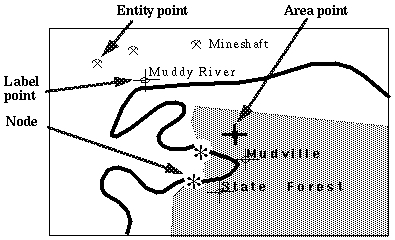
- Most primitive object is the POINT
- Can be (x,y) or (x,y,z)
- Consists of geocodes for location in a standard system
- Should be in world not image geometry
- If significant topologically, is a node.
- Can identify a feature (entity) or a label (label)
- Can be INSIDE an area and carry its identification information
One Dimensional Objects
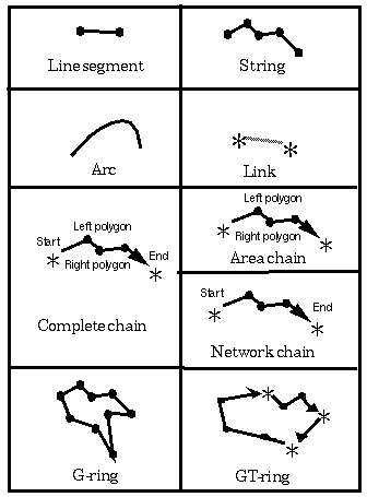
- Divide up by lines with and without topological significance
- Primitive object is the segment
- Segments connect to make a string (line or polyline)
- If defined mathematically, use arc
- If line segment connects nodes, called a link (for a network)
- Topological versions carry end node and or left and right polygon data
- Complete, area and network chain versions
- Area-like objects are G-ring and GT-ring
Two Dimensional Objects
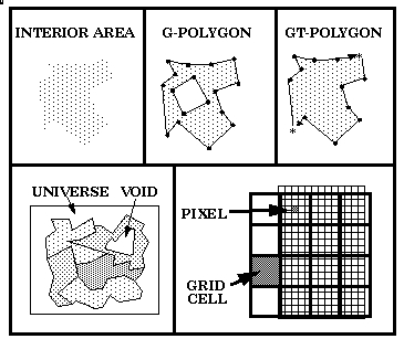
- Interior area is the space contained by the polygon, i.e. the object not
the boundary
- G-polygon contains graphical objects that form a polygon, e.g. a ring
- GT-polygon contains conplete topology
- Toplogical encoding requires universe and void polygons.
- Special objects
- pixel (the smallest non-divisible element of a digital image)
- Grid cell (same as pixel but for a grid)
Aggregate Objects
DIGITAL IMAGE
two dimensional array of regular pixels
GRID
Set of grid cells forming a regular or near regular tesselation
LAYER
- Areally distributed set of spatial data representing entity instances within
on theme, or with a common attribute.
- Usually registered with other layers.

RASTER
One or more overlapping layers from the same grid or digital image.
RED 
GREEN
BLUE 
GRAPH
Planar Graph: Node and link/chain set as applied to a plane surface
Two-dimensional Manifold: Planar graph with all included objects
Network: A graph without two-dimensional objects (links do not have to intersect)
Limitations
- Three dimensional objects
- time-sensitive objects
- Links to other standards e.g. PHIGS, GKS
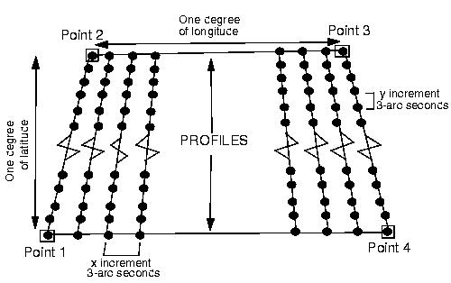
- Implementation slow via profiles
Keith C. Clarke Last Update 4/21/97 Copyright Prentice Hall (1995)