Beyond Surveillance
 
Next page | Previous page | Return to top of story

  fter the first successful launch in 1960, government
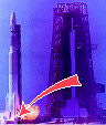
agencies realized there were massive civilian applications
reaching far beyond its original mission
.
 

Goleta Point from space.1:24,000 Quad revisions attributable to Corona input, 1977 Edition.
The systems worked so well that in short order the CIA was using Corona to map the world, remap the U.S., and to evaluate all 1:24,000 topographic maps for revision.

 
Archeological sites discovered in Corona imagery.
Archeological sites found - ruins of a Roman fort.
 
ARGON mosaic of Africa.
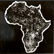
First high resolution image of Africa - a photomosaic of rectified ARGON photographs assembled around 1966. The original photomosaic was 80 feet by 60 feet.
 
Launch site.Geodetic marker at the launch site.Corona's geodetic marker in the World Geodetic System.  
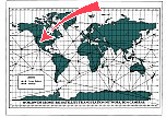
Creation of the World Geodetic System -
the geodetic network's "most important point".


Next page | Previous page | Return to top of story