Communicating Geographic Information in a Digital Age
Michael F. Goodchild
Abstract
The Biblical story of the Tower of Babel provides an allegory for the contemporary lack of interoperability among geographic information systems. Digital technology has been transformed over the past decade from dominance by applications that emphasize numerical processing to the facilitation of communication between people. Its introduction has had dramatic effects on the processes of production of geographic information, and on traditional roles such as that of the cartographer. Compared to the paper map, communication of geographic information by digital means removes numerous inherent constraints and opens an array of new opportunities involving new senses and representations. Discovery is presented as a form of communication, and the concept is updated in an exploration of the potential for new discovery. Digital Earth as conceived by Vice President Gore is a vision for communicating information, but it can also be seen as a solution to the problem of a user's search for geographic information among potential senders.
Introduction
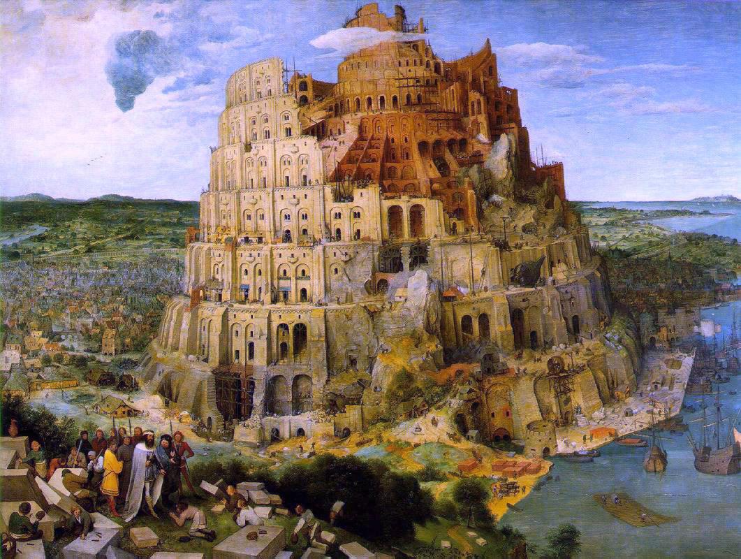
Peter Bruegel the Elder painted three versions of The Tower of Babel, but it is the middle version, painted in 1563 (Figure 1), which currently hangs in the Kunsthistorisches Museum in Vienna, that is perhaps best known. In it, Brueghel depicts events described in the 11th Chapter of the Bible's Book of Genesis. The people conceived of a project to build a tower so high it would reach to Heaven. The style is immensely detailed, and gives a fascinating account of such matters as European construction methods of the 16th Century. Early human society spoke one language, according to the story. The allegory becomes more compelling when one realizes that no one in the picture is holding a plan, or in any way controlling or coordinating the effort. There is a prince or a king, shown in the lower left, but he is facing away from the tower, and there is no indication of power over its construction or design. This is humanity united in a common purpose, and communicating through a common language—in the words of the King James edition, "and now nothing will be restrained from them which they have imagined to do" (Genesis, Ch 11 v. 6). God was displeased by the arrogance of the tower, punished humanity by making people unintelligible to each other, and scattered them "abroad upon the face of all the Earth".
This paper's major purpose is to examine communication from a contemporary perspective, using the case of geographic information. An observer might be forgiven for seeing God's punishment in post-modernism, or in the multiplicity of representations and formats used in the geographic information industry, and in the efforts now being expended by such organizations as the U.S. Federal Geographic Data Committee (www.fgdc.gov), the Open GIS Consortium (www.opengis.org), and the International Standards Organization to specify, harmonize, and standardize in the interests of greater interoperability (Goodchild et al., 1999a). GIS software has evolved largely in the absence of any widely accepted body of theory or concept, with each vendor adopting a distinct terminology and set of data format standards, and with each product forming the nucleus of its own information community. Transformations between standards are difficult, and large costs are incurred in retraining users from one system to another, or in coverting data. These barriers are likely to present major impediments as GIS databases become more important as ways of communicating geographic information.
The paper begins with a discussion of computing, and the paradigmatic changes that have occurred over the past few years, largely since the advent of the Internet and the World Wide Web (WWW). This is followed by sections on the communication of geographic information, and on the ways in which traditional arrangements have been impacted by the widespread adoption of digital technology. The paper addresses discovery, an activity intimately connected with the communication of geographic information, and discusses the nature of discovery in the digital age. Finally, Digital Earth provides the basis for a section on future technologies, and new metaphors for finding and communicating geographic information.
Geographic information and computing
Geographic information is defined here as information about the distribution of phenomena on the surface of the Earth (and the near-surface, and including). It has been formally defined by Goodchild et al. (1999b) as a well-defined subset of information in general, and as a commodity that is independent of the media on which it is stored, communicated, and used, and of the structures and models used to represent it. More loosely, the term refers to any information used to describe the surface of the Earth and the human activities that occur on it, and communicated from one person to another using terms, alphabets, media, structures, or formats that have meanings that are shared between the source of the information (the sender) and the recipient (the receiver). In the conceptual framework of classical information theory (Shannon, 1964), communication of geographic information results in a reduction in the receiver's uncertainty about the geographic world.
Computing technology entered the world of geographic information in the early 1960s, and one of its most significant impacts was the development of geographic information systems. Tomlinson (1998) describes the arguments that led to the wholesale adoption of computing technology in the development of the Canada Geographic Information System (CGIS), which is now widely acknowledged to have been the first GIS. The federal–provincial Canada Land Inventory had produced a large number of maps of current and potential land uses, and summary tables were needed showing the amount of land of various characteristics. To do this by hand would have required large numbers of employees using crude planimetric and transparent overlay techniques, and would have produced results of questionable accuracy. Computerization was shown to be much cheaper and more accurate, despite the high costs and limited capacities of computers at that time.
By emphasizing manipulation and analysis of data, the cost–benefit arguments for CGIS reflected a perception of computing that persisted from its earliest beginnings well into the current decade. Babbage and other computing pioneers (Wilkes, 1995) sought to invent machines that would relieve humans of the drudgery of calculation, and the motivation for computing's development during and after WWII was similarly related to the power of automated processing to provide numerical solutions to complex equations, and to decrypt enemy signals. GISs serve their users by performing several tasks that are difficult, tedious, unreliable, or labor-intensive when done by hand:
Once benefits can be seen to exceed costs based on these basic operations, economies of scale justify the computerization of many more forms of manipulation, including display and reformatting, and the use of GISs for support of spatial decisions in general (recent textbooks provide extensive reviews of GIS capabilities; see, for example, Burrough and McDonnell, 1998).
This view of GIS use reflects a prevailing metaphor of computer as processing engine, serving the needs of its user like a car or vacuum cleaner by delivering the ability to process large amounts of information, primarily numeric in nature, at high speed and low cost. Analysis is often presented as the driving force behind adoption of GIS, and cost–benefit evaluations modeled on Tomlinson's have been widely used to justify the introduction of GIS into government agencies, corporations, and academic institutions. The user is empowered through hardware (today's desktop workstation), software (a large integrated package such as ESRI's ARC/INFO), and data, integrated through the medium of the user interface.
Although the metaphor has served us well, it is severely challenged by the developments of the past decade, specifically the introduction of the World Wide Web and the role of the Internet. In this new environment, computing technology's primary function has become the mediation and facilitation of communication between people. Daniel Sui (1999) argues that GISs should now be viewed as media, or technologies that help senders to communicate geographic information in various forms to receivers, just as newspapers and television communicate more general forms of information. In this paper I term this the communication metaphor. In the words of Sun Microsystems, "the network is the computer", and data are merely the commodity exchanged between the network's users. Transformation and processing are still important but are now complementary to the primary function, occurring at various locations and at various stages during the process of communication, and adding value or revealing new insights where appropriate.
This conceptual transition is captured well by the ongoing debate over the relative importance of geographic information systems and geographic information services (Goodchild et al., 1999a). A user wishing to transform data, for example by replacing street addresses by geographic coordinates in the operation commonly known as geocoding, used to have only one option—to purchase GIS software to run in the user's workstation. Today, numerous WWW sites offer the function as a service, allowing the user to send a list of street addresses to the site over the Internet, and to receive in return the appropriate coordinates. In the GIServices model the database and software that support the geocoding operation remain in the server, and only the requests and results are communicated with the user or client.
One implication of a change of metaphor is that new parameters and issues become important, and begin to replace the traditional technical concerns of data storage capacity and processing speed, which were the motivating force behind early GIS research. The bandwidth (volume of data communicated per second) and latency (time taken for a message to travel) of communication, and the reliability of the communication channel, are now key constraints. So also is accessibility, since principles of equity of access to traditional media such as the mail appear not to have survived the transition to electronic networks, and access may have become less equitable since the advent of the Internet, rather than more. Communication is greatly impacted by questions of shared understanding, or what we would refer to technically as semantics, and these issues have now replaced earlier concerns with data structures and algorithms at the center of the geographic information science research agenda (Goodchild et al., 1999b; UCGIS, 1996)
Humans have evolved enormously sophisticated and varied methods of communication, using a range of senses (visual, auditory, tactile, olfactory), and a range of formal structures, from written text to imagery, maps, tables, and more recently relational databases. A key issue is the degree to which the communication channel facilitates interaction between humans or imposes itself on the communication process by constraining it through its own requirements of format, structure, medium, or precision. Communication by telephone supports many of the inherently vague conventions of human communication, including language and emphasis, while filtering out or removing aspects of gesture that can only be communicated visually. Communication by relational databases on the other hand imposes a rigorous formal structure on information, requiring everything to be expressed in the form of rectangular tables that may be linked to each other by common keys (Date, 1975), and being hostile to anything that cannot be so expressed. This tendency for technology to filter communication has been one of the major concerns of the recent critique of GIS (see, for example, Pickles, 1995).
Consider, for example, the geographic message "it is cold here". The telephone allows the message to be transmitted intact, as do text-based channels such as electronic mail. A GIS database is much more intrusive, however, since it requires the user to transform "here" into a precise statement of location, and may also require "cold" to be transformed into a precise statement of temperature. Such transformations between the vague world of human cognition and reasoning and the precise, formalized world of GIS databases raise many important research issues, and have been the subject of much research (for a review of cognitive research in geographic information science see Mark et al., 1999). In the world of the computer as the scientist's processing engine, it was possible to assert that computers should not be used for vague purposes, and that users should formalize information before submitting it to processing. "It is cold here" should be transformed into a precise statement about temperature and location before anything useful could be done; and if it could not, it was not worth communicating. But in the world of computer as human communication medium, the question of whether information should be forced to adapt to the nature of the channel is much more debatable.
The digital transition
To communicate by analog means, there must be a channel capable of sending messages that incorporate signals of varying magnitude, and sender and receiver must agree on the relationships between magnitudes in the message and magnitudes in reality. For example, the telephone works because electrical signals sent over copper wires are proportional to the air pressure variations caused by speaking, and the earpieces of telephones allow them to be transformed back to air pressure variations to be heard by the receiver. Maps work because distances on paper are approximately proportional to distances on the ground. In digital communication, sender and receiver must further agree on a code that is used first to express message content in a fixed alphabet, and then to decode it; but the channel need only be capable of transmitting messages expressed in the alphabet. Digital communication has obvious advantages: it is precise, because the alphabet is discrete; a restricted alphabet allows the communication channel to be very simple; and error-detection strategies can be used to ensure that communication is virtually error-free. Over the past 50 years a suite of standards has been developed that allows virtually all forms of human communication to be expressed in the simplest possible alphabet, as combinations of 0s and 1s. They include standards for speech that are used by digital telephone networks, music (CD standards, MIDI), pictures and images (JPEG, GIF, TIFF), text (ASCII), and geographic data (FIPS 173, DIGEST). The binary alphabet is already so dominant that its use has become synonymous with digital, despite that word's historic association with the human body and base 10.
The pervasiveness of digital technology is due in part to the economies of scale that can be achieved once it is agreed that all forms of communication should use the same alphabet. A packet of bits sent over the Internet under the TCP/IP protocol might represent speech, text, a picture, or a map, but the distinction is irrelevant to the technology used to transmit and store it. Only the sender and receiver need to share details of the coding scheme, in order for the receiver to be able to reconstruct and understand the content. Digital technology is expected to become far more prominent in the future, because of further improvements in the key parameters—bandwidth, storage volume, and processing speed—at costs that are expected to continue to fall.
The impacts of the digital transition on communication of geographic information can be seen in the simple example of geologic mapping, illustrated in Figure 1. In an idealized world that may or may not have existed in some past golden age of thematic cartography, information about the geology of an area was communicated in the following way. A field geologist worked over the area in detail during the field season, collecting information in the form of notes and sketches. These were given to a cartographer, who compiled a complete picture of the area in the form of a geologic map. Geologist and cartographer may have spoken directly, and may have been the same person, but in the worst case all of the geologist's knowledge would have had to pass through the medium of notes and sketches. The cartographer passed a compiled product to the printer in the form of separates, and the printer passed the information to the distributor in the form of a printed map. Finally, the distributor passed the information to users, collectors, and librarians. Each medium—sketches and notes, separates, and paper map—imposed its own possibly unique requirements and constraints on the communication channel.
The first impact of the digital transition was in the cartographic production process. Computing technology began to change the process of map compilation, drafting, and editing in the late 1960s, as mapping agencies found that editing of maps in digital form could be far faster and more cost-effective than expensive redrafting. By the mid-1970s the user community was beginning to realize the advantages of working with data in digital form, and began to demand data on magnetic tapes as an alternative to the conventional paper distribution. Although the printer could now be bypassed, the information communicated in digital form was essentially unchanged from the content of paper maps. In the early 1990s, the Internet began to offer a much faster channel of communication than magnetic tapes or CDs, and the advent of spatial data clearinghouses and large-scale data archive centers allowed the distributor to be bypassed.
Two more fundamental changes are in progress. The channel between the field geologist and the cartographer is likely to be strongly impacted by new field technologies, such as GPS, digital cameras, low-cost satellite imagery and aerial photography, and hand-held computer mapping systems. As it has at other points in the flow diagram, information technology in the field has the potential to lower cost, increase the amount of data gathered, and increase the width of the communication channel by supporting new forms of representation. It may even blur the distinction between geologist and cartographer by allowing one person to perform both functions. Finally, the investments that are now being made in digital libraries, new search mechanisms (NRC, 1999), and metadata are directed at making it easier to find geographic data in the massive, distributed archives of electronic networks. These points are explored in greater detail below.
As with many other instances of technology, the first impacts of the digital transition were felt at points in the production and dissemination of geographic information where existing operations could benefit the most, through reductions in cost or improvements in speed or efficiency. But in the longer term, new technology is changing the nature of the process, merging or redefining stages, and inventing new ones. To predict the effects of technology successfully, therefore, it is necessary to ask what basic function the system performs that is independent of technology, and invariant under its changes. The system shown in Figure 1 exists to communicate geographic information, and in the long term will adopt whatever form is most effective and efficient at achieving that fundamental objective.
Signs of the long-term impacts of the digital transition are already becoming apparent in new social and institutional arrangements. Cartographic software is now cheap and affordable, and new data collection systems are providing massive amounts of data at low cost. In precision agriculture, farmers are able to afford and use acquisition systems attached to tractors and harvesters, and to make decisions based on geographic information that they have collected at resolutions far greater than anything traditionally supplied by national mapping agencies. The economies of scale that justified concentration of map production at the national level in agencies such as the U.S. Geological Survey no longer obtain. Instead, the future of map production is argued to lie in a patchwork of cooperative arrangements between agencies at all levels, defined by models such as the National Spatial Data Infrastructure (NRC, 1993). Systems of central production and radial dissemination of geographic information that evolved in an era of high fixed costs and massive economies of scale are now being challenged by systems of very low fixed costs that emphasize local production and networked dissemination.
Beyond the map
If the true impact of the digital transition lies in the way it enables new forms of communication, and leads to the restructuring of arrangements and institutions, then one might usefully ask what its impact will be on the traditional medium for communicating geographic information, the printed map; on the role of the cartographer; and on cartographic institutions. The previous section examined the process of map-making; this section looks at the problem of communicating geographic information in general, and the opportunities that are afforded by a communication channel that can support any representation that is expressible in 0s and 1s.
As a communication channel, the map is limited by eight constraints, all of them imposed to some extent by the medium and removed to varying degress by digital communication. First, the map must of necessity use the visual sense, whereas all five senses are potentially available for communication (and interesting and effective use has been made of the tactile sense; Coulson, 1991). Second, the map must be flat, whereas nothing in the digital communication channel forces projection to a plane. Third, the need for an approximately uniform scale ensures that a map provides a single level of detail, except where insets provide more. A digital communication channel can support multiple levels of detail (Weibel and Dutton, 1999) as well as spatial or temporal variation in level of detail. Fourth, a map is static, being difficult to change or transform once printed. Digital data can be updated constantly by database transactions, so that users accessing a single source can be assured of current data, or transformed by computer operations. Fifth, map production is driven by strong economies of scale to satisfy the requirements of large numbers of users, and to select products that serve as many purposes as possible. Digital data can be produced, transformed, and communicated at much lower fixed costs, and thus digital communication is more favorable to user-centered perspectives and customized data production. Sixth, economies of scale have also driven the convention that a map should be exhaustive of the area within its boundaries, whereas the lack of such economies in digital communication makes patchwork mapping more feasible. Seventh, the information shown on maps is precise, and few methods exist for displaying uncertainty. Researchers have explored many methods for communicating uncertainty through the digital channel (see, for example, Goodchild and Jeansoulin, 1998). Finally, map production is slow, whereas the digital channel is limited in principle only by the velocity of light, though in practice it is also limited by capacity.
Institutions and professions have evolved over the centuries in response to many needs and priorities, and it is common for many functions to be combined somewhat confusingly in a single profession. Thus the cartographer, for example, is not only the holder of the pen, but also the designer of the map and the arbiter of quality. When one of these functions is automated, or the need for it removed by changing economics, it is easy to believe that the profession is threatened. Computerization is killing cartography in the sense that it is automating and changing various aspects of the production and dissemination functions, and may even be challenging the primacy of the map as a means of communicating geographic information. But the digital transition does not remove the need for cartography's design and quality control functions, which remain as important in the digital era as they were before. Hence the digital transition presents the profession of cartography with a paradox. Map-making has been profoundly affected by the advent of digital technology, which has made it possible for anyone equipped with data and a simple mapping package to make a map. The professional map-maker has been marginalized, since it is no longer necessary to belong to the profession to make maps. But at the same time the digital transition makes the training of the cartographer in design and quality control more important than ever, and the consequences of poor design are readily apparent in any collection of GIS displays.
Discovery and communication
The Age of Discovery describes the period beginning in the 15th Century that was characterized by voyages of exploration from Europe, rapid expansion of European domination over the rest of the world, and the first efforts at world mapping according to modern cartographic standards of planimetric accuracy. Henry the Navigator (1394–1460; Figure 3) is often credited with initiating the Age of Discovery, and with Portugal’s early dominance, through his efforts to finance exploration, and to establish a school at Sagres where he gathered cartographers, navigators, and other experts.
The actual discoveries of Henry’s lifetime were modest: they included the Cape Verde Islands, which redefined the westernmost limits of the known world, and the coast of West Africa as far as Sierra Leone. The great discoveries came in the years after his death, with the voyages of Da Gama, Diaz, and Columbus, but Henry clearly laid the foundation, particularly through the notion of discovery as a collective, scientifically motivated endeavor, in which economic gain was strictly secondary, and in which the economic value of secrecy was outweighed by the collective value of sharing information (Ure, 1977; though for a contrary view see Martins, 1901, or Godinho, 1962).
Exploration and discovery are traditionally seen as activities involving the human explorer and the place explored—for any place, the explorer is defined as the first human to visit that place. Henry rarely explored, being content to plan and finance expeditions in his name. His key innovation, however, was in ensuring general access to geographic information, and in fostering a sense of common ownership of results, characteristics that we now associate with science. In this perspective a third element becomes important to exploration—the receiver of the information—and discovery is defined as a reduction in the receiver’s uncertainty about the world through the actions of an explorer as sender of information. In this view, as in the scientific community generally, it is assumed that information always reaches all receivers, and information would not qualify as a discovery if it was already known to one, and therefore to all. Of course it is this assumption of universal access to information that has allowed the communication aspects of discovery to be largely ignored.
The Age of Discovery is normally considered to have begun with Henry, and to have ended when the last blank areas on the map of the world were filled. This view has several fundamental flaws, however. First, most of the world’s land area was already occupied by humans long before Henry, though simple occupancy fails the test of discovery if geographic information about it could not be communicated widely. Much of the land area had also been visited by Europeans, and communicated to European audiences. Although the Portuguese reached India in 1498 during the golden era of the Age of Discovery, Christianity had reached the coast of South India over 1200 years before, and Alexander the Great had invaded India in 325 BC. But in the Age of Discovery information was communicated across the European world, through the medium of the newly invented printing press, and added to the cumulative, integrated store of European knowledge to which all Europeans in theory had access.
Second, the notion of discoverer begs an important question of scale, and the relationship between the location of the explorer and the area that is said to have been explored. There will always be areas of the Earth’s surface where human feet have never trod, or that human eyes have never seen; there will always be geographic information that has not been communicated to any receiver; and there will always be humans who have not received all geographic information. This suggests a modern view of discovery, or rediscovery, that is consistent with the theme of communication of geographic information. The following sections present four different views of what discovery might now mean. In sequence, they challenge the traditional model by suggesting that the process of discovery as communication of geographic information (1) need not reach all receivers, (2) need not require the sender to be colocated with the subject of the discovery, (3) cannot exhaust the information potentially communicable about a place, and (4) can be more effective in its acquisition of information.
Personal discovery
Caves are one of the few areas of the planet where there is still the opportunity for discovery in the traditional sense. Curl (1986) has described caves as fractals, and explored the relationship between the volume of cave that is explorable by a virtual caver, defined as a sphere of a given radius, and the radius of the sphere. A cave that has been previously explored almost always shows evidence of previous entry, in the form of footprints, smudges where bodies have dragged themselves, bolts used to secure climbers, or marks made for surveying, leaving Taylor (1997) to describe caving as "unique in the way it destroys its own environment" (p.8).
Prior to 1970 it was common practice for cavers to publish both cave maps and the locations of entrances (e.g., Bretz, 1956). Since then, the negative consequences of caving have led to a reversal of practice. Information is no longer published and collective, but shared largely among friends, and the caving world has fragmented into a number of distinct information communities. The receiver of information must now be an explicit part of the discovery process, since discovery for one is no longer necessarily discovery for all. The same cave passage may now be rediscovered repeatedly, as information is communicated to new receivers and new information communities, or as new explorers reënter areas that have been visited before. Tierney (1998) has coined the term explornography for "the vicarious thrill of exploring when there’s nothing left to explore."
This interpretation of discovery is problematic for science, of course, which is about collective rather than personal discovery. Can discovery be scientific if its results cannot be communicated to all? Is there any scientific value in rediscovery, or the discovery of information that is already known to others? If communication in the scientific community has become imperfect, then is it ever possible to know with certainty whether information is truly new?
Virtual discovery
Henry the Navigator was in a sense a virtual discoverer, never setting foot on many of the lands discovered under his direction. Wood (1996) has suggested that Marco Polo may have been a virtual discoverer also, and research based on secondary data is of course also a form of virtual discovery. Today, remote sensing and aerial photography allow extensive and detailed discovery without physical presence, and we are encouraged to believe that "there is no more there, everywhere is here" (Negroponte, 1995). The Internet and Hollywood offer to deliver the world to our desktops and living rooms, making virtual tourists and discoverers of us all.
Recently, U.S. Vice President Al Gore has outlined his vision of a Digital Earth (DE) as a futuristic form of virtual discovery. In the text version of a speech delivered in Los Angeles, he describes "a multi-resolution, three-dimensional representation of the planet, into which we can embed vast quantities of georeferenced data" (see http://www.opengis.org/info/pubaffairs/ALGORE.htm). It is an immersive environment through which a user, particularly a child, could explore the planet, its environment, and its human societies. It might be available at museums or libraries, and a more modest version might be available through standard WWW browsers running on a simple personal computer. Further implications of the concept are discussed in a subsequent section.
Finding more
As noted earlier, the traditional concept of discovery begs an important question of scale. The geographic world is infinitely complex, and any geographic information must necessarily approximate or generalize to some degree. From this perspective there is always the potential for discovery, in gathering and communicating information that is more detailed than before, or more accurate, or that deals with a new or different theme. It matters little whether a human has set foot at or near a location, since there is always the potential for new information to be gathered and communicated.
Acquiring more efficiently
As noted earlier, the traditional concept of discovery has a definitional flaw: it is not clear whether viewing a place is sufficient, or whether the discoverer must be physically present at the place. Clearly viewing from afar was sufficient to discover the moon, but not to explore it, whereas Lewis and Clark were physically present at only a very small fraction of the places they discovered and explored for the U.S. Government. Modern technologies allow us to acquire far more information than could previously be recorded in notebooks or in the human mind. Early information technologies such as the mainframe could operate only in certain carefully controlled environments, and were immobile. But today's technology is increasingly itinerant, in the sense that it can be moved anywhere and used while in motion; and ubiquitous, in the sense that it is available everywhere. Whereas the virtual world has been presented as an alternative to the real world, and limited because of the fundamental limitations to its representations, it is now possible to think of technology augmenting the interaction between human and geographic reality. Field technologies are capable of augmenting perceived reality with previously collected data, or of enhancing human perception by extending sensory capabilities (e.g., infrared binoculars), thus greatly extending the geographic information that the human sender is able to communicate.
Communicating through Digital Earth
While elements of Vice President Gore's vision are possible with today's technology, the technical demands of his proposal are massive. Today's display devices have resolutions on the order of 1000 by 1000, or 1 million picture elements, and an image of the Earth that fills the screen has an effective resolution of about 10 km. To create a reasonably detailed image of a neighborhood would require a resolution of no more than 1 m, so DE would have to be capable of zooming over at least 4 orders of magnitude. Coverage of the entire Earth at 1 m resolution requires on the order of 1015 picture elements, and if the description of the contents of each one requires 1 byte of data then DE must handle no less than a petabyte, or 1015 bytes, which is well beyond the storage capacity of any current device and by repute approximately equal to the entire contents of all of the world's WWW pages. It would take approximately 104 years to download a petabyte of information through a standard modem. Moreover, there are interesting cartographic research problems in being able to generalize geographic data over 4 orders of magnitude, and in finding appropriate ways of displaying variables that are not easily rendered, such as social, economic, and health indicators.
Nevertheless, DE raises questions and possibilities that go far beyond the technical. While discovery often ties a place to a person, there is no such implicit tie between a place and sources of geographic information about that place. Information about a geographic location might be found on servers maintained by any level of government, or by individuals, corporations, or academic institutions. There are order 107 servers connected to the Internet, and in principle any one of them might contain relevant information about a given place. Push technologies such as electronic mail are capable of directing information from a sender to any receiver; but to pull information requires that the receiver first identify a suitable source.
In the traditional library the catalog provides the solution to the problem of information pull, by making it possible for the receiver to identify a source with reasonable efficiency. Search was not a problem in the world of central map production, because maps were necessarily available from only a very few sources. But it is estimated that only 10% of WWW pages are cataloged, in the sense of being accessible through any of the search engines (Lycos, Yahoo, Altavista, Excite, Hotbot, etc.). Moreover, all of these engines use some form of keyword search, whereas the primary basis for searching for geographic information is location, a property that is difficult to express effectively in words. While some 20 million WWW pages are found by a search on "map" (Rhind, 1999), there are few effective mechanisms for searching the vast resources of the WWW for geographic information.
In this context, DE provides an interesting vision for new ways of organizing geographic information. The dominant metaphor for searching in a library is the card catalog, and on the WWW it is the keyword. The metaphor for organizing computer interfaces is the office or desktop, and operating systems present the world as if it were structured according to the familiar artifacts of the office: clipboard, filing cabinet, folder. DE, on the other hand, has the potential to provide a much more natural and satisfactory metaphor for organizing geographic information, by presenting it arrayed on the surface of the Earth. Icons located on a rendering of the surface could be used to express the presence of information, and expanded by the user's pointing and clicking. Early implementations of this idea can already be seen in the Economist screensaver (www.economist.com), and in Microsoft's Encarta atlas, as well as in numerous other products and services.
Within the communication paradigm that is the focus of this paper, DE addresses the most recent variant: the generalization of the identity of sender. A postmodern world requires us to generalize the concept of receiver, because not all information is available to all. It also forces us to generalize the concept of sender, because the old certainties—a single discoverer for all places, a single source for all maps—no longer hold. It leaves unresolved a third issue, however, which is the requirement that for effective communication both sender and receiver must either belong to the same information community, or invest in mechanisms of translation. Whether technology will be able to make any progress in addressing this issue remains to be seen.
Concluding comments
This paper has been driven by the observation that computing is now dominated by a paradigm of human communication, and that the old metaphor of processing engine no longer explains the very rapid growth in the adoption and use of computing technology. While computers used to help individuals do their work, they now help pairs of individuals and entire communities to communicate. Processing has become incidental—used to add value at various stages in the exchange of information, by transforming or analyzing to reveal new insights or to serve new purposes. This is not to say that processing is not still important, of course, particularly in the research enterprise, or that analysis should not continue to be taught as a very important role for GIS.
It follows that the concept of information must be generalized to include all information that is usefully passed between people, including information that has traditionally been thought to be unscientific, vague, or subjective. The problems of handling such information in precise computing systems are an important part of the research agenda, which must address questions of storage, display, query, and user interface design.
Because of fundamental changes in the economies of scale of geographic information production and handling, it is now no longer necessary to confine production to large central facilities, and it is becoming increasingly hard to identify a suitable source of a given item of geographic information. Lack of operable search mechanisms has become a major problem to the effective communication of geographic information over the largely uncataloged WWW.
There are two distinct phases in the story of the Tower of Babel—before and after God became angry. Much of the rhetoric associated with information technology in the 1990s has suggested the former phase, of an Internet that needs little imposed structure other than the TCP/IP protocol, because its users share a common sense of creative purpose. But some aspects of the Internet suggest the second phase: of increasing inequities of access, sharply differentiating the haves and have-nots; of information communities unable to communicate because of a lack of shared standards; of an information resource that is as useless as the stacks of an uncataloged library; and of information whose quality can never be assured. The Internet is a recent phenomenon, so it is reasonable to ask whether these problems are innate, and whether they must necessarily worsen, or whether they are the temporary consequence of rapid technological development.
The Vice President's text clearly evokes the earlier phase of the story. Equity of access would be assured, at least nationally, by locating DE sites in public spaces such as museums, and by funding them at public expense. The problems of interoperability would be dealt with by establishing and adopting a uniform reference model or specification for DE, based on sound theory, perhaps through the work of the Open GIS Consortium. Problems of search would be overcome through the development of a new generation of WWW search engines or adoption of common catalog specifications. Metadata would include adequate descriptions of quality, and other assurance mechanisms such as quality testing services would be implemented. All of these issues are parts of the active research agenda of the GIS community as we enter the new millennium, and only the most hardened skeptic would deny the likelihood of progress.
DE would even support a contemporary view of geographic discovery. The information available through DE could be updated constantly as the geographic world changed, or as new acquisition systems added to the collective store of data. Users could be supported in the creation of personal archives that reflected what they as individuals had discovered or considered important, either as extracts from the collective archive of DE, or as information individually acquired in the form of travel photographs or diary accounts.
There are two phases in the story, and the second comes chronologically after the first. But the vision of DE clearly implies a belief that the phases can be reversed—that human will can overcome problems of lack of interoperability, through cooperative research and development. DE is a new Tower of Babel, to be created by a conscious effort to overcome problems of communication, rather than a cause of those problems. As such, it seems an admirable goal for geographers in the new millennium.
Acknowledgment
This paper is based on a keynote presentation to the International Cartographic Association's 11th General Assembly in Ottawa in August 1999. I am grateful to John Pickles and David Rhind for the rebuttals they prepared to the preconference version (Goodchild, 1999; Pickles, 1999; Rhind, 1999a), to subsequent discussions with Francis Harvey, and to Daniel Sui's sharing of his ideas of GIS and media. The paper also draws on ideas included in a keynote presentation at GISPlanet 98 in Lisbon (Goodchild, 1998).
References
Bretz, J.H. (1956) Caves of Missouri. Rolla, MO: State of Missouri, Division of Geological Survey and Water Resources.
Burrough, P.A., and R.A. McDonnell (1998) Principles of Geographical Information Systems. New York: Oxford University Press.
Coulson, M.R.C. (1991) Tactile-map output from geographical information systems: the challenge and its importance. International Journal of Geographical Information Systems 5(3): 353–360.
Curl, R.L. (1986) Fractal dimensions and geometries of caves. Mathematical Geology 18(8): 876–784.
Date, C.J. (1975) An Introduction to Database Systems. Reading, MA: Addison-Wesley.
Godinho, V. Magalhães (1962) A Economica dos Descobrimentos Henriquinos. Lisbon.
Goodchild, M.F. (1998) Rediscovering the world through GIS. Proceedings, GISPlanet 98, Lisbon, September. CD.
Goodchild, M.F. (1999) Cartographic futures on a digital Earth. Proceedings, International Cartographic Association Assembly, Ottawa, August. CD.
Goodchild, M.F., M.J. Egenhofer, R. Fegeas, and C.A. Kottman, editors (1999a) Interoperating Geographic Information Systems. Norwell, MA: Kluwer Academic Publishers.
Goodchild, M.F., and R. Jeansoulin (1998) Data Quality in Geographic Information: From Error to Uncertainty. Paris: Editions HERMES.
Goodchild, M.F., M.J. Egenhofer, K.K. Kemp, D.M. Mark, and E.S. Sheppard (1999) Introduction to the Varenius project. International Journal of Geographical Information Science 13(8).
Mark, D.M., C. Freksa, S.C. Hirtle, R. Lloyd, and B. Tversky (1999) Cognitive models of geographic space. International Journal of Geographical Information Science 13(8).
Martins, J.P. Oliveira (1901) Os Filhos de D. João I. Lisbon.
National Research Council (1993) Toward a Spatial Data Infrastructure for the Nation. Washington, DC: National Academy Press.
National Research Council (1999) Distributed Geolibraries: Spatial Information Resources. Washington, DC: National Academy Press.
Negroponte, N. (1995) Being Digital. New York: Knopf.
Pickles, J., editor (1995) Ground Truth: The Social Implications of Geographic Information Systems. New York: Guilford.
Pickles, J. (1999) Cartography, digital transitions, and questions of history. Proceedings, International Cartographic Association Assembly, Ottawa, August. CD.
Rhind, D.W. (1999a) Business, governments, and technology: inter-linked causal factors of change in cartography. Proceedings, International Cartographic Association Assembly, Ottawa, August. CD.
Rhind, D.W. (1999b) Keynote presentation, International Cartographic Association Assembly, Ottawa, August.
Shannon, C.E. (1964) The Mathematical Theory of Communication. Urbana: University of Illinois Press.
Sui, D.Z. (1999) GIS as media? Or how media theories can help us understand GIS and society. In E. Sheppard and R. McMaster, editors, GIS and Society: An International Perspective (forthcoming).
Taylor, M.R. (1997) Cave Passages: Roaming the Underground. New York: Vintage.
Tierney, J. (1998) Explornography. The New York Times Magazine (July 26), pp. 18–23, 33–34, 46–48.
Tomlinson, R.F. (1998) The Canada Geographic Information System. In T.W. Foresman, editor, The History of Geographic Information Systems: Perspectives from the Pioneers. Upper Saddle River, NJ: Prentice Hall PTR, pp. 21–32.
University Consortium for Geographic Information Science (1996) Research priorities for geographic information science. Cartography and Geographic Information Systems 23(3): 115–127.
Ure, J. (1977) Prince Henry the Navigator. London: Constable.
Weibel, R., and G. Dutton (1999) Generalising spatial data and dealing with multiple representations. In P.A. Longley, M.F. Goodchild, D.J. Maguire, and D.W. Rhind, editors, Geographical Information Systems: Principles, Techniques, Management and Applications. New York: Wiley, pp. 125–155.
Wilkes, M.V. (1995) Computing Perspectives. San Francisco: Morgan Kaufmann.
Wood, F. (1996) Did Marco Polo Go to China? Boulder, CO: Westview Press.
Figure 1. The Tower of Babel (1563), by Peter Brueghel the Elder.
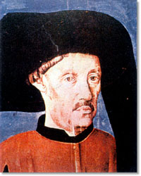
Figure 3. Prince Henry the Navigator, 1394–1460.