Spatial data infrastructure
what is it?
why was the concept invented?
national programs
international efforts
the private sector
1992
$5 billion annual federal expenditures on geographic information (GI)
not including remote sensing programs of NASA
"There is no national policy covering spatial data nor is there a national organization or agency with the charter, authority, and vision to provide leadership of the nation's spatial data collection, use, and exchange"
"Because of the lack of central oversight, there appears to be extensive overlap and duplication in spatial data collection at the federal level. Overlap in data collection also appears to occur between federal and state agencies, and among state, local, and private sector organizations, all at a significant cost to the public. These institutions are collecting spatial data at many scales, levels of accuracy, levels of detail, and categories of data, making the sharing of spatial data very difficult (if not impossible)"
"There are no current mechanisms that allow identification of what spatial data have been collected, where the data are stored, who controls access to the data, the content of the data, and the data coverage (e.g., scale, data density)"
"Although a Federal Information Processing Standard (FIPS) for spatial data transfer has been approved, profiles for implementing this standard for the exchange of data between federal agencies have yet to be developed. Moreover, standard activities need to be expanded beyond transfer standards to include more specific measures and standards of content, quality, currency, and performance of various components of the NSDI. As a corollary, there is no agreed-upon representation of "base data" for small-, medium-, and large-scale spatial data products"
"There are major impediments to, and few workable incentives for, the sharing of spatial data among the federal, state, and local organizations"
Mapping Science Committee
a committee of the National Research Council
the operating arm of the National Academies
National Academy of Sciences
National Academy of Engineering
Institute of Medicine
Goodchild, Clarke have both chaired the MSC
"Toward a Coordinated Spatial Data Infrastructure for the Nation"
published in 1993 by National Academy Press
basic issues
lack of sharing
lack of interoperability
turf, ownership
make rather than buy
duplication
is that necessarily a bad thing?
yes when it's taxpayers' money?
lack of coordination
no one in charge
general decline in national mapping programs
peaked in 1960s
average USGS map now 30 years out of date
move in many countries to make users pay
US federal government cannot copyright
scale economies
traditionally high fixed costs
low marginal costs
make lots of copies of few maps
make generic maps to satisfy lots of purposes
by early 1990s anyone could make a map
with $2k computer and $1k software
$100 GPS
Internet connection
precision agriculture
use of GIS, GPS, remote sensing to manage fields
detailed mapping
sensors on plows, harvesters
imagery
real-time variation in rate of application
fertilisers
pesticides
reduce cost, increase yield
reduce environmental impact
farmers have detailed digital maps of fields
soil type, yield, moisture
compare federal soil services
Natural Resources Conservation Service
formerly the Soil Conservation Service
STATSGO
1:250,000 source
2500 acres minimum mapping unit
SSURGO
1:12,000 or 1:24,000 source
1-10 acre minimum mapping unit
sub-field
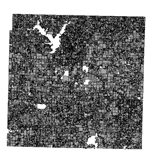
soil map for South Coast
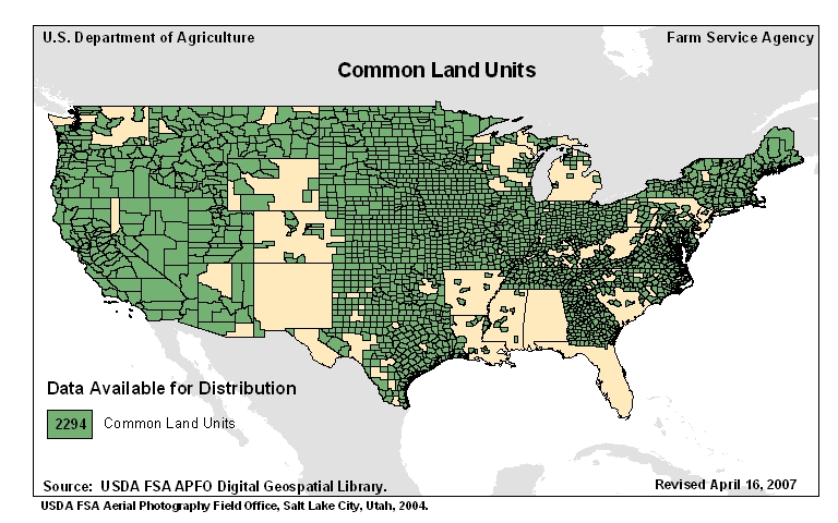
common land units
"A Common Land Unit (CLU) is the smallest unit of land that has a permanent, contiguous boundary, a common land cover and land management, a common owner and a common producer association"
many farmers now have better data than the federal agencies can provide
a potential source for federal agencies
quality control issues
similarly many local governments, states
old model of central production, radial distribution breaking down
being replaced by a network model
many agencies are both suppliers and consumers
recommendations
Federal Geographic Data Committee
staffed by Dept of Interior
chaired by Secretary
federal role becomes coordination
standards
funding
signed by President Clinton April 11 1994
National Geospatial Data Clearinghouse
evolved into the Geospatial One-Stop
an element of data.gov
standards
metadata
common classification schemes
wetland mapping
framework data
partnerships
with states, locals, private sector
framework data
layers that serve as common reference
other information referenced to them
used as registration points
readily visible on the ground
each layer with a lead agency
foundation data
Geodetic Control
National Geodetic Survey
Cadastral
Bureau of Land Management
parcels as building blocks
Orthoimagery
US Geological Survey
Elevation
US Geological Survey
Hydrography
US Geological Survey
Administrative Units
US Census Bureau
Transportation
Department of Transportation
what's missing?
Since 1992
successful program
copied worldwide
three issues
Metadata
why make the effort?
documentation
useful later
useful for others
the more distant, the more metadata are needed
distant in space and culturally
metadata are expensive and tedious to create
is the current standard sufficient?
granularity
standard addresses data sets
not geodatabases
quality
emphasis on absolute not relative
TFL
need for binary metadata
will these two data sets work together?
standard is producer-centric
what the producer knows, not what the user needs
a TripAdvisor for GIS data?
Why share?
my county GIS is working just fine
why should I share with anyone?
vertical
share upwards in the hierarchy
unfunded mandates from state and federal
horizontal
edgematching
TFL
sharing is more likely over shorter distances
NSDI is federal
why should state, local, private sector participate?
world of Google Earth is predominantly private
private sector is better resourced
orders of magnitude more staff, funding
Open Geospatial Consortium
government/private/academic partnership
successful development of standards
WMS, KML, GML, ...
active in internationalization of standards
metadata standard in ISO
ISO 19115
International perspectives
GSDI
an active organization promoting SDI concepts worldwide
by 2001 59 countries had implemented national clearinghouses
e.g. overcoming differences in Europe
INSPIRE