About Myself
My name is Gengchen Mai, a Ph.D. candidate at Space and Time for Knowledge Organization Lab, Department of Geography, University of California, Santa Barbara. My Ph.D. adviser is Prof. Krzysztof Janowicz. I am interested in Machine Learning/Deep Learning, Geographical Information Science (GIScience), Geographic Question Answering, NLP, Geographic Information Retrieval, Knowledge Graph, and Semantic Web. Right now, my research is highly focused on Geographic Question Answering and Spatially-Explicit Machine Learninig models. I have completed four AI/ML research based internships at Esri Inc., SayMosaic Inc., Apple Map, and Google X.
Before I become a MA/Ph.D. Student at UCSB, I got my B.S. Degree in Geographic Information System from Department of Geographical Information Science, School of Resource and Environmental Sciences, Wuhan University. During my undergraduate study, my research topic, especially undergraduate thesis, is focused on Land Use/Cover Change (LUCC), spatial analysis and spatial statistics.
I am currenly on the Job market and open to full-time positions starting from July 2021.

Research Interests
- Spatially-Explicit Machine Learning
- Geographic Question Answering
- Nature Language Processing
- Geographic Information Retrieval
- Machine Learning/Deep Learning
- Knowledge Representation
- GIScience
- Spatial Data Mining
- Spatial Statistic/Analysis
- Geo-ontology Engineering
Contact
Gengchen Mai
Address:
4829 Ellison Hall
University of California, Santa Barbara
Santa Barbara, CA 93106, USA
Email:
See Also:
Education
Doctor of Philosophy
Time:
12/01/2017 – Present
Institution:
UC Santa Barbara, Santa Barbara, CA, USA 93106
College:
Department:
Lab:
Major:
Cartography and GIS
Adviser:
Committee Member:
Prof. Krzysztof Janowicz (Chair), Prof. Werner Kuhn, Prof. Kostas Goulias
Master of Art
Time:
09/24/2015 – 11/31/2017
Institution:
UC Santa Barbara, Santa Barbara, CA, USA 93106
College:
Department:
Lab:
Major:
Cartography and GIS
Adviser
Committee Member:
Prof. Krzysztof Janowicz (Chair), Prof. Werner Kuhn, Prof. Kostas Goulias
Bachelor of Science
Time:
09/04/2011 – 06/30/2015
Institution:
Wuhan University, Wuhan, Hubei, China 430079
Department:
Department of Geographical Information Science
Major:
Geographic Information System
Adviser:
Prof. Shiliang Su
Thesis:
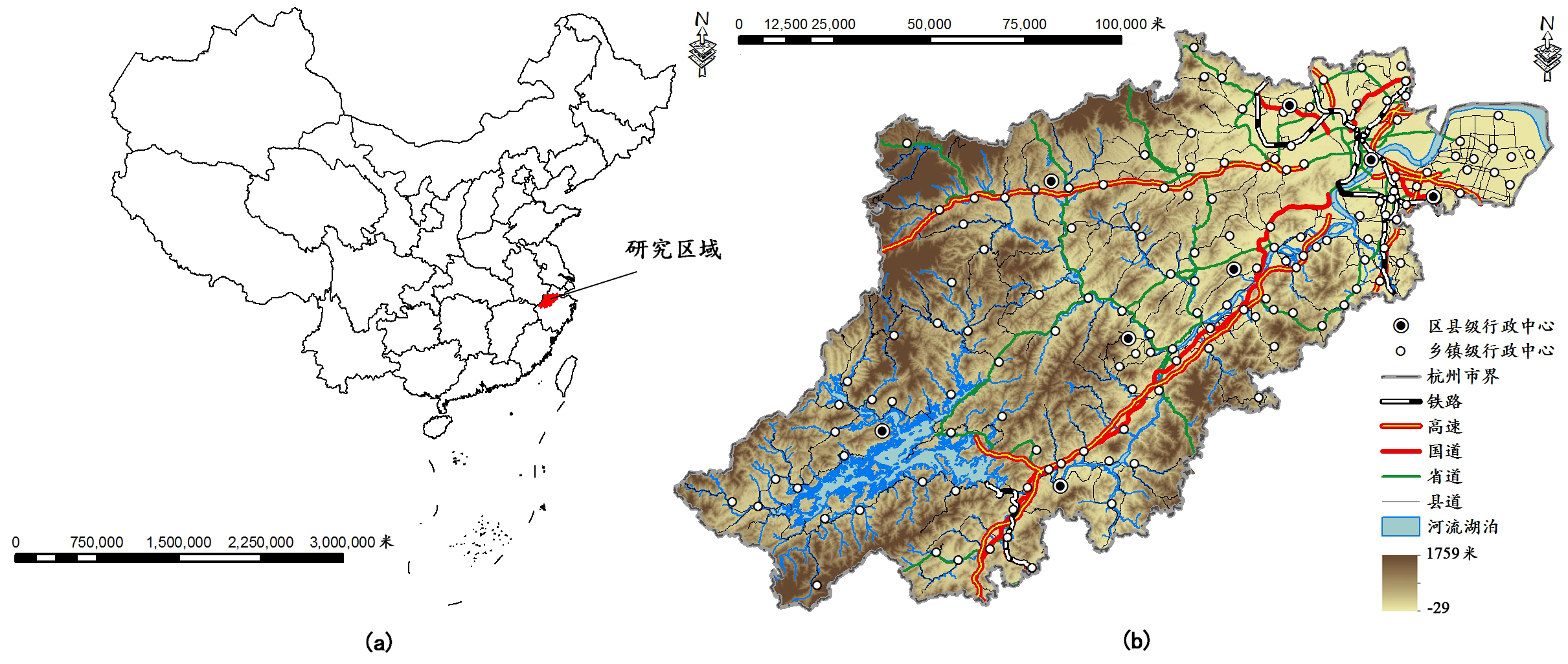
Tea Plantation Expansion in Southeast of China: Process, Driving Forces and Ecological Effect
Internship
Internship Position:
Time:
10/2020 - 12/2020
Company:
Team:
Core AI Team
Mentor:
Dr. Hongxu Ma (Tech Lead)
Location:
Mountain View, CA, USA
Internship Position:
Time:
06/22/2020 - 09/11/2020
Company:
Team:
Core AI Team
Mentor:
Dr. Hongxu Ma (Tech Lead)
Location:
Mountain View, CA, USA
Topic:
Time Series Forecasting, Causal Discovery/Inference
Internship Position:
Cartographic Engineer Intern (Machine Learning)
Time:
06/17/2019 - 09/06/2019
Company:
Team:
Apple Map Cartographic Team
Mentor:
Location:
Cupertino, CA, USA
Topic:
Graph Neural Network, Map Generalization
Internship Position:
Machine Learning & NLP Research Intern
Time:
06/18/2018 - 09/21/2018
Company:
Mentor:
Location:
Palo Alto, CA, USA
Topic:
Deep Reinforcement Learning, Sequence Model, Q&A, IR, NLP
Internship Position:
Software Development Internship
Time:
06/27/2017 - 09/15/2017
Mentor:
Sathya Prasad
Location:
Redlands, CA, USA
Used Technology:
Elasticsearch, Mechine Learning/Natural Language Processing (Artificial Neural Network, Named Entity Recognition), QML
Publication
Thesis:
Master Thesis: Gengchen Mai. ADCN: An Anisotropic Density-Based Clustering Algorithm for Discovering Spatial Point Patterns with Noise. In UC Santa Barbara Electronic Theses and Dissertations, escholarship.
Book chapters:
3.Song Gao, Mingxiao Li, Jinmeng Rao, Gengchen Mai, Timothy Prestby, Joseph Marks, Yingjie Hu. Automatic Urban Road Map Generation from Massive GPS Trajectories of Taxis. In Martin Werner, Yao-Yi Chiang et al.(Eds): Handbook of Big Geospatial Data, Springer. [code]
2.Bo Yan, Gengchen Mai, Yingjie Hu, Krzysztof Janowicz. Harnessing Heterogeneous Big Geospatial Data. In Martin Werner, Yao-Yi Chiang et al.(Eds): Handbook of Big Geospatial Data, Springer.
1.Song Gao, Gengchen Mai. Mobile GIS and Location-Based Services. In Bo Huang, Thomas J. Cova, and Ming-Hsiang Tsou et al.(Eds): Comprehensive Geographic Information Systems, Elsevier. Oxford, UK..
Peer-reviewed Journal Articles:
10.Gengchen Mai, Krzysztof Janowicz, Ling Cai, Rui Zhu, Blake Regalia, Bo Yan, Meilin Shi, Ni Lao. SE-KGE: A Location-Aware Knowledge Graph Embedding Model for Geographic Question Answering and Spatial Semantic Lifting. Transactions in GIS. DOI:10.1111/tgis.12629 [arxiv paper] [code] [video] [slides]
9.Ling Cai, Krzysztof Janowicz, Gengchen Mai, Bo Yan, Rui Zhu. Traffic Transformer: Capturing the Continuity and Periodicity of Time Series for Traffic Forecasting. Transactions in GIS. DOI:10.1111/tgis.12644
8.Gengchen Mai, Krzysztof Janowicz, Bo Yan, Simon Scheider. Deeply Integrating Linked Data with Geographic Information Systems. Transactions in GIS, 23(2019), 579-600. DOI:10.1111/tgis.12538 [code] [demo video]
7.Bo Yan, Krzysztof Janowicz, Gengchen Mai, Rui Zhu. A Spatially-Explicit Reinforcement Learning Model for Geographic Knowledge Graph Summarization. Transactions in GIS, 23(2019), 620-640. DOI:10.1111/tgis.12547
6.Rui Zhu, Krzysztof Janowicz, Gengchen Mai. Making Direction a First-Class Citizen of Tobler's First Law of Geography. Transactions in GIS, 23(2019), 398-416. DOI:10.1111/tgis.12550
5.Krzysztof Janowicz, Pascal Hitzler, Blake Regalia, Gengchen Mai, Stephanie Delbecque, Maarten Frohlich, Patrick Martinent, Trevor Lazarus. On the Prospects of Blockchain and Distributed Ledger Technologies for Open Science and Academic Publishing [Editorial]. Semantic Web Journal, in press.
4.Gengchen Mai, Krzysztof Janowicz, Yingjie Hu, Song Gao. ADCN: An Anisotropic Density-Based Clustering Algorithm for Discovering Spatial Point Patterns with Noise. Transactions in GIS, 22(2018), 348-369. DOI:10.1111/tgis.12313 [code] * Top 10% Most Downloaded Papers in TGIS (01/2018-12/2019)
3.Shiliang Su, Yaping Wang, Fanghan Luo, Gengchen Mai, Jian Pu. Peri-urban vegetated landscape pattern changes in relation to socioeconomic development. Ecological Indicators 46 (2014) 477–486.
2.Shiliang Su, Yi’na Hu, Fanghan Luo, Gengchen Mai, Yaping Wang. Farmland fragmentation due to anthropogenic activity in rapidly developing region. Agricultural Systems 131 (2014) 87–93.
1.Rui Xiao, Shiliang Su, Gengchen Mai, Zhonghao Zhang, Chenxue Yang. Quantifying determinants of cash crop expansion and their relative effects using logistic regression modeling and variance partitioning. International Journal of Applied Earth Observation and Geoinformation 34 (2015) 258–263.
Peer-reviewed Conference Paper:
19.Gengchen Mai, Krzysztof Janowicz, Sathya Prasad, Meilin Shi, Ling Cai, Rui Zhu, Blake Regalia, Ni Lao. Semantically-Enriched Search Engine for Geoportals: A Case Study with ArcGIS Online, In: Proceedings of AGILE 2020, , Jun. 16 - 19, 2020, Chania, Crete, Greece. [arxiv paper] [code]
18.Gengchen Mai, Krzysztof Janowicz, Bo Yan, Rui Zhu, Ling Cai, Ni Lao. Multi-Scale Representation Learning for Spatial Feature Distributions using Grid Cells, In: Proceedings of ICLR 2020, Apr. 26 - 30, 2020, Addis Ababa, ETHIOPIA . [OpenReview paper] [arxiv paper] [code] [video] [slides] * Spotlight Paper (Acceptance Rate 6%, 156 out of 2594 submissions)
17.Gengchen Mai, Krzysztof Janowicz, Bo Yan, Rui Zhu, Ling Cai, Ni Lao. Contextual Graph Attention for Answering Logical Queries over Incomplete Knowledge Graphs, In: Proceedings of K-CAP 2019, Nov. 19 - 21, 2019, Marina del Rey, CA, USA. [arxiv]
16.Ling Cai, Bo Yan, Gengchen Mai, Krzysztof Janowicz, Rui Zhu. TransGCN: A Translation-Based Graph Convolutional Network Model for Link Prediction, In: Proceedings of K-CAP 2019, Nov. 19 - 21, 2019, Marina del Rey, CA, USA. [arxiv] * 1st Best Full Paper Award
15.Gengchen Mai, Bo Yan, Krzysztof Janowicz, Rui Zhu. Relaxing Unanswerable Geographic Questions Using A Spatially Explicit Knowledge Graph Embedding Model, In: Proceedings of AGILE 2019, June 17 - 20, 2019, Limassol, Cyprus. * 1st Best Full Paper Award
14.Gengchen Mai, Krzysztof Janowicz, Cheng He, Sumang Liu and Ni Lao. POIReviewQA: A Semantically Enriched POI Retrieval and Question Answering Dataset [Short Paper], In: Proceedings of GIR'18 Workshop co-located with ACM SIGSPATIAL 2018, Nov. 6 - 9, 2018, Seattle, Washington, USA. [arxiv]
13.Gengchen Mai, Krzysztof Janowicz, Bo Yan. Support and Centrality: Learning Weights for Translation-based Knowledge Graph Embedding Models, In: Proceedings of EKAW 2018, Nov. 12 - 16, 2018, Nancy, France.
12.Krzysztof Janowicz, Bo Yan, Blake Regalia, Rui Zhu, Gengchen Mai. Debiasing Knowledge Graphs: Why Female Presidents are not like Female Popes [Vision Paper], In: Proceedings of ISWC 2018, Oct. 8 - 12, 2018, Monterey, CA, USA.
11.Gengchen Mai, Krzysztof Janowicz, Bo Yan. Combining Text Embedding and Knowledge Graph Embedding Techniques for Academic Search Engines, In: Proceedings of SemDeep-4 Workshop co-located with ISWC 2018, Oct. 8 - 12, 2018, Monterey, CA, USA.
10.Gengchen Mai, Krzysztof Janowicz, Yingjie Hu, Song Gao, Rui Zhu, Bo Yan, Grant McKenzie, Anagha Uppal, and Blake Regalia. Collections of Points of Interest: How to Name Them and Why it Matters [Short Paper], In: Proceedings of Spatial big data and machine learning in GIScience Workshop at GIScience 2018, August 28 - 31, 2018, Melbourne, Australia.
9.Bo Yan, Krzysztof Janowicz, Gengchen Mai, Rui Zhu. xNet+SC: Classifying Places Based on Images by Incorporating Spatial Contexts, In: Proceedings of the 10th International Conference on Geographic Information Science (GIScience 2018), August 28 - 31, 2018, Melbourne, Australia.
8.Gengchen Mai, Krzysztof Janowicz, Sathya Prasad, Bo Yan. Visualizing The Semantic Similarity of Geographic Features [Short Paper], In: Proceedings of 21st Conference on Geo-information science (AGILE 2018), June 12 - 15, 2018, Lund, Sweden.
7.Blake Regalia, Krzysztof Janowicz, Gengchen Mai, Dalia Varanka, E Lynn Usery. GNIS-LD: Serving and Visualizing the Geographic Names Information System Gazetteer As Linked Data, In: Proceedings of ESWC 2018, June 3 - 7, 2018, Heraklion, Crete, Greece.
6.Bo Yan, Krzysztof Janowicz, Gengchen Mai, Song Gao. From ITDL to Place2Vec -- Reasoning About Place Type Similarity and Relatedness by Learning Embeddings From Augmented Spatial Contexts, In: Proceedings of the 25th International Conference on Advances in Ge-ographic Information Systems (ACM SIGSPATIAL 2017), November 7 - 10, 2017, Redondo Beach, California, USA.
5.Blake Regalia, Krzysztof Janowicz, Gengchen Mai. Phuzzy.link: A SPARQL-Powered Client-Sided Extensible Semantic Web Browser, In: Proceedings of 3rd International Workshop on Visualization and Interaction for Ontologies and Linked Data (VOILA2017) co-located with ISWC 2017, October 22, 2017, Vienna, Austria.
4.Gengchen Mai, Krzysztof Janowicz, Yingjie Hu, Song Gao. ADCN: An Anisotropic Density-Based Clustering Algorithm [Short paper], In: Proceedings of the 24th International Conference on Advances in Geographic Information Systems (ACM SIGSPATIAL 2016), October 31 - November 3, 2016, San Francisco Bay Area, California, USA.
3.Gengchen Mai, Krzysztof Janowicz, Yingjie Hu, Grant McKenzie. A Linked Data Driven Visual Interface for the Multi-Perspective Exploration of Data Across Repositories, In: Proceedings of 2nd International Workshop on Visualization and Interaction for Ontologies and Linked Data (VOILA2016) co-located with ISWC 2016, October 17 or 18, 2016, Kobe, Japan.
2.Song Gao, Rui Zhu, Gengchen Mai. Identifying Local Spatiotemporal Autocorrelation Patterns of Taxi Pick-ups and Drop-offs [Short paper], In: Proceedings of the 9th International Conference on Geographic Information Science (GIScience 2016), September 27 - 30, 2016, Montreal, Canada.
1.Krzysztof Janowicz, Yingjie Hu, Grant McKenzie, Song Gao, Blake Regalia, Gengchen Mai, Rui Zhu, Benjamin Adams, Kerry Taylor. Moon Landing or Safari? A Study of Systematic Errors and their Causes in Geographic Linked Data, In: Proceedings of the 9th International Conference on Geographic Information Science (GIScience 2016), September 27 - 30, 2016, Montreal, Canada.
Other Publication:
1.Gengchen Mai. Spatially Explicit Machine Learning Model, In: Spatial Data Science Symposium 2019, Dec. 9 - 11, 2019, Santa Barbara, CA, USA.
Patent:
1. US Patent 16240539: Gengchen Mai, Cheng He, Sumang Liu, Ni Lao. System and method for natural language processing (nlp) based searching and question answering.
Conference Oral/Poster Presentation:
23. Online Oral presentation (2020): Space2Vec: Multi-Scale Representation Learning for Spatial Feature Distributions using Grid Cells, In Google AI Tech Talk 2020, August 12, 2020, Mountain View, CA, USA.
22. Online Video presentation (2020): SE‐KGE : A location‐aware Knowledge Graph Embedding model for Geographic Question Answering and Spatial Semantic Lifting, In Esri UC 2020, July 13 - 16, 2020, San Diego, CA, USA. [video]
21. Online Video presentation (2020): Multi-Scale Representation Learning for Spatial Feature Distributions using Grid Cells, In ICLR 2020, Apr. 26 - 30, 2020, Addis Ababa, ETHIOPIA. [video]
20. Oral presentation (2020): Knowledge Graphs and Spatiotemporal Data, In NSF OKN VoCamp 2020, Jan. 27 - 28, 2019, Santa Barbara, CA, USA.
19. Oral presentation (2019): Knowledge Graphs and Spatiotemporal Data, In Spatial Data Science Symposium 2019, Dec. 9 - 11, 2019, Santa Barbara, CA, USA.
18. Oral presentation (2019): Contextual Graph Attention for Answering Logical Queries over Incomplete Knowledge Graphs, In K-CAP 2019, Nov. 19 - 21, 2019, Marina del Rey, CA, USA.
17. Oral presentation (2019): A Spatially Explicit Machine Learning Model for Map Generalization, In Apple Map Leadership Presentation, August 15, 2019, Sunnyvale, CA, USA.
16. Poster presentation (2019): A Spatially Explicit Machine Learning Model for Map Generalization, In Apple Intern Machine Learning Symposium 2019, August 1, 2019, Cupertino, CA, USA.
15. Oral presentation (2019): Deeply Integrating Linked Data with Geographic Information Systems, In Esri UC 2019, July 8 - 13, 2019, San Diego, CA, USA.
14. Oral presentation (2019): Relaxing Unanswerable Geographic Questions Using A Spatially Explicit Knowledge Graph Embedding Model, In Spatial Discovery III, May 1 - May 3, 2019, Santa Barbara, CA, USA.
13. Oral presentation (2019): Relaxing Unanswerable Geographic Questions Using A Spatially Explicit Knowledge Graph Embedding Model, In Annual Meeting of AAG 2019: GeoAI and Deep Learning Symposium: Geo-Text Data and Location-based Social Media, April 3 - April 7, 2019, Washington DC, USA.
12. Oral presentation (2018): Support and Centrality: Learning Weights for Translation-based Knowledge Graph Embedding Models, In EKAW 2018, Nov. 12 - 16, 2018, Nancy, France.
11. Oral presentation (2018): POIReviewQA: A Semantically Enriched POI Retrieval and Question Answering Dataset, In GIR'18 Workshop co-located with ACM SIGSPATIAL 2018, Nov. 6 - 9, 2018, Seattle, Washington, USA.
10. Oral presentation (2018): Combining Text Embedding and Knowledge Graph Embedding Techniques for Academic Search Engines, In SemDeep-4 Workshop co-located with ISWC 2018, Oct. 8 - 12, 2018, Monterey, CA, USA.
9. Oral presentation (2018): xNet+SC: Classifying Places Based on Images by Incorporating Spatial Contexts, In GIScience 2018, Aug 27 - 31, 2018, Melbourne, Australia.
8. Oral presentation (2018): Collections of Points of Interest: How to Name Them and Why it Matters, In Spatial big data and machine learning in GIScience Workshop at GIScience 2018, Aug 27 - 31, 2018, Melbourne, Australia.
7. Oral presentation (2018): Visualizing The Semantic Similarity of Geographic Features, In AGILE 2018, June 12 - 15, 2018, Lund, Sweden.
6. Oral presentation (2018): Visualizing The Semantic Similarity of Geographic Features, In Annual Meeting of AAG 2018: Artificial Intelligence and Deep Learning Symposium: Geospatial Semantics and Geo-Text Data Analytics II, April 10 - April 14, 2018, New Orleans, Louisiana, USA.
5. Oral presentation (2017): A Semantically Enabled Geographic Information Retrieval Framework by using Representation Learning: A Simple Case Study of DBpedia, In GIS Day@UCSB Geography, November 17, 2017, Santa Barbara, California, USA.
4. Oral presentation (2017): ADCN: An Anisotropic Density-Based Clustering Algorithm for Discovering Spatial Point Patterns with Noise, In Annual Meeting of AAG 2017: Spatiotemporal Symposium -- Big Spatiotemporal Data Discovery and Mining Session, April 5- April 9, 2017, San Francisco, California, USA.
3. Poster presentation (2016): ADCN: An Anisotropic Density-Based Clustering Algorithm, In 24th International Conference on Advances in Geographic Information Systems (ACM SIGSPATIAL 2016) , October 31 - November 3, 2016, San Francisco Bay Area, California, USA.
2. Poster presentation (2016): A Linked Data Driven Visual Interface for the Multi-Perspective Exploration of Data Across Repositories, In 12th Reasoning Web Summer School (RW 2016) co-located with 10th International Conference on Web Reasoning and Rule Systems (RR 2016) , September 5 - 9, 2016, Aberdeen, Scotland, UK.
1. Oral presentation (2016): Tea Plantation Expansion in Hangzhou, China: Process, Related factors & Ecological Effect, In 2016 Annual Meeting of AAG: The Quest to Map Plant Species Session, March 28- April 1, 2016, San Francisco, California, USA.
Research Experience & Project
Spatially-Explicit Models, Methods, And Services For Open Knowledge Networks
Graduate Student Researcher at STKO Lab, UCSB
2019/09 - 2020/06
POI Retrieval and Question Answering
Machine Learning & NLP Research Intern at Saymosaic Inc.
2018/06 - 2018/09
Many services that perform information retrieval for Points of Interest (POI) utilize a Lucene-based setup with spatial filtering. While this type of system is easy to implement it does not make use of semantics but relies on direct word matches between a query and reviews leading to a loss in both precision and recall. To study the challenging task of semantically enriching POIs from unstructured data in order to support open-domain search and question answering (QA), we introduce a new dataset POIReviewQA. It consists of 20k questions (e.g.“is this restaurant dog friendly?”) for 1022 Yelp business types. For each question we sampled 10 reviews, and annotated each sentence in the reviews whether it answers the question and what the corresponding answer is. To test a system’s ability to understand the text we adopt an information retrieval evaluation by ranking all the review sentences for a question based on the likelihood that they answer this question. We build a Lucene-based baseline model, which achieves 77.0% AUC and 48.8% MAP. A sentence embedding-based model achieves 79.2% AUC and 41.8% MAP, indicating that the dataset presents a challenging problem for future research by the GIR community. The result technology can help exploit the thematic content of web documents and social media for characterisation of locations.
Topic:
Question Answering, Information Retrieval, Deep Reinforcement Learning
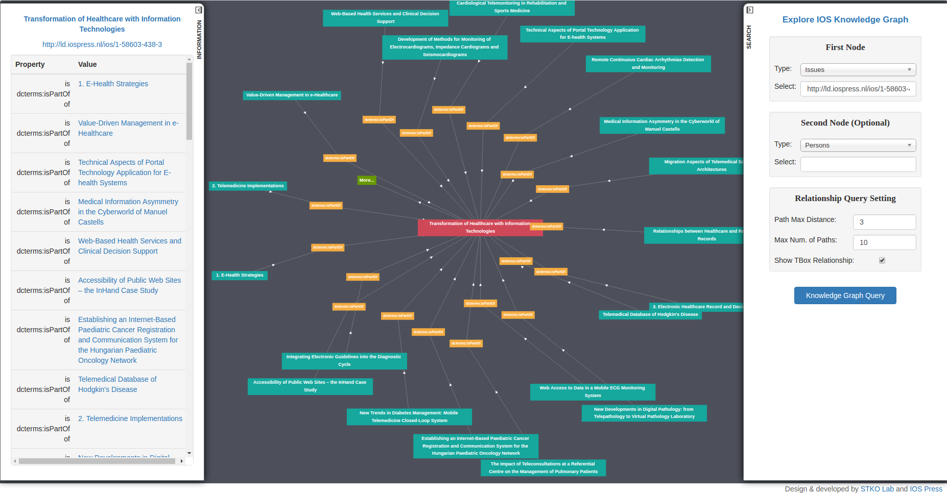
IOS LD Connect Academic Search Engine And Reviewer Suggestion System
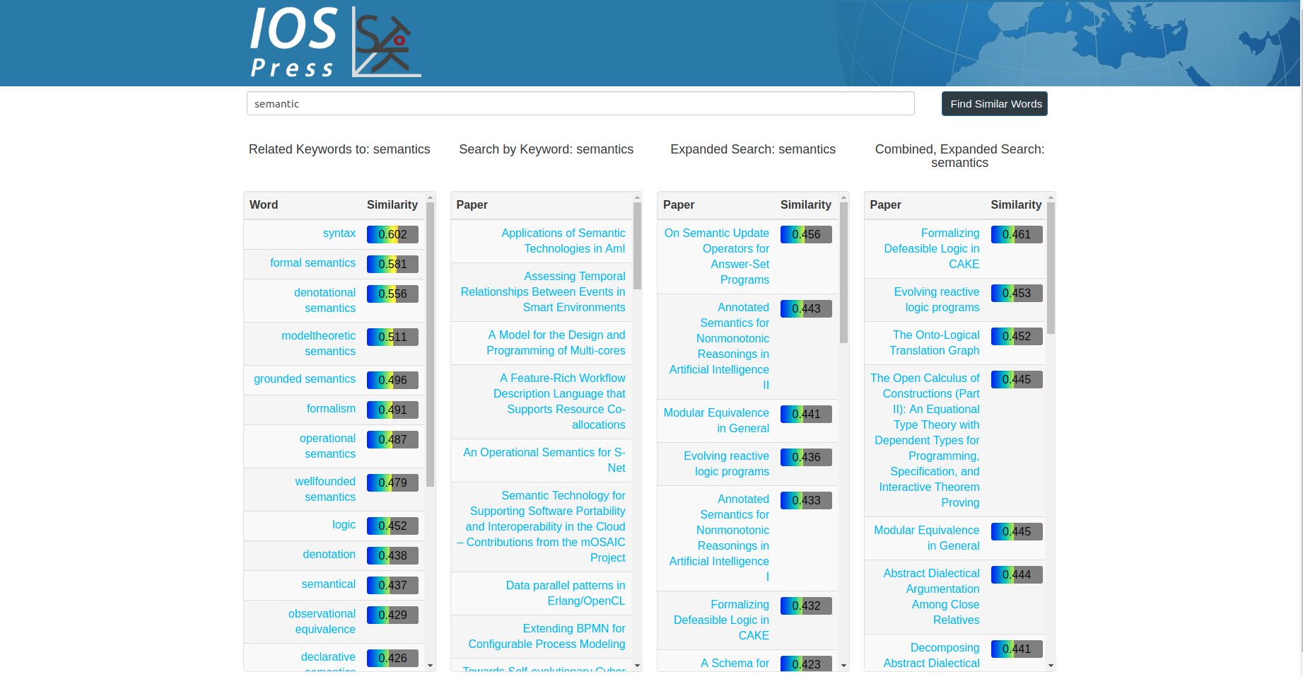
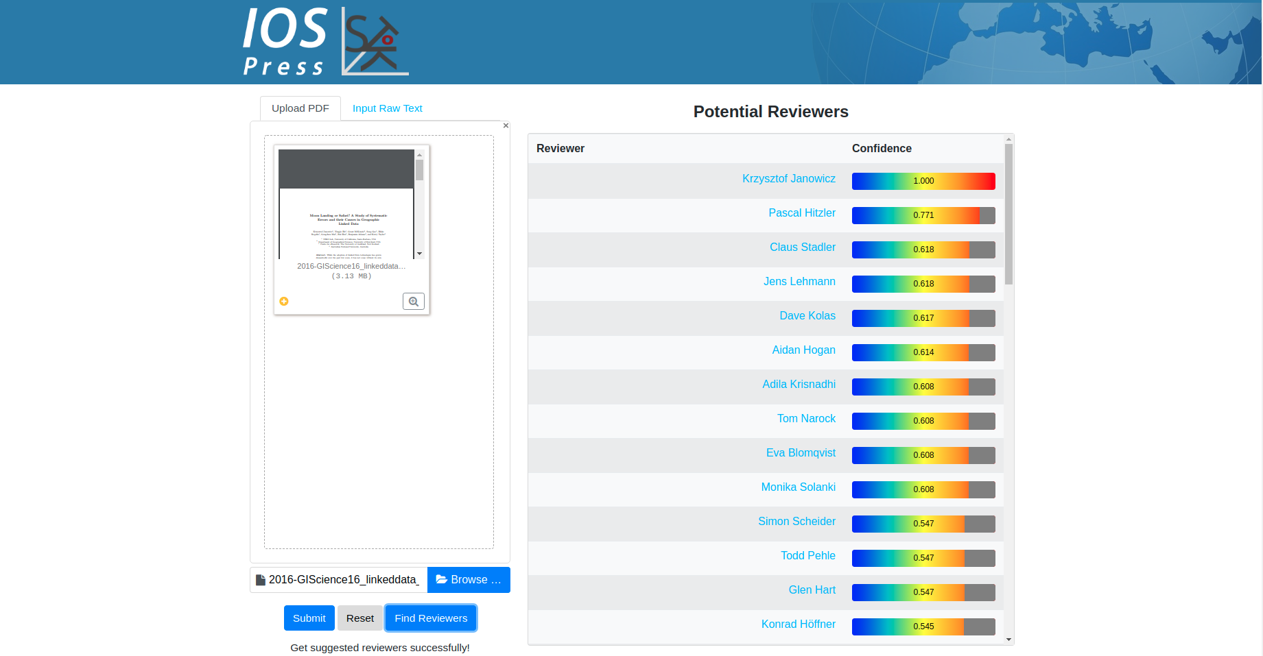
Graduate Student Researcher in STKO Lab, Department of Geography, UCSB
2017/03 - Present
In this work, An academic search engine has been developed on top of IOS LD Connect Knowledge Graph. Document Embedding and Knowledge Graph Embedding have been utilized to facilitate the searching for papers, authors, and reviewers. Note that this search engine has been adopted as the official academic search engine for IOS Press.
ESRI Linked Data Connecter
Graduate Student Researcher in STKO Lab, Department of Geography, UCSB
2016/10 - Present
In this work, we conceptualized and prototypically implemented a Linked Data connector framework as a set of toolboxes for Esri’s ArcGIS. We discussed from within a GIS, how to connect to Linked Data endpoints, how to use ontologies to probe data and derive appropriate GIS representations on-the-fly, how to make use of reasoning, how to derive data that is ready for spatial analysis out of RDF triples, and, most importantly, how to utilize the link structure of Linked Data to enable analysis.
GitHub Code Repository:
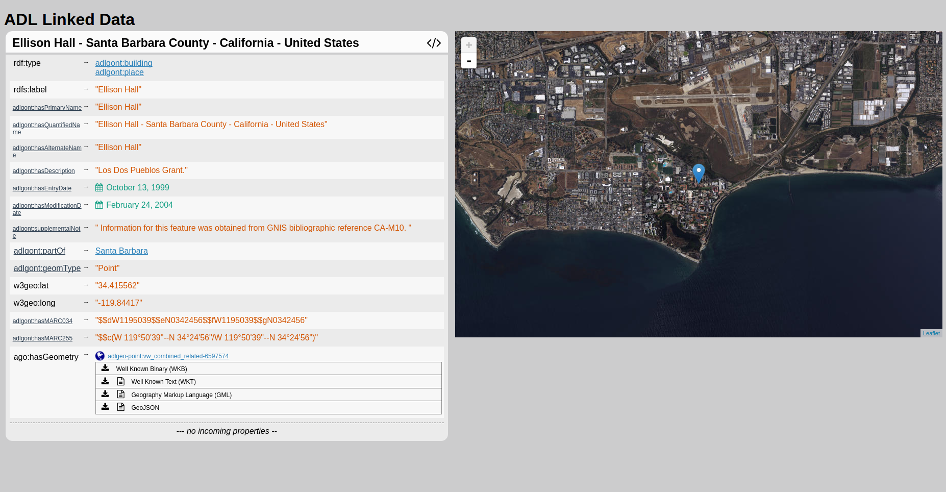
Alexandria Digital Library (ADL) Gazetteer

Graduate Student Researcher in STKO Lab, Department of Geography, UCSB
2016/08 - Present
Funded by IOS Press
Alexandria Digital Library (ADL) is UC Santa Barbara Library's home for collections of digital research materials. This project aims at leveraging Semantic Web technologies, especially GeoSPARQL, to facilitate the spatial/no-spatial query of ADL Gazetteer and dynamically visualize the results. Right now, the ADL Gazetteer data has been held and managed in a modified version of Apache Marmotta triple store in which GeoSPARQL is enabled. Thanks to all the help from STKO lab members, two different interfaces have been established to facilitate users to interactively explore the geographic data in ADL Gazetteer which are list bellow:
ADL Map Interface:
This is a map interface to help users do spatial/no-spatial queries on ADL Gazetteer, like finding all the entities in "administrative region" class in current map layout whose label contains "paris". GeoSPARQL is used to do spatial queries. Acknowledge to Grant McKenzie and Bo Yan.
ADL Linked Data Visualizer:
This is a dereferencing user interface for all the entities and entity types in ADL Gazetteer. For example, UC Santa Barbara can be dereferenced by THIS IRI. Acknowledge to Blake Regalia. See more information for our Phuzzy.link paper
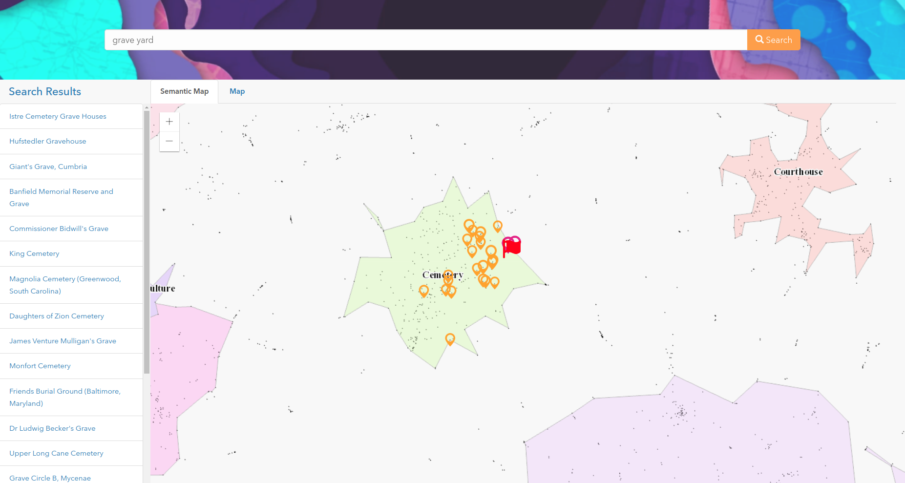
.Esri Hackathon Project: Visualizing The Semantic Similarity of Geographic Features
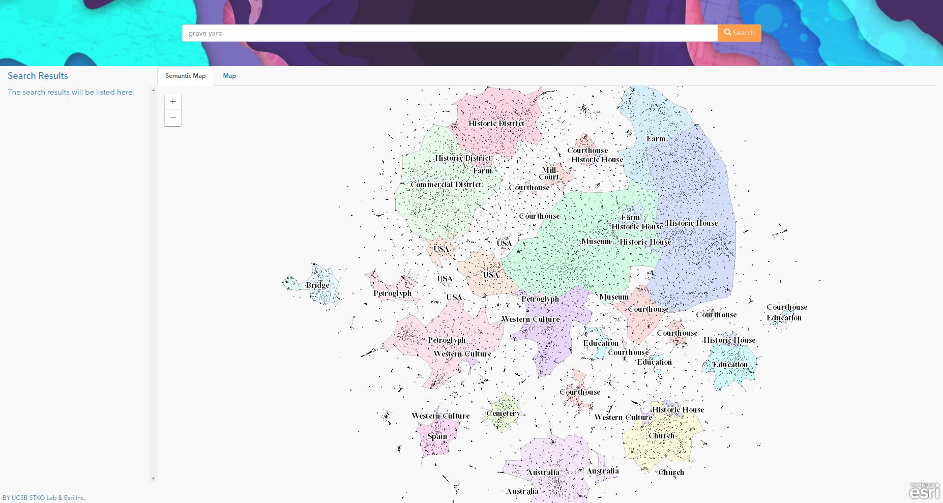
Esri Inc., Redlands, CA, USA
2017/07/16 - 2017/07/18
In this work, a semantically enriched geospatial data visualization and searching framework and evaluated it using a subset of places from DBpedia. The resulting map, as a representation of the semantic distribution of these geographic features, is produced by using multiple techniques including paragraph vector and clustering. Next, an information retrieval (IR) model is developed based on the vector embedding of each geographic feature. The results are visualized using the semantic similarity-based map as well as a regular map. We believe such visualization can help users to understand latent relationships between geographic features that may otherwise seem unrelated.
IOS Press RelFinder
Graduate Student Researcher in STKO Lab, Department of Geography, UCSB
2016/10 - Present
In this work, we developed an Linked Data Visualization Interface for IOS Press Linked Dataset. This interface can visualize the Linked Data Cloud as a graph and users can further explore the graph content using right click menu. The Left sidebar will display the information of the current entity. The irght sidebar helps users do "Relationship Finder" style search.
URL: http://stko-testing.geog.ucsb.edu/gengchen/IOSRelFinder/
An Anisotropic Density-Based Clustering Algorithm (ADCN)
Graduate Student Researcher in STKO Lab, Department of Geography, UCSB
2015/09 - 2017/06
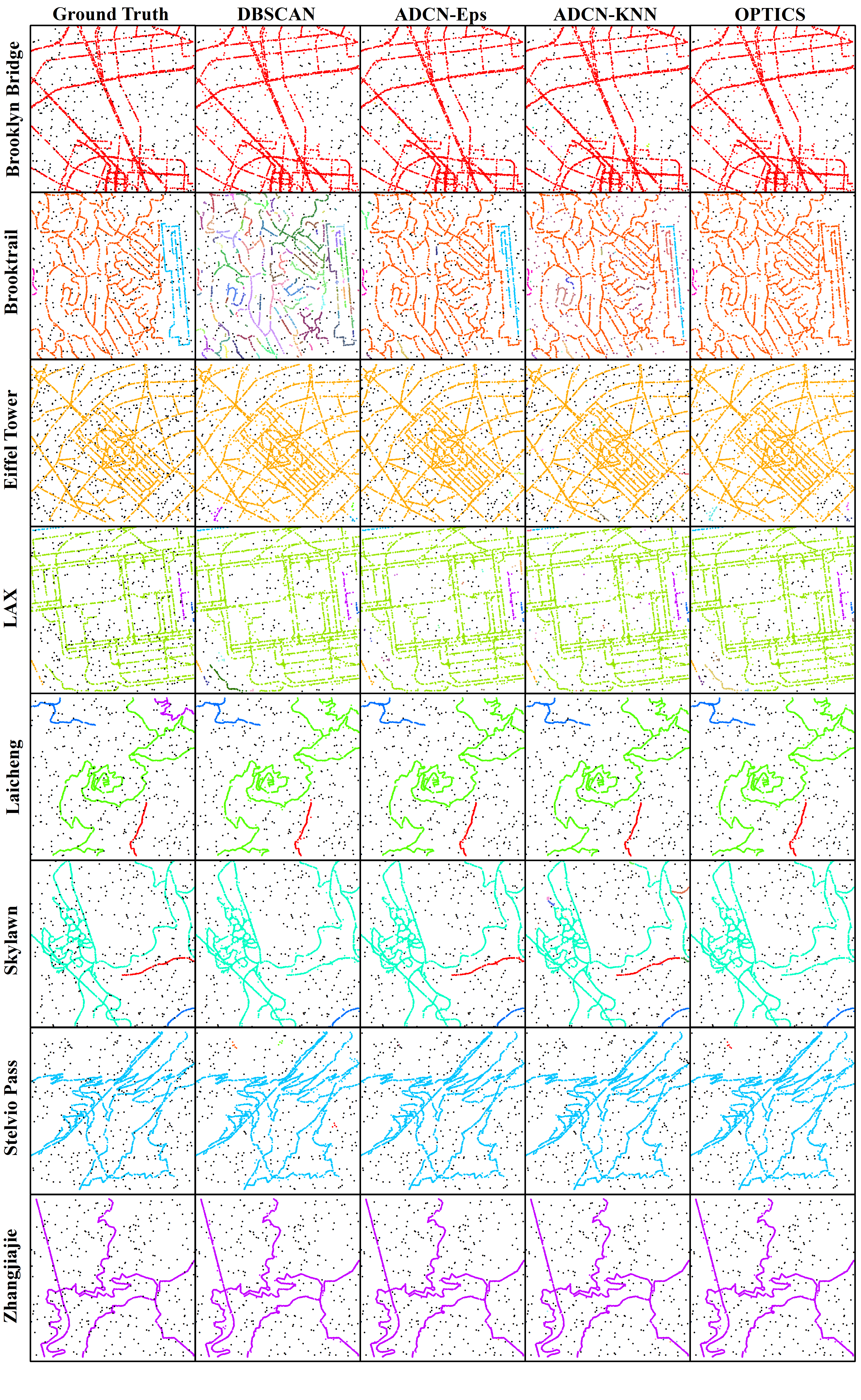
Density-based clustering algorithms such as DBSCAN have been widely used for spatial knowledge discovery as they offer several key advantages compared to other clustering algorithms. They can discover clusters with arbitrary shapes, are robust to noise and do not require prior knowledge (or estimation) of the number of clusters. The idea of using a scan circle centered at each point with a search radius Eps to find at least MinPts points as a criterion for deriving local density is easily understandable and sufficient for exploring isotropic spatial point patterns. However, there are many cases that cannot be adequately captured this way, particularly if they involve linear features or shapes with a continuously changing density such as a spiral. In such cases, DBSCAN tends to either create an increasing number of small clusters or add noise points into large clusters. Therefore, in this paper, we propose a novel anisotropic density-based clustering algorithm (ADCN). To motivate our work, we introduce synthetic and real-world cases that cannot be sufficiently handled by DBSCAN (and OPTICS). We then present our clustering algorithm and test it with a wide range of cases. We demonstrate that our algorithm can perform as equally well as DBSCAN in cases that do not explicitly benefit from an anisotropic perspective and that it outperforms DBSCAN in cases that do. We show that our approach has the same time complexity as DBSCAN and OPTICS, namely O(n log n) when using a spatial index and O(n 2 ) otherwise. We provide an implementation and test the runtime over multiple cases. Finally, we apply DBSCAN, OPTICS, and our ADCN to the extraction of urban Areas of interest (AOI) from geotagged photos in six cities. Visual comparison shows that, comparing to DBSCAN and OPTICS, ADCN is inclined to extract AOI with linear shapes which follow the underline road network. ADCN also turn out to connect areas when the spatial distribution of them shows similar direction.
Data & Platform:
GitHub JS Code Repository:
GitHub Python Code Repository:
GeoLink
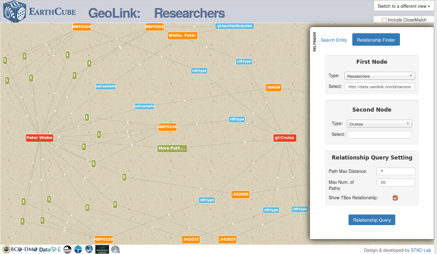
Graduate Student Researcher in National Center for Ecological Analysis and Synthesis (NCEAS), UCSB
2016/01 - 2016/04
Funded by NSF EarthCube program
GeoLink is a building block project of EarthCube project. It aims at building up a oceanography data integration framwork for seven data repositories and a collections of Ontology Design Patterns. My contribution in this project is creating a graph visualizer to query the paths between two entities. This graph visualizer help the user to discover the data by follow-your-nose search across different data repositories.
Undergraduate Research & Thesis
Thesis Topic:
Tea Plantation Expansion in Southeast of China: Process, Driving Forces and Ecological Effect
The coupling mechanism of farmland’s service function and landscape fragmentation
2014/01 - 2015/07
Funded by the Fundamental Research Funds for the Central Universities (No. 2042014kf0048)
The construction of generalization classifier by using phenological index to extract the farmland information
2014/01 - 2015/12
Funded by Open Research Fund Program of Key Laboratory of Digital Mapping and Land Information Application Engineering, National Administration of Surveying, Mapping and Geoinformation (No. GCWD201404)
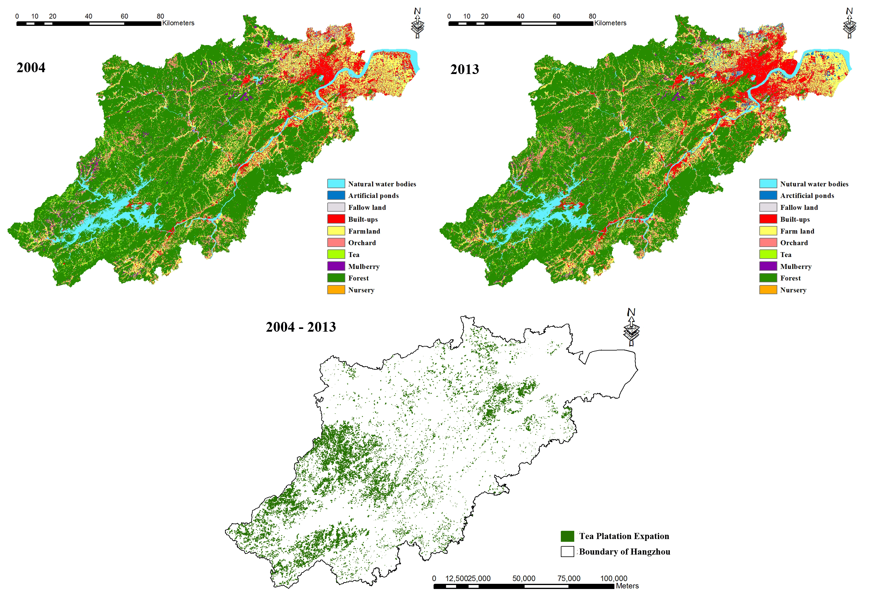
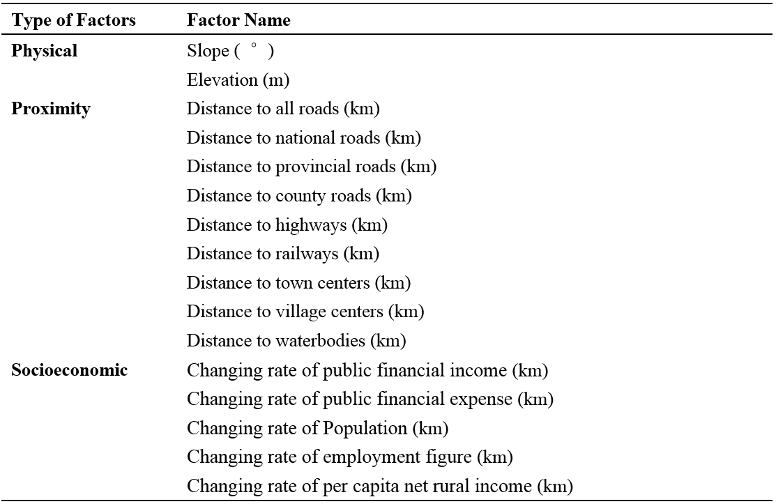
Recently, tea plantation expansion has become a typical land use change in the subtropical zone of China. My experiment integrated remote sensing, spatial analysis deriving from geographic information system, landscape metric analysis and spatial regression, to quantify the socioeconomic indicators of tea plantation expansion and its effects on landscape pattern, with a case of Hangzhou, China, from 2004 to 2013. Main results showed that: (1) Hangzhou has undergone great tea plantation expansion, about 54975.9 ha, from 2004 to 2013. (2) Tea plantation expansion is highly related to some physical, social, and economical factors: slope, elevation, distance to water bodies, distance to roads, distance to socioeconomic centers, public financial revenue and per capita average income of farmers. (4) Tea plantation expansion would make the landscape become fragmentized, complex and irregular. Our study contributed to understanding the socioeconomic indicators of tea plantation expansion and its effects on landscape pattern in subtropical China.
Sina-Blog Check-in Project
Project leader: The Extraction of Point of Interest Based on Multi-source Check-in Data
2013/05 - 2015/06
Funded by Planning Project of Innovation and Entrepreneurship Training of National Undergraduate of Wuhan University (No.1310486034)
As a project leader of this undergraduate training project, I developed a C# Application to get check-in data form Sina-blog. And then we evaluated the effect of the construction of Wuhan Subway Line 2 on the spatial distribution of Sina-Blog Check-in data.
URL: Flow Analysis and Research on Subway Based on "Sina micro-blog" Registration data
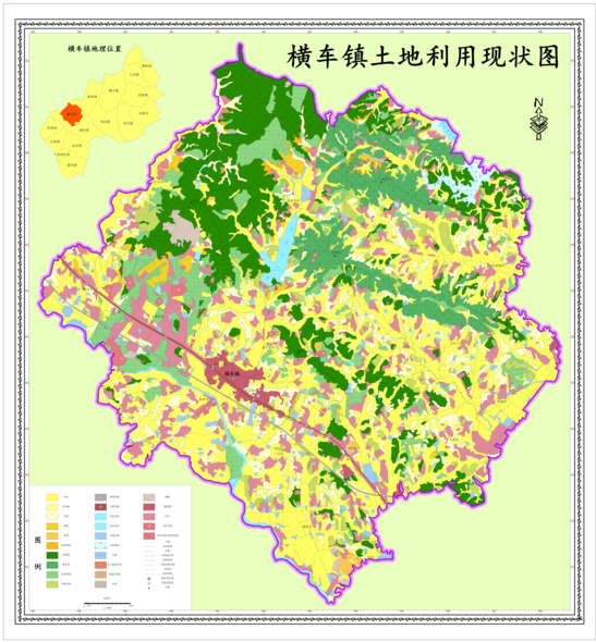
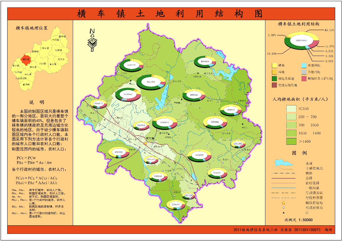
GIS & Cartography Course Project
A One month GIS & Cartography Course project
2014/12 - 2015/01
I made two maps of Hengche County by ArcGIS Deasktop. Left one shows the current land use map of Hengche County. The right one shows the Current land use stucture of Hengche County.
Research Grant
Title:
A Hybrid Spatially-Explicit Machine Learning Model for Species Spatio-temporal Distribution Modeling and Biodiversity Hotspot Prediction
Role:
Principle Investigator
Time:
2020/06/15 - 2020/09/25
Member:
Gengchen Mai (PI)
Title:
Deep species spatio-temporal distribution modeling for biodiversity hotspot prediction
Grant:
Role:
Principle Investigator
Time:
2019/11 - 2020/11
Member:
Gengchen Mai (PI), Krzysztof Janowicz, Ni Lao, WenyunZuo, Ling Cai.
Award
2020/06/15 - 2020/09/27
2020/06/15 - 2020/09/27
2020/04/26
2019/11/19 - 2019/11/21
The Jack & Laura Dangermond Travel Scholarship for K-CAP 2019
2019/11/21
The 1st Place Best Full Paper Award at K-CAP 2019 for "TransGCN: A Translation-Based Graph Convolutional Network Model for Link Prediction"
2019/07/08 - 2019/07/13
The Jack & Laura Dangermond Travel Scholarship for 2019 Esri UC
2019/06/20
The 1st Place Best Full Paper Award at AGILE 2019 for "Relaxing Unanswerable Geographic Questions Using A Spatially Explicit Knowledge Graph Embedding Model"
2019/04/02 - 2019/04/07
The Jack & Laura Dangermond Travel Scholarship for 2019 AAG Annual Meeting
2018/11/12 - 2018/11/16
The Jack & Laura Dangermond Travel Scholarship for EKAW 2018
2018/11/06 - 2018/11/09
The Jack & Laura Dangermond Travel Scholarship for ACM SIGSPATIAL 2018
2018/10/08 - 2018/10/12
NSF Student Travel Awards for ISWC 2018
2018/08/27 - 2018/08/31
ESRI GIScience 2018 Student Travel Awards
2018/08/27 - 2018/08/31
The Jack & Laura Dangermond Travel Scholarship for GIScience 2018
2018/06/12 - 2018/06/15
The Jack & Laura Dangermond Travel Scholarship for AGILE 2018
2018/04/10 - 2018/04/14
The Jack & Laura Dangermond Travel Scholarship for 2018 AAG Annual Meeting
2018/03/01 - 2018/03/02
NSF Student Fellowship for U.S. Semantic Technologies Symposium 2018 (US2TS 2018)
2017/11/07 - 2017/11/10
The Jack & Laura Dangermond Travel Scholarship for ACM SIGSPATIAL 2017
2017/04/06
The 1st Place Best Paper Award at AAG 2017 GIS Special Group Student Paper Competition for "Beyond Coordinates: Incorporating Geographic Knowledge into Geocoding Services Using Linked Open Data" (co-author)
2017/04/05 - 2017/04/09
The Jack & Laura Dangermond Travel Scholarship for 2017 AAG Annual Meeting
2016/10/31 - 2016/11/03
The Jack & Laura Dangermond Travel Scholarship for the 24th ACM SIGSPATIAL International Conference on Advances in Geographic Information Systems (ACM SIGSPATIAL 2016)
2016/09/27 - 2016/09/30
The Jack & Laura Dangermond Travel Scholarship for the 9th International Conference on Geographic Information Science (GIScience 2016)
2016/09/05 - 2016/09/09
NSF Student Fellowship for 12th Reasoning Web Summer School (RW2016)
2016/09/05 - 2016/09/09
The Jack & Laura Dangermond Travel Scholarship for 12th Reasoning Web Summer School (RW2016)
2016/03/29 - 2016/04/02
The Jack & Laura Dangermond Travel Scholarship for 2016 AAG Annual Meeting
2015/09
UCSB Geography Doctoral Scholars Fellowship
2015/06
Outstanding Undergraduate of Wuhan University
2013/09 - 2014/06
China National Fellowship
2013/09 - 2014/06
First-class scholarship and Merit Student of School of Resource and Environmental Sciences, Wuhan University
2012/09 - 2013/06
China National Fellowship
2012/09 - 2013/06
First-class scholarship and Merit Student of School of Resource and Environmental Sciences, Wuhan University
2011/09 - 2012/06
China National Fellowship
2011/09 - 2012/06
First-class scholarship and Merit Student of School of Resource and Environmental Sciences, Wuhan University
Service
Conferences or Workshop Committees
2020
PC Member:
ESWC 2020, ISWC 2020
Session Chair:
AAG 2020: GeoAI and Deep Learning Symposium - Geospatial Knowledge Graphs
PC Member:
LDOW-LDDL 2019, ESWC 2019, ISWC 2019, K-CAP 2019
Session Organizer:
AAG 2019: GeoAI and Deep Learning Symposium - Geo-Text Data and Location-based Social Media
2018
Student Organizer:
IOT 2018
2017
PC Member:
K-CAP 2017
Student Activity:
2017/09 - 2018/09
Campus Ambassador of Esri at UCSB
2016/09 - 2017/08
Program Manager of UCSB Cognitive Science
2011/09 - 2013/06
Undersecretary of Department of Life and Welfare in the Students' Union of School of Resource and Environmental Sciences, Wuhan University
Teaching
Guest Lecturers:
2020 Winter
Guest Lecturer of GEOG 176B: Lecture 9: Analysis, Buffers and Map Algebra
2019 Spring
Guest Lecturer of GEOG 176C: Geographic Question Answering
2018 Spring
Guest Lecturer of GEOG 176C: Geographic Knowledge Graph
2017 Spring
Guest Lecturer of GEOG 176C: GIS Applications: Project Proposal
2017 Winter
Guest Lecturer of GEOG 176B: Lecture 7: Conceptual Modeling and Semantics
Class Name:
Role:
Teaching Assistant
Time:
2016 Spring
Institution:
UC Santa Barbara, Santa Barbara, CA, USA 93106
Department:
Instructor:
Class Name:
Role:
Teaching Assistant
Time:
2016 Summer Session B
Institution:
UC Santa Barbara, Santa Barbara, CA, USA 93106
Department:
Instructor:
Brandi Gamelin
Contact
Gengchen Mai
Address:
4829 Ellison Hall
University of California, Santa Barbara
Santa Barbara, CA 93106, USA