A major problem for those who use wheelchairs or are limited in their mobility is being able to find the proper route to destinations in unfamiliar buildings or environments. This statement is reinforced every time I hear comments from conventioneers with mobility restrictions who recite their problems in navigating an unfamiliar hotel or conference area.
We have developed a prototype system that uses a shortest path algorithm which uses floor plans to calculate and then show by diagram the shortest accessible path from an origin to a selected destination. This program could be used to pre-plan trips from home or office, as a stand-alone unit in the building like a kiosk display, or a computer could be mounted on a wheelchair and used whenever needed.
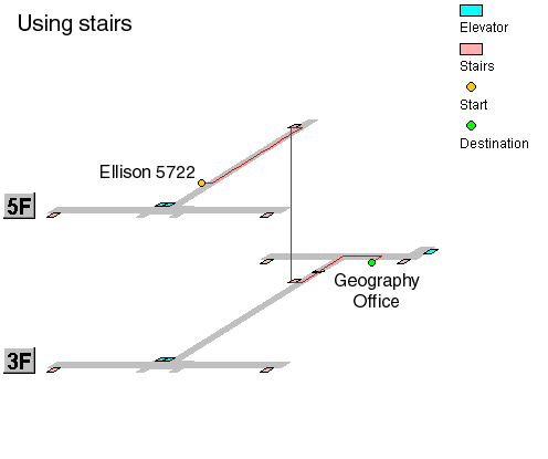
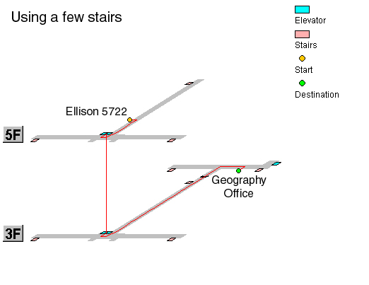
Three diagrams are shown here that illustrate the various accessible routes
in Ellison Hall on the University of
California Santa Barbara campus. As an example, a trip from
my office, Ellison 5722 (5th floor) to the Geography office room 3611
(3rd floor) is depicted given different ambulatory capabilities.
This diagram shows the shortest path for those who can use stairs.
This diagram shows how a person could go if they could use only a few stairs.
This diagram shows how a person using a wheelchair, or a wheeled cart, would have to travel. This clearly demonstrates the extra distance and time that it takes when not completely ambulatory.
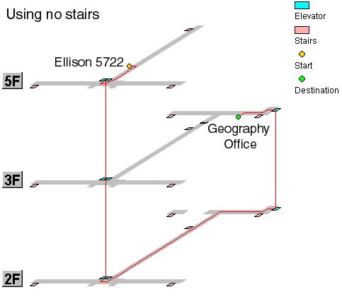
These diagrams show how the stairs that link the two wings of this building dictate three entirely different routes for the same journey. Viewing and comparing these 3 sample shortest paths gives a concise display of the extra distance required to make the same trip for people with varying degrees of mobility.
Another aspect of my research has been to define and quantify the "penalty" in distance or time incurred by people with limited mobility and to formulate an optimal barrier removal program to identify the most cost-efficient mitigation plan. Although people with all three mobility types can reach the destination (absolute access) there is a large distance and/or time penalty (relative access) for those with mobility limitations. For more information on relative access, refer to:
Church, R. L., Marston, J. R., (2003) Measuring Accessibility for People with a Disability , Geographical Analysis.
"Ellison Hall Guidance System" explains the building design problem and the research. A section called "Ellison Hall' explains how the two wings are connected with stairs on some but not all floors. This fact is not visible until a person has traveled to that section of the building, forcing a wheelchair user to turn around and backtrack to the elevator at the other end of the long hallway. The prototype was designed to show relevant facilities such as wheelchair accessible bathrooms, phones, drinking fountains and copy machines.
This link takes you to the directory and mapping site . Here you can search the directory for office locations. The mapping site lets you input your location (using the button "Floor Map / Input Your Position"). Choose a floor and then click the area you are at with the mouse to leave a yellow dot. You then enter the destination you are seeking.
For your first attempt, why not try my office, room 5722, or any office
on the fifth floor as an origin. Just bring up the fifth floor map
and click on the side of a hallway. For a destination input the
Geography office at 3611. Then click "Show Route." Users
can input if they can use no stairs, a few stairs, or want to use stairs.
The "shortest path" in this model is calculated with both a typical linear
network and a "grid" model, which is used to show the many path options
in an open space, such as the courtyard. You can try a route
that takes you through the outdoor open space to the right of the building.
This type of "hybrid network" model is explained in "A study on a system for guiding of the optimal
route with a hybrid network and grid data structure.
We feel that this type of system would be a great benefit for people who have physical limitations to allow them to either pre-plan a trip or find the shortest path on-site. People would not have to explore a building only to find a dead-end caused by a barrier to access. They also would not have to rely on other people for information. A typical ambulatory person does not really remember or understand all the barriers that exist in an area, and even the most helpful person might give incorrect information,
With this building access system, a person would not make wrong route decisions and, thus, would not encounter barriers, avoiding time delays and frustration. Without spending any additional money on barrier removal, the building or environment would “appear” more accessible to users.
This is a bare bones prototype but we would greatly appreciate your input both on the site and your ideas about how or where this type of display is needed.
Jim Marston Ph.D.
Post Doctoral Researcher
Department of Geography
University of California at Santa Barbara 93106-4060
Office Phone & Voice Mail: 805-893-7274
Email: marstonj@geog.ucsb.edu
Web site: http://www.geog.ucsb.edu/~marstonj
Back to Home Page