4.6. Spatial Knowledge Acquisition and Cognitive Maps
In this section, two experimental tasks that attempted to measure the amount of
spatial knowledge that had been acquired while performing the field test are examined.
Much has been written about spatial knowledge acquisition and the creation and
use of mental or cognitive maps regarding people with severe visual limitations.
For a review, see such authors as Dodds, Howarth, & Carter (1982),
Foulke (1983), Golledge (2001), Golledge, Blades, Kitchin, & Jacobson (1999),
Golledge, Kitchin, Blades, & Jacobson (2001), Golledge, Klatzky, & Loomis
(1996), Jacobson (1993), Kitchin (1994), Kitchin & Jacobson (1997), Lockman,
Rieser, & Pick (1981), Long, Rieser, & Hill (1990), Passini (1986), Rieser,
Guth, & Hill (1986), Strelow (1985), and Thinus-Blanc & Gaunet (1997)
.
Despite these reviews and many experiments, there is still little agreement on
how blind people perceive, learn, understand, and internalize geographic spatial
information. However, these research reports do uncover information about
knowledge structure and content and allows for measurement of some kind of “accuracy”
compared to the real environment. Results from the following two experiments
demonstrate the lack of agreement about the skills of people with various degrees
of visual experience. An elegantly crafted experiment showed the effect
of specific visual knowledge (blindfolded sighted), previous general visual experience
(adventitious) and no visual experience (congenital). Subject made comparative
distance judgments between groups of three named locations (choosing the two that
were closest and the two that were furthest apart). The data showed that,
when making distance judgments through walls (as the crow flies), those with no
previous vision experience had the most error, those with specific visual knowledge
of the layout had the fewest errors, and those with previous visual experience,
before losing their sight, fell between those other two groups (Rieser, Lockman,
& Pick, 1980) . Another group of researchers also tested blindfolded
sighted, adventitious and congenitally blind people. Those subjects performed
various physical tasks, such as retracing a multi-segment route in reverse, returning
to the origin after being led around linear segments, and pointing to targets
after locomotion (Loomis et al., 1993) . In contrast, they found little
indication that prior visual experience influences spatial competency.
These differing results can be explained, at least partially, through a closer
examination of the subjects and methods. Rieser et al. tested four
subjects in each group, they were all very familiar with the layout, the blind
subjects were in the process of receiving blind skills training, and the test
was a non-physical recollection of previous knowledge. In the Loomis et
al. experiment, 12 subjects were in each category, they were more independent
as travelers, they had no previous knowledge of the environment, and the layout
was physically experienced during the test. This brief summary of two well
conducted experiments show some of the reason for differences in theories relating
to the skills of people with blindness. These different theories are discussed
later (see Section 7.2.1 , Relevance of this Work
to Spatial Organization Theories of the Blind ).
The intent of the present research is not to add to the wealth of literature about
how spatial information is processed and stored into the cognitive map
of the blind user. Rather, the focus is on examining what can be
learned about the source of restrictions that affect travel and accessibility
for the blind. At its core, spatial knowledge acquisition and cognitive
map accuracy is a primary concern because these have some utility to the user;
the more accurate an individual’s spatial knowledge and mental map, the
easier it would be for a person to navigate an environment and gain access from
one location to another. In this section, how the utility of the subject’s
knowledge is shown through active field tasks in navigating a new environment
is examined.
In the field tests, the blind subjects using RIAS were significantly faster and
more efficient in navigating and finding their destination goal than without the
system. To navigate in a new environment, people must actively orient themselves
to an object or location destination and proceed toward it. But, just as
a sighted person might be able to complete many path segments and still not acquire
a good spatial representation of the area, the navigation accuracy and efficiency,
exhibited by RIAS users, does not necessarily mean that spatial knowledge has
been acquired, processed, and stored.
Sholl (1996) argues that there are two processes used for successful acquisition
and understanding of spatial layouts. People must understand not only the
dynamic person-to-object relationships that occur when navigating a route, but
also the stable object-to-object relationships that are anchored in the environment.
Object-to-object relationships can be quite difficult for the blind because
there are no visual cues or distal vistas providing knowledge of the spatial arrangement
between objects. In addition, optic flow cannot be accessed to monitor
the changing relationships of objects while in motion. This is why some
blind people, though well trained to follow a path, might not easily understand
the environment’s spatial arrangement - the relationship between all objects
- and might be ignorant of entire sections of space. For some blind people,
any deviation off a known route is “terra incognitae,” and sticking
to a known route is the safest, most secure, and, therefore, “optimum”
option. This means that one might have learned and be able to walk a path
from A to B and then to C but have little idea how to go from C to A without retracing
the route, back through B. People with limited or no vision might not have
a good idea of the object-to-object relationship between C and A, and this task
of making “shortcuts” is made even harder because a blind person might
have no idea of what type of environment or terrain lies between C and A.
Therefore, potential barriers, obstacles, unsafe surfaces, and general fear and
apprehension about new environments restrict some blind people to known routes
and locations.
Since cognitive maps are an internal process, there is no way, as yet, to access
and analyze them except through measurement of surrogate and externalized methods.
There appears to be no precise and accurate correspondence between internal spatial
knowledge and what can be discovered through the use of these externalized measurements
or spatial products. For more information on externalized spatial
products , see Golledge (2001) and Kitchin & Jacobson (1997) . The
use of various spatial products can lead to different observations about an individual’s
cognitive map. This problem is evident in the wide range of theories regarding
spatial knowledge acquisition for people with vision restrictions. When
different results are found using different spatial products, it makes it difficult
to know which measure is “correct.” This produces weak convergent
validity, but, when several spatial products reveal similar results, stronger
convergent validity is evident.
To increase this methodological validity, subjects’ cognitive maps
and spatial knowledge (using two different kinds of spatial products
) were examined. A wayfinding and navigation product was used when subjects
were given the opportunity to make several shortcuts in the field test.
The other method used was to examine cognitive maps by asking questions about
object-to-object spatial relationships, with a verbal description product, using
a simple sentence framing technique. The verbal description experiment
is discussed later in this section.
Every attempt to uncover the internalized map knowledge by an external product
has correlation problems. Using navigation tasks is no exception, and they
also add confounding factors. Subjects might use environmental cues, in
addition to their spatial knowledge, to guide their action. On the other
hand, well-controlled laboratory experiments might have less noise, but they can
raise questions of external validity. For example, is the relationship
between objects on a tabletop experiment actually relevant to the person or theory
being studied? Can those results be extrapolated to real-world or geographic
spaces? When considering the important tasks of understanding how the blind
perceive, learn, and, especially, use real-world space, much can be said for tests
that reveal spatial knowledge that exhibits a high degree of usefulness or utility
to the people being studied.
4.6.1. Spatial Knowledge Revealed by Navigation and
Wayfinding Tasks
Chapter 3 discussed two of the field transfer tasks where subjects were allowed
to take any route they chose to locate the next task destination. Figure
3.5 shows the routes taken for transfer task 3 and the location of the RIAS transmitters.
There was occasional construction activity , and therefore subjects were
guided by the researcher out the front door of the terminal and turned left toward
Townsend Street. They turned left again and walked down Townsend to a cabstand
on the street. No information was given about street names or turn direction;
subjects just walked along with, and were guided by, the researcher. Subjects
were then told to find the water fountain in the terminal. No additional
path information was given. The terminal had side doors facing Townsend
Street that led into the station, and these doors were labeled with RIAS transmitters.
No mention had been made of these doors.
To eliminate variance and noise in the data, only those subjects who had no residual
vision are reported on. None of those could see shapes, or objects up close.
There were 20 such subjects in the sample of 30; 11 subjects used their
regular method for their first trial at the terminal, and nine used RIAS for their
first trial.
Air currents and crowd noise might have been available as cues for the blind to
enable them to notice or locate the doors to the street. For the 11 blind
subjects that used their regular methods first, only three (27%) made the shortcut
through the side doors. The rest retraced the longer path they had previously
taken to the cabstand. In contrast, all nine (100%) of the blind subjects
using RIAS on their first trial used the shortcut. Although they had not
been looking for the door, they appear to have learned about it while scanning
around during the previous or current tasks. No formal data was collected,
but the researcher noticed that some subjects heard the side door message while
they were looking for Track #2 (in the previous sub-task), after leaving the track
door on the guided walk, or from the outside while going to the cabstand.
It was also possible to hear the message while starting to retrace the original
path if they were scanning in that direction. Table 4.12 shows the data
for both possible shortcut trials (subjects using NRIAS 2nd
did not perform these tasks). It also shows the results for the within
subject condition where subjects tried RIAS on their second trial.
Results for the subjects who reported they could see shapes and objects up close
are also shown, along with the total for all 30 subjects.
The second route where a shortcut was possible occurred after subjects visited
Track Door #11 at the far end of the terminal. See Figure 3.7 for the diagram
of that route. From that door, they were told to go to the street corner
that had first been visited, but to prepare to cross the other street.
Again, no street names or directions were given. There was a series of
doors across from the track doors that led to a plaza opening up to the street.
This is the kind of situation where, even if a blind person knew there
were doors available, they would not know what was outside the doors, or whether
they could get to the corner without barriers or obstacles in the way.
Only two (18%) of the eleven blind subjects, in the first condition, used the
shortcut through the doors leading to the outside plaza; the others all walked
back down the hall in the opposite direction and went out the main exit that they
had learned in the first task. For the nine blind subjects that used RIAS
first, eight (89%) used the door opposite the track door to directly access the
corner. The RIAS transmitter above the door had the message, “Exit
to 4 th and King plaza.” They must have found this message
while scanning around the environment (either while walking to Track #11 or when
starting the trip to the corner). The message, giving the direction and identity
of the doors, appeared to provide them with enough information to attempt navigation
in a totally new area of the environment (the plaza area).
Table 4. 12
Ability to Make Shortcuts
| |
Cab-stand to
Water Fountain
|
Track Door #11 to
Corner of King and 4th
|
| |
Regular
Method
1st
|
Using
RIAS
2nd
|
Using
RIAS
1st
|
Regular
Method
1st
|
Using
RIAS
2nd
|
Using
RIAS
1st
|
|
No
Vision
|
N = 11
|
N = 11
|
N = 9
|
N = 11
|
N = 11
|
N = 9
|
|
27%
|
91%
|
100%
|
18%
|
64%
|
89%
|
|
Some
Shape
|
N = 2
|
N = 2
|
N = 4
|
N = 2
|
N = 2
|
N = 4
|
|
100%
|
100%
|
100%
|
0%
|
50%
|
100%
|
|
Some Objects
|
N = 2
|
N = 2
|
N = 2
|
N = 2
|
N = 2
|
N = 2
|
|
50%
|
100%
|
100%
|
50%
|
100%
|
100%
|
| |
|
|
|
|
|
|
|
All
Subjects
|
N = 15
|
N = 15
|
N = 15
|
N = 15
|
N = 15
|
N = 15
|
|
40%
|
93%
|
100%
|
20%
|
67%
|
93%
|
The propensity to make shortcuts and the spatial knowledge awareness exhibited
here is a true measure of the utility of their cognitive map. Being able
to make shortcuts shows an understanding of the object-to-object spatial arrangement
and the ability to make efficient route choices, which is the goal or utility
of a good mental representation of an environment. The literature (see
above citations) and statements from blind people state that making shortcuts
is difficult, and that some people retrace their steps rather then try to figure
out if it is possible to take a new route through the environment. As in
the case of a vision-impaired person’s impedance to making transit transfers
(see Section 4.5.1 , Impedance Considerations
while Making a Transfer Decision ), they would rather stay with a known environment
rather then risk obstacles and barriers in a new environment, thus avoiding apprehension
and stress. This inability to access the “best” path is a major
restriction to access in new environments and limits independent travel and learning
spatial arrangements efficiently. Instead of being taught a new path by
a friend, stranger, or O&M instructor, blind people using RIAS appear to learn
an environment on their own and access the environment in the way that it was
designed. An additional benefit of using a system like RIAS is that a person
can learn about locations they were not even looking for. The existence
of the doors that were used for the shortcuts appear to have been learned while
performing previous, unrelated tasks. Subjects did not actively search
for a shortcut when presented with the next destination; rather, they had already
learned and stored that information while doing other tasks. User comments
reported during the experiment also verify how important this ability to discover
new knowledge is to the blind. They are able to learn new environments
and locations without having to stick to a known path, follow other people, or
ask for help. Subjects often mentioned “independence” in their
comments, and the ability to learn new environments without help and the ability
to make shortcuts are major sources of this feeling.
For the two shortcut tests, blind people using their regular method on their first
attempt had 22 chances to make a shortcut, and only five times (23%) were subjects
able to take full advantage of the potential accessibility in the environment
and use the shortest path. When using RIAS, first time subjects had 18
chances to use a shorter path, and all but one (95%) did so. As an objective
measure of accuracy in navigation, the ability to reduce distance by making correct
spatial decisions is fundamental. RIAS demonstrated its ability to save
distance and time for subjects in new environments, making it easier to gain access
to more activities.
Another way to measure cognitive map knowledge is to examine spatial products
revealed by verbal or written descriptions. A type of sentence framing
technique was used where subjects were asked to give the answers to a series of
20 questions that dealt with both spatial arrangements and knowledge of the environment.
Questions that dealt directly with spatial relationships between concession
stands and the ticket window and with relationships between amenities in the waiting
room area were used. Other questions dealt with the spatial arrangement
of the track doors, information about the traffic lane configuration of the streets
they crossed, names of the streets, and other more general spatial relationships
in the terminal environment. To reduce variance and increase validity,
only the subjects who had no useful vision are reported on.
The spatial questions were asked after five transfer tasks were completed, in
the NRIAS 1st , NRIAS 2 nd , and RIAS
1st conditions. Subjects were walked outside the station and
rested on a bench facing away from the station to eliminate any cues about the
questions that followed. Subjects had not been told that any spatial questions
would be asked and so had no way to cognitively prepare for a spatial test.
The questions were given in such an order that no previous question could give
the answer to any further question (see APPENDIX 4 : Subject
Questionnaire for San Francisco RIAS Experiment ). Of the 20 questions asked
of the 11 subjects with no useful vision using their regular method on the first
trial, 44% were answered correctly. When these same subjects used RIAS
on their second trail, the mean number correct rose to 84%. In comparison,
the nine subjects who used RIAS for their first attempt in the field test got
88% correct. The use of RIAS was highly significant; the difference between
the blind group using their regular method and using RIAS on the second
try was (p<.0001) and, when compared to the RIAS first condition, was
(p<.0002). Those using RIAS first actually had better results
than the group who used it second, but the order of the condition had no significance
(p<.56).
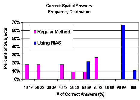
The frequency distribution of each person’s correct scores in their first
trial, between the two groups, was highly skewed in favor of those using RIAS.
The worst scores per subject, out of 20 questions, for those using their
regular methods, were two twos, a four, and a five. The best scores for
that group were a 13, two 14’s and a 15. In contrast, the worse scoring
two subjects using RIAS in their first attempt got 12 correct. Six subjects
missed only one question (19 correct), and one person got all 20 questions right.
What made this even more remarkable was that the control, the first time sighted
user (FTSU; see Section 1.6.6 , Sighted Subjects
for Baseline )got just 16 (80%) correct. RIAS gave so much information
that seven of the nine blind subjects using RIAS first scored higher on
these questions than the first time sighted user. Figure 4.10 shows the
frequency distribution of each subject’s correct answers on their first
trial, a measure of their spatial awareness.
Figure 4. 10 Frequency Distribution of Spatial Awareness
The distribution of how well each question was answered was highly skewed toward
the RIAS condition. The three “easiest” questions were answered
correctly in the regular method condition by 73, 73, and 82 percent of the subjects.
In contrast, the three hardest questions for RIAS users, after their first
field trial, were answered correctly by 67% of the subjects. Eight of the
questions were answered correctly by 100% of the subjects, and another five questions
were missed by just one subject when using RIAS. In the within-subject
condition, all regular users scored better after using RIAS. One person
answered an additional 13 questions correctly, another 10; three got nine, and
two more got eight more correct on their second trail with RIAS. For each
of the 20 questions, those who used RIAS first scored higher than those
who used their regular method first . Table 4.13 shows the questions numbered
and ranked from hardest to easiest in the blind regular condition.
A variety of different questions was asked, and the next section will discuss
these various groups of spatial and information questions. It is difficult
to use externalized spatial products to accurately measure the internal cognitive
map. The main interest here is how that map has real utility for blind
travelers, which information is the hardest to learn without vision, and how these
gaps in the cognitive map can affect independent travel and accessibility.
Using a mixture of question types removes bias caused by the researcher’s
choice of the “correct” way to measure the internalized map and lets
the subjects more clearly speak to the contents of their cognitive map and reveal
which tasks are difficult to master.
Table 4. 13 Spatial Question Analysis
|
Spatial Questions
|
Trial #1
Regular
Method
|
Trial #1
Using
RIAS
|
Type
|
Q #
|
| |
Percent Correct
|
|
|
|
Which track # did we first start at?
|
9
|
78
|
BI
|
1
|
|
Where do the doors across from tracks 9-12 lead?
|
18
|
78
|
BI
|
2
|
|
What street is the taxi stand on?
|
27
|
67
|
SN
|
3
|
|
What street did you cross to get to the Muni rail platform?
|
27
|
100
|
SN
|
4
|
|
What street is in front of the train station?
|
27
|
100
|
SN
|
5
|
|
How many train tracks serve the Caltrain station?
|
27
|
100
|
BI
|
6
|
|
Which tracks are closest to the waiting room?
|
27
|
67
|
TS
|
7
|
|
How many lanes and what direction (one way / two way) is this street
[to the Muni rail platform]?
|
27
|
89
|
SI
|
8
|
|
Which tracks are closest to the main entrance?
|
36
|
67
|
TS
|
9
|
|
How many lanes and what direction (one way / two way) is this street
[in front of the train station]?
|
45
|
78
|
SI
|
10
|
|
Which track door # is closest to track door 7?
|
45
|
100
|
TA
|
11
|
|
Which track door # is closest to track door 6?
|
55
|
100
|
TA
|
12
|
|
What concession counter is closest to the train area?
|
55
|
89
|
CS
|
13
|
|
Which concession counter is closest to or across from the ticket window?
|
55
|
100
|
CS
|
14
|
|
What amenity is closest to the phone?
|
55
|
100
|
AS
|
15
|
|
What amenity is furthest from the phone?
|
55
|
89
|
AS
|
16
|
|
The highest track # is closest to which of the other transit modes we
visited
|
64
|
78
|
GS
|
17
|
|
Which amenity is closest to the water fountain?
|
73
|
89
|
AS
|
18
|
|
Which concession counter is closest to the front street?
|
73
|
89
|
CS
|
19
|
|
What concession counter is closest to the Candy counter?
|
82
|
100
|
CS
|
20
|
|
Mean correct spatial questions
|
44
|
88
|
|
|
The question types and answers in the general order they appear on the table,
sorted from hardest to easiest to learn, are discussed. The order was determined
by the answers of the people using their regular methods of navigation.
4.6.2.3.1. Building Information (BI) Questions #1, 2 and 6
Only one blind subject answered the hardest question (#1) using regular methods
of orientation. Even our FTSU (control) did not know the answer.
Subjects were walked to the beginning location of the test with their eyes closed
and started with their back to the door. There was little utility in knowing
where they started from and few cues available to gain this knowledge.
With RIAS, subjects got this question right 78% of the time. The next hardest
question (#2) asked about the doors across from tracks 9-12 and where they led.
Only two (18%) subjects knew the answer without RIAS. Since most
of the regular method subjects did not even use these doors (for the shortcut)
they had little knowledge that the doors even existed. With RIAS, 78% knew
the correct answer. The other question put in this general building information
group was #6, asking for the total number of tracks at the station. The
highest track number actually visited was #11 and, without knowledge of the track
layout and extent of the hallway, there were few ways to know the correct answer.
For the regular orientation group, three people (27%) knew there were actually
12 track doors. All subjects using RIAS got that question correct.
These three questions asked about information that was not directly needed to
complete the field test, and the results show that this information was not learned
by most of the regular method subjects. Those using RIAS picked up this
information quite well, even though it was not critical to the task and they were
not required to navigate to those locations. This ability to pick up information
about locations while doing other tasks is often impossible without sight, unless
an active and physical search is undertaken. To be able to learn about
the environment while simply walking through it is what vision allows, and this
ability to easily gather spatial information helps make sighted navigation so
much more efficient.
4.6.2.3.2. Street Names (SN) Questions #3,4, and 5
The names of the streets were never mentioned during the experiment, although
some subjects certainly learned them before making the trip to the Caltrain station.
Street names are also not necessary to make successful locomotion but can add
enormously to general spatial understanding and the ability to make crucial spatial
decisions. Questions 3, 4, and 5 all dealt with the names of the three
streets, and, for these questions, only three people (27%) got them right without
the orientation and identity help provided by RIAS. The control (FTSU)
also did not know the names of the three streets. For the street they did
not cross (Townsend), 67% of the subjects got that question correct after using
RIAS. They likely learned that name while scanning toward the side (shortcut)
doors. Subjects crossed 4th and also King Street, and, with
RIAS, they heard the name of the street being crossed while they waited for the
“WALK” message. All subjects using RIAS knew the correct answers
for those two questions. There is little doubt that, although not necessary
for successful locomotion, knowing the names of streets in the environment helps
spatial decision-making and spatial orientation and adds to general knowledge
and peace of mind.
4.6.2.3.3. Tracks, Spatial (TS) Questions #7 and 9
Two questions, 7 and 9, asked about the relationship between track doors and other
locations in the terminal building. Of those using their regular orientation
skills of orientation, only three (27%) knew which tracks were across from the
waiting room, and four (36%) knew which tracks were closest to the main entrance
hallway. When using RIAS, subjects got both of those questions right 67%
of the time. Again, this knowledge was relevant, but not critical, for
the navigation task, but the higher scores show that the use of auditory cues
gave better spatial knowledge of the environment. It is quite difficult
for blind people to get enough distal cues to understand the relationships between
locations in a large open space. With no visual cues to spatial arrangements,
blind travelers must often go to a wall and search along it until finding a location.
Later, they might be at the opposite wall to find other locations.
If the open space between these two locations is an area that is too large to
comprehend without vision, they might have little or no knowledge of the spatial
relationship between the two locations. The two locations might even be
directly across from each other, but this knowledge can be hard or impossible
to acquire, at least without much physical activity.
4.6.2.3.4. Street and Lane Information (SI) Questions #8 and 10
Crossing streets safely and successfully requires gaining information from various
modalities. One listens to traffic sounds and tries to determine the shape
of the intersection, traffic flow and speed, lane direction, and turn lane cycle
information. Two questions (8 and 10) asked about the two streets that
were crossed in the experiment. They asked about how many lanes the subjects
had crossed and whether they were one-way or two-way streets. The regular
users got 27% and 45% of these two questions correct, even though they crossed
each of the streets twice. RIAS users got 87% and 78% correct on the same
two streets. This information is not mandatory for successful locomotion,
but the knowledge certainly adds to the safety and success of a street crossing.
For instance, not knowing that a street is one or two ways or has an extra
turn lane could lead to serious accidents or death. It also helps to know
lane and direction information in advance so that one can know what to listen
for while waiting to cross the street
4.6.2.3.5. Track Arrangement (TA) Questions #11 and 12
Figure 1.1 shows the twelve tracks serving the Caltrain terminal. Tracks
1 and 2 are separated by a wide concrete shared boarding platform, and this
pattern is repeated up to the final shared boarding platform for tracks 11 and
12. There are two sets of double doors that open from the terminal onto
each shared platform. Thus, doors for track 1 and track 2 are directly
next to each other, while track 3 is quite a distance away (where it is next
to the door for track 4). The spatial arrangement of the doors and tracks
is not easily discernable without sight. Two questions were asked to
determine if the subjects had learned the spatial arrangement of the track layout.
Questions 11 and 12 asked subjects to state which track door # was closest
to another. The people using their regular skills got 45% and 55% of these
two questions correct. Even after visiting various track doors three
times, about half still did not show knowledge that the doors were arranged
in groups of two (with the odd number door on the right and the even one on
the left). This is critical information needed to make efficient navigation
and full use and access of a train terminal. With the use of the information
provided by the auditory and directional cues, 100% of the subjects knew that
the doors were arranged in groups of two, so that track #8 was closest to #7
and track #5 was closest to #6. There is a high utility associated with
having this type of information. Since there was no Braille or tactile
information on the doors, it could have taken quite a while for a blind person
to understand this arrangement and extrapolatethis arrangement to all platform
doors in the current environment.
4.6.2.3.6 Concessions, Spatial (CS) Questions #13,14,19, and 20
During the field test, subjects visited all three concession stands and the
ticket window (twice) in the main hallway. The person-to-object information
they acquired while walking to these locations appears to have been formed into
a better object-to-object understanding than other types of locations.
For questions 13 and 14, subjects using normal orientation skills got 55% of
those questions correct. In contrast, with RIAS, one of the questions
was answered correctly by 100% of the subjects, and the other question had one
incorrect answer (89%.) Regular users answered 73% and 82% of the other
two questions about the spatial arrangement of the concession stands correctly,
and, with RIAS, they scored 89 and 100% respectively. Clearly, the active
search and navigation allowed subjects to understand these types of spatial
relationships better than some of the other types of locations. The area
between the four locations was quite small and fairly easy to understand.
4.6.2.3.6. Amenity, Spatial (AS) Questions #15,16, and 18
Each of the subjects visited three amenities in the waiting room during the field
test. They found the “correct” bathroom, the phones, and the
water fountain. This was a very small area; the locations were just a few
feet away from each other, although they were on three different (90 degree
separation) walls. Although these locations were almost touching each other,
only 55% of the normal orientation subjects were able to identify what was closest
to the phone and also what was furthest from the phone. RIAS users scored
100 and 89% on those 2 questions respectively. Regular navigation subjects
scored 73% when asked what was closest to the water fountain, and RIAS users scored
89% on that question.
4.6.2.3.7. General Spatial (GS) Question #17
There was one question that did not fit any of the groups. It dealt with
not just the terminal but with the entire area that had been navigated, including
the cab stand, the bus shelter across 4 th Street, and the Muni rail
station across King Street. The question asked subjects to identify which
transit mode was closest to the highest track # at the terminal. The Muni
rail station was directly across one sidewalk and two lanes of traffic from the
highest track number. The cab stand and bus shelter were much further away.
RIAS users got this general spatial question correct 78% of the time, and,
without the system, subjects got this correct 64% of the time. Results
on this question were probably confounded by some subjects not considering closest
to mean “as the crow flies” distance.”
4.6.3. Summary of Spatial Knowledge Acquisition and
Cognitive Maps
A researcher using some type of externalized means of measurement must extract
the information stored in a person’s cognitive map. Different spatial
products are likely to reveal differing amounts and types of information.
Two methods were used to gain more convergent validity and concentrated on testing
if these observed internalized spatial representations had utility for the user.
Except for one trial, all subjects using
RIAS (95.5 correct) were able to identify unvisited doors and make a successful
shortcut to the next destination.
With their normal methods, all but 3 attempts
(23% correct) led to making the longer (retrace) path, not having the knowledge
to make a shortcut.
RIAS allowed users to find information
they were not actively searching for and use it later to affect more efficient
travel.
All 20 spatial and knowledge questions
were answered correctly by more people when using RIAS. There were many
incorrect answers for the regular users; and most RIAS users scored exceedingly
well. In fact, 78% of the RIAS users scored better than the fully sighted
first time visitor (control).
Regular navigation skills led to higher
correct scores for spatial locations that they had visited quite often.
The best results were those associated with the relationships between concession
stands and the ticket window, the amenities in the waiting room, and the general
layout of the entire site. All these types of places were visited multiple
times, and this helped increase their accuracy.
Subjects that used their regular orientation
skills had little success incorporating knowledge about places that they did not
actively visit. They had difficulty knowing the names of the streets that
they had used and also the information about the streets’ characteristics.
Subjects without RIAS also had trouble
understanding the arrangement of the track doors, even after 3 visits.
Cognitive mapping research concerned with blind travel provides information on
what restrictions exist and what cues are missing. It allows the testing
of assistive devices against known behavior and spatial awareness. These
two experiments, assessing subjects’ ability to make shortcuts and spatial
knowledge, provide information about how hard it is to learn spatial information
without vision, unless the area is accessed repeatedly. Blind users trying
to navigate unknown spaces can be at a great disadvantage, and that affects their
ability to have ready access to many new environments. Many cannot easily,
efficiently, or independently learn new environments without much effort or training.
This incomplete spatial knowledge affects the ability to gain reasonable
access and could be a reason why many blind people report very limited travel
behavior or never venture out alone. Even with multiple visits, spatial
relationships remain elusive for some. The ability to increase one’s
spatial knowledge with auditory signs, by providing easy access to missing directional
and identity cues, allows for independent and dignified wayfinding. These
auditory cues allow blind users to gain some of the critical spatial information
that a sighted person can access, and they allow for efficient behavior such as
the ability to make shortcuts and learn the layout of an environment.
By comparing cognitive mapping results of an assistive aid such as RIAS to the
regular method baseline, much needed knowledge is gained about what cues are needed
and how to best present these navigation cues to a user. These two tests
provide evidence that, with the availability of additional cues giving direction
and location identity, blind people can form an accurate cognitive knowledge of
an area just as well as a sighted person. They can learn locations without
visiting them and are able to use this knowledge (utility) to take advantage of
the access potential of an environment, something that has previously been denied
to them. This empirical evidence should put to rest the notion that there
are inherent flaws in the ability to acquire spatial knowledge without sight.
Blind people appear to have the processing ability required to understand
geographic space, and it is the lack of accessible cues that can cause inferior
spatial knowledge. It appears that RIAS provided essential spatial information
that was mostly lacking, thus allowing blind travelers to use spatial skills that
are otherwise suppressed.