Lecture Notes for Clarke, K. C. Analytical and Computer Cartography
Lecture 11: Map Transformations
Transformations and Algorithms (Review)
- In mathematics, transformations are expressed as equations.
- Solutions, inversion as so forth are by algebra, calculus etc.
- In computer science, a set of transformations defining a process is called
an algorithm.
- Any process that can be reduced to a set of steps can be automated by an
algorithm.
data structures + transformational algorithms = maps
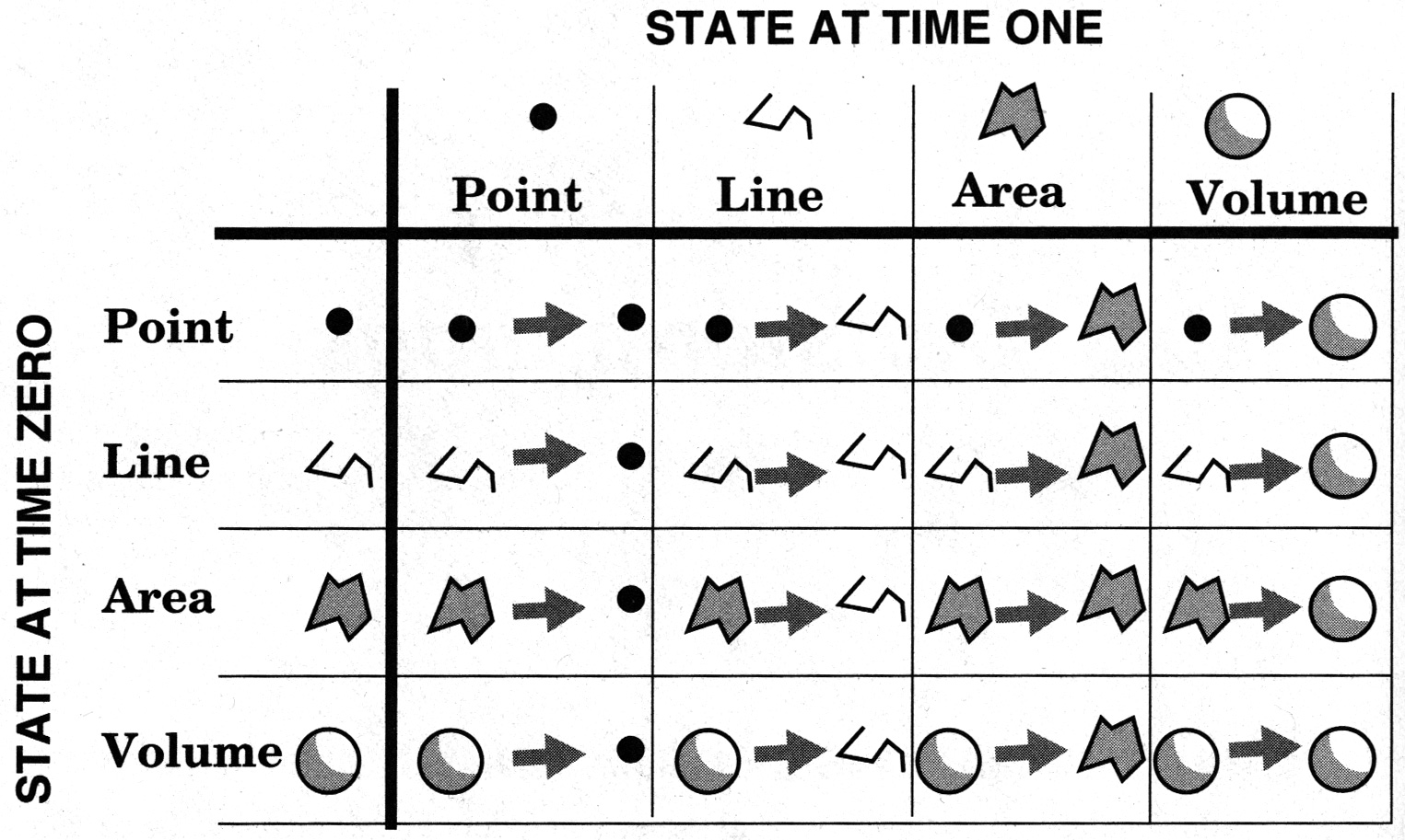
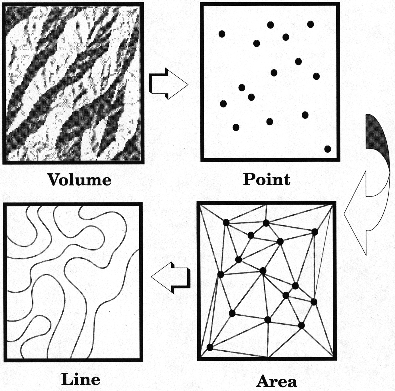
Transformations of Object Dimension
- The four dimensions of dimension, data can be represented at any one in
one state
- Transformations can move data between states
- Full set of state zero to state one transformations is then 16 possible
transformations
- Lab exercises fall into several of these.
- Dimensional transformation are only one type
- When dimension collapses to "none" result is a measurement
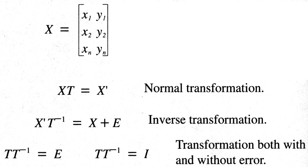
Map Transformation Algebra
- Transformations map closely onto Matrix algebra
- Almost all spatial data can be placed into an (n x m) or (n x p) matrix
- Transformations can then be by convolution (iteration of a matrix over an
array OR
- By selecting a small matrix (2 x 2) or (3 x 3) for multiplication
- Complex transformations can be compounded
- Matrices have inverses, which reverse effect of multiplication to yield
the identity matrix
- Error creep in when inversion does not result in identity matrix
Transformations as Multiple Steps (Dimensional Transforms)
- Also serve to generate measurements, scalars = cartometry
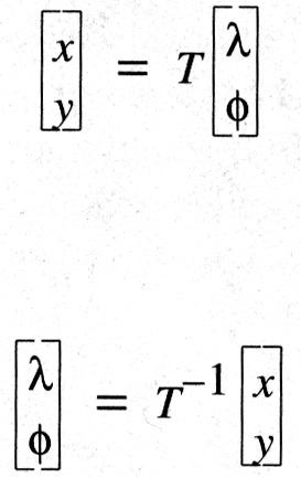
Map Projection Transformations
- Map projections represent many different types of transformation
- Perfectly invertible (one-to-one)
- One-to-many
- Many-to-one
- Undefined (non-invertible)
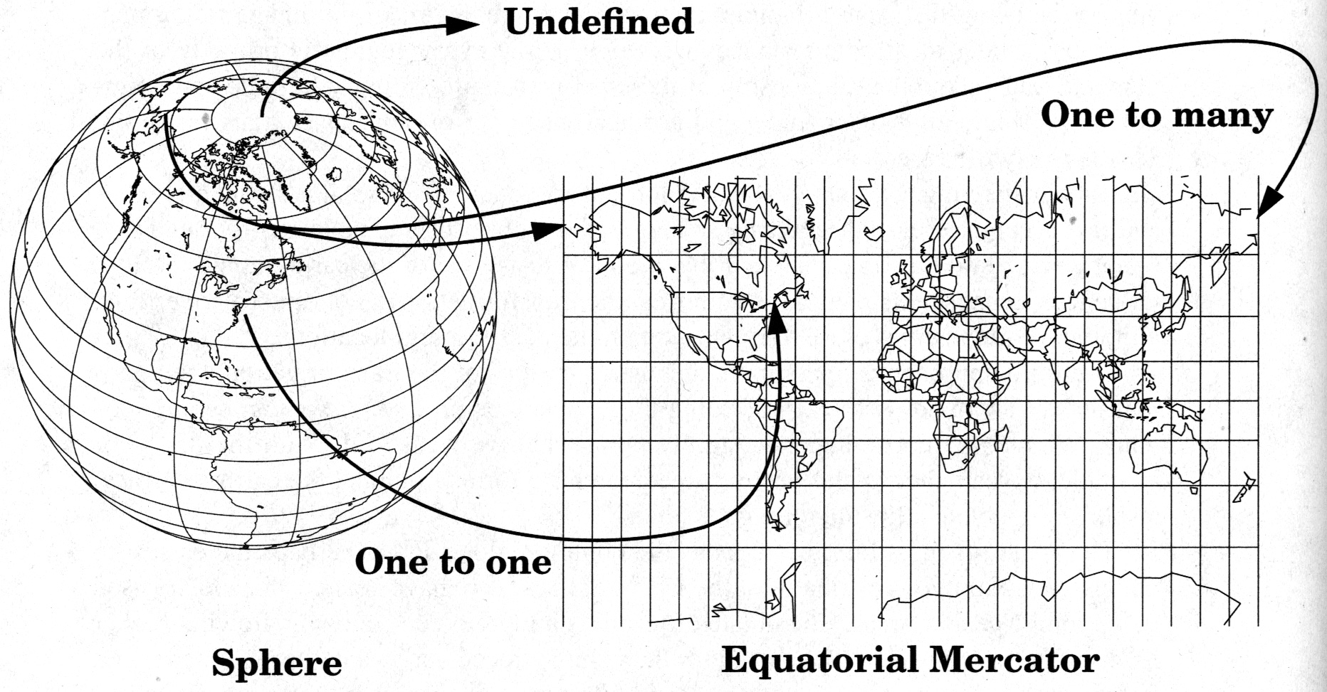
- Imperfectly invertible, e.g. on ellipsoid and geoid, computational error,
rounding etc.
- Some transformations use iterative methods i.e. algorithms, not formulas
PLANAR MAP TRANSFORMATIONS
Transformations Based on Points
Distance Between Two Points
- Simple transformation requiring two points
- Point (line) to scalar (non-invertible).
- Precise and accurate for vector. Less so for raster.
- Accuracy depends on map projection!
- Can be done on sphere, hard on ellipsoid
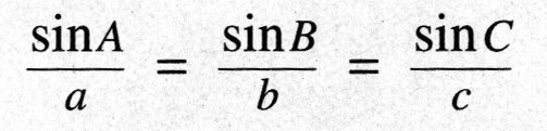
- Law of sines translates to lengths as angles
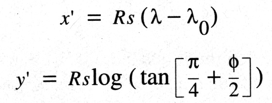
- Mercator Projection
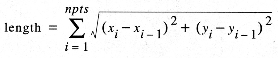
Length of a Line
- Repetitive application of point-to-point distance calculation
- For n points, algorithm/formula uses n-1 segments
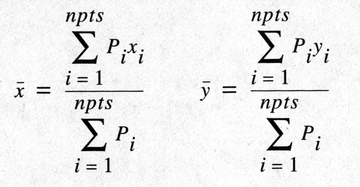
Centroids
- Multiple point or line or area to be transformed to single point
- Point can be "real" or representative
- Mean center simple to compute but may fall outside point cluster or polygon
- Can use point-in-polygon to test for inclusion
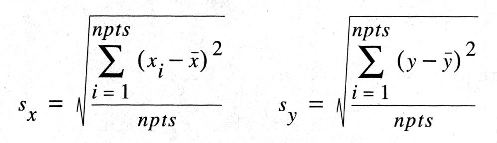
Standard Distance
- Just as centroid is an indication of representative location, standard distance
is mean dispersion
- Equivalent of standard deviation for an attribute, mean variation from mean
- Around centroid, makes a "radius" tracing a circle
Nearest Neighbor Statistic
- NNS is a single dimensionless scalar that measures the pattern of a set of
point (point-> scalar)
- Computes nearest point-to-point separation as a ratio of expected given
the area
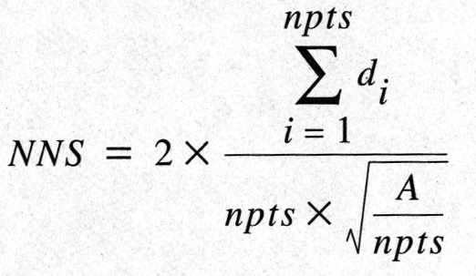
- Highly sensitive to the area chosen
Keith Clarke Last Change 5/8/97 Copyright Prentice Hall, 1995