When using these data or images, please cite:
Bookhagen, B. (in review): High resolution spatiotemporal distribution of rainfall seasonality and extreme events based on a 12-year TRMM time series, in review.
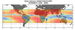
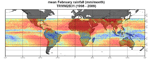
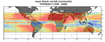
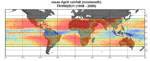
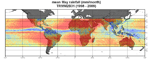
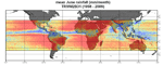
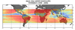
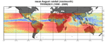
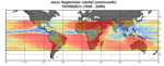
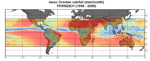
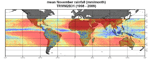
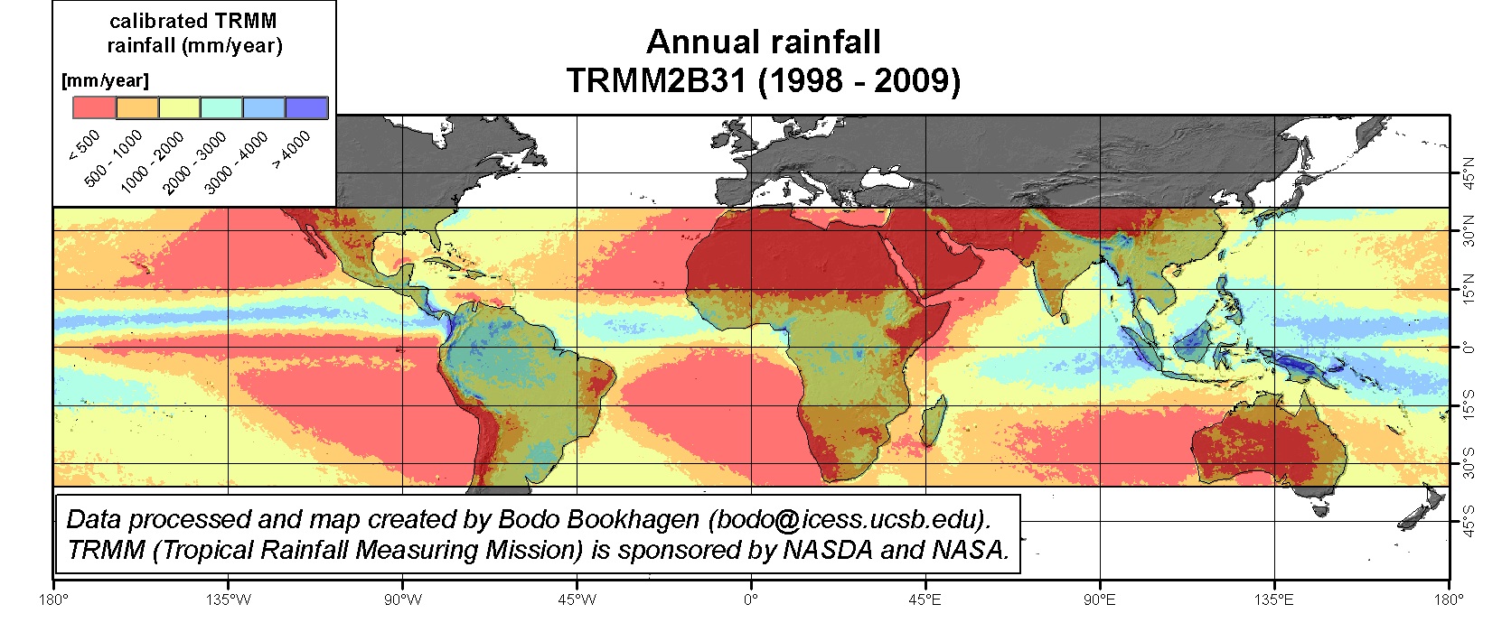
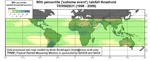
Click on one of the following images to see a detailed view of monthly (mm/month), annual (mm/year), or extreme event (90th percentile) rainfall
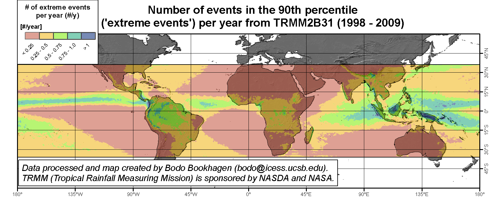
During the past years and months, I have processed the data product 2B31, a combined Precipitation Radar (PR) / TRMM Microwave Imager (TMI) rain-rate product with path-integrated attenuation at 4 km horizontal and 250 m vertical resolutions. Data are available at a nearly global scale for the past 12 years (1998 to 2009). I will continue to process these data and make them publically available.
Please follow the links to one of the following manuscript to obtain more information on data processing, calibration, and application examples :
Bookhagen, B. (in review): High resolution spatiotemporal distribution of rainfall seasonality and extreme events based on a 12-year TRMM time series, in review.
Bookhagen, B. and Burbank, D.W. (in press): Towards a complete Himalayan hydrological budget: The spatiotemporal distribution of snow melt and rainfall and their impact on river discharge, Journal of Geophysical Research-Earth Surface, doi:10.1029/2009jf001426.
Bookhagen, B. (2010): Appearance of extreme monsoonal rainfall events and their impact on erosion in the Himalaya, Geomatics, Natural Hazards, and Risk, 1, 1, pp. 37-50.
Bookhagen, B. and Strecker, M.R. (2010): Modern Andean rainfall variation during ENSO cycles and its impact on the Amazon Basin, in Neogene history of Western Amazonia and its significance for modern diversity, eds. C. Hoorn, H. Vonhof, F. Wesselingh, Blackwell Publishing, Oxford.
Bookhagen, B. and Strecker, M.R. (2008): Orographic barriers, high-resolution TRMM rainfall, hillslopes angles, and relief variations along the eastern Andes, Geophysical Research Letters, 35, L06403, doi:10.1029/2007GL032011. [download Data Repository]
Bookhagen, B. and Burbank, D.W. (2006): Topography, Relief, and TRMM-derived rainfall variations along the Himalaya, Geophys. Res. Lett., 33, L08405, doi:10:1029/2006GL026037. [download Data Repository] [selected as AGU Editor's Choice in May 2006]
Please send any comments and suggestions to Bodo Bookhagen (bodo@icess.ucsb.edu).
<<
Download GeoTIFF files
The GeoTIFF files contain world files (*.tfw) that allow direct importing into ESRI ArcGIS, Globalmapper, GRASS, ENVI, or other GIS and remote-sensing software packages. There is a zip file containing calibrated monthly data (January to December) and the calibrated mean annual data. The units are mm/month for the monthly data and mm/year for the annual data.
<<
Download NetCDF files
The NetCDF files contain all necessary information to display the data in georefenced format. Note: You can open and convert NetCDF in ESRI's ArcGIS 9.2 and higher by dropping the file into the main display window. There is a zip file containing calibrated monthly data (January to December) and the calibrated mean annual data. The units are mm/month for the monthly data and mm/year for the annual data.
<<
Download ASCII Grid files
The ascii files are ESRI grid files that can be imported into several GIS and remote-sensing software packages. The projection of the files are GEOGRAPHIC and the datum is WGS84. There is a zip file containing calibrated monthly data (January to December) and the calibrated mean annual data. The units are mm/month for the monthly data and mm/year for the annual data.
<<
Download Google Earth Overlay
The KMZ file contains all monthly and annual data for displaying purposes. Note: These data are for displaying purposes only. The units are mm/month for the monthly data and mm/year for the annual data.
<<
Please send any comments and suggestions to Bodo Bookhagen (bodo@icess.ucsb.edu).
